1890s Maps of Montana
Explore 27 historic maps of Montana from the 1890s. These maps offer a rare glimpse into what life looked like during the 1890s — showing old roads, neighborhoods, homes, and landmarks that have changed or disappeared over time.
Whether you're researching your family's past, planning a metal detecting trip, or studying how Montana's landscape evolved across the 1890s, these high-resolution maps are a powerful tool for exploring the history of this region.
- Focus on a specific era: All maps on this page are from the 1890s, giving you a focused view of this time period.
- See what’s changed: Compare century-old streets, trails, and buildings to today's modern landscape using overlays and satellite layers.
- Research with precision: Use these maps for genealogy, historical research, land use analysis, or educational projects.
- View, download, or print: Maps are fully viewable online in high resolution, and can be downloaded or printed for your own records.
Start exploring Montana's history through authentic maps from the 1890s. This is your window into the past.
Montana maps
(27)- 1890 Map of Fort Benton
 1890 Fort Benton1890 Print · USGSUpper Missouri river country was transforming in the late nineteenth century as rail lines and ranching settlements expanded across the plains. Genealogists and historians can trace early land routes between Fort Benton, Stanford, and the mining district around Clendenin.
 - 1891 Map of Livingston
 1891 Livingston1891 Print · USGSUpper Yellowstone River country is documented here in the late nineteenth century as the railroad transformed the valley. Genealogists and historians can trace rail-stop towns like Cokedale, the military grounds at Ft. Ellis, and the Old Crow Agency.
 - 1891 Map of Big Timber
 1891 Big Timber1891 Print · USGSMontana ranching country and the Yellowstone valley are captured here in the late nineteenth century. Trace the early Northern Pacific Railroad line through Big Timber and Greycliff, or locate the Harrison Ferry crossing.
 - 1892 Map of Fort Benton
 1892 Fort Benton1892 Print · USGSUpper Missouri River country in the late nineteenth century shows the transition from river commerce to the iron horse. Genealogists and historians can trace early settlements like Stanford and Fort Benton alongside the St Paul Minneapolis and Manitoba Railroad.
 - 1892 Map of Stillwater
 1892 Stillwater1892 Print · USGSThe Yellowstone valley in the late nineteenth century was a corridor of rapid transition as the railroad moved westward alongside the Crow Indian Reservation. Researchers can trace early river crossings and pioneer settlements such as Merrill, Stillwater, and the Ford at Youngs Point.4 unique versions available
 - 1893 Map of Helena
 1893 Helena1893 Print · USGSMontana's gold and silver boom is captured here in the late nineteenth century, showing the rail lines and mining camps radiating from the territorial capital. Genealogists and historians can trace the early layout of Helena or locate vanished sites like Blackfoot City and Gloster.2 unique versions available
 - 1893 Map of Dillon
 1893 Dillon1893 Print · USGSSouthwestern Montana’s mountain ranges and river basins were being reshaped by the mining and rail boom in the late nineteenth century. Genealogists and historians can trace the early layout of Dillon and vanished camps like Hecla, Rochester, and Argenta.5 unique versions available
 - 1893 Map of Livingston
 1893 Livingston1893 Print · USGSThe Montana mountain country and the gateway to the national park are captured here in the late nineteenth century. Trace the industrial rail corridor through Livingston to mining sites like Coke and the historic Old Crow Agency.5 unique versions available
 - 1893 Map of Big Snowy Mountain
 1893 Big Snowy Mountain1893 Print · USGSCentral Montana in the late frontier era reveals a landscape shaped by the massive Big Snowy Mountain and the headwaters of major rivers. Researchers can trace early settlements and transit points like Ubet, Judith Gap, and the remote outpost of Bercail.4 unique versions available
 - 1893 Map of Big Timber
 1893 Big Timber1893 Print · USGSBig Timber and the Yellowstone valley appear here during the expansion of the rail-and-river economy in the late nineteenth century. Researchers can trace the original Northern Pacific Railroad route and locate early river crossings like Harrison Ferry and settlements at Greycliff.4 unique versions available
 - 1893 Map of Huntley
 1893 Huntley1893 Print · USGSThe Yellowstone River valley and the Crow Indian Reservation dominate this late nineteenth-century Montana landscape. Genealogists and researchers can trace the early rail corridor of the Northern Pacific Railroad through Huntley and the station at Clermont.6 unique versions available
 - 1894 Map of Rosebud
 1894 Rosebud1894 Print · USGSThe Big Horn Basin and the Crow Indian Reservation are captured in the late nineteenth century as early cattle outposts began to dot the river valleys. Genealogists and local historians can trace early holdings like Forty Mile Ranch, Hams Ranch, and the Sand Hills Ranch.
 - 1894 Map of St. Xavier
 1894 St. Xavier1894 Print · USGSThe Crow Indian Reservation in the 1890s is captured here just as the frontier era was closing. Researchers can trace the path of the Old Bozeman Military Road past St. Xavier Mission and the Site of Old Fort C. F. Smith.
 - 1894 Map of Fort Custer
 1894 Fort Custer1894 Print · USGSBig Horn County was still a frontier landscape in the 1890s, defined by the meeting of the Big Horn River and Little Big Horn R. You can trace the early railroad at Pompey Pillar Sta. and the grounds of the Fort Custer Military Reservation.4 unique versions available
 - 1894 Map of Three Forks
 1894 Three Forks1894 Print · USGSSouthwestern Montana thrives along the river forks and rail lines during the mid-1880s. Genealogists and historians can trace early town sites like Pony, Logan, and Salesville while locating river crossings such as Fly's Bridge and Shedds Bridge.
 - 1894 Map of Little Belt Mts.
 1894 Little Belt Mts.1894 Print · USGSCentral Montana in the late nineteenth century is a land of emerging mining camps and river valley outposts. Historians can trace the early footprints of White Sulphur Spring, the copper prospects at Copperopolis, and the mountain terrain of Neihart.2 unique versions available
 - 1895 Map of Three Forks
 1895 Three Forks1895 Print · USGSSouthern Montana was a landscape of emerging rail towns and gold-country gulches during the mid-1890s. Genealogists and historians can trace the early footprints of Bozeman, locate Guns Ranch, and follow the Northern Pacific Railroad through Three Forks.5 unique versions available
 - 1895 Map of Canyon
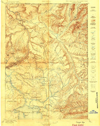
 1895 Canyon1895 Print · USGSYellowstone's early park architecture and geothermal wonders are captured here in the late nineteenth century. Trace early routes past the Baronett Bridge, the Hotel on the lake, and the storied settlement at Yanceys.
 - 1895 Map of Dayton
 1895 Dayton1895 Print · USGSSheridan County and the Bighorn foothills are captured here in the late nineteenth century as ranching and transit began to define the region. Genealogists and researchers can trace the early road networks connecting Dayton, Ohlman, and the ranching hub at Beckton.
 - 1896 Map of Canyon
 1896 Canyon1896 Print · USGSYellowstone National Park is documented in the mid-1890s, capturing the early landmarks and hydrothermal features of the canyon country. Trace the early outposts at Yanceys or the Hotel and locate thermal sites like Calcite Springs and the Fossil Forest.2 unique versions available
 - 1897 Map of Fort Benton
 1897 Fort Benton1897 Print · USGSUpper Missouri River territory is charted here during its transition from a river-based economy to a rail-and-ranching frontier. Researchers can trace the early layouts of Fort Benton and Stanford, or locate remote sites like Barker Mtn and Riceville.4 unique versions available
 - 1897 Map of Little Belt Mts.
 1897 Little Belt Mts.1897 Print · USGSMeagher County and the central Montana high country are captured here in the 1890s, when mining camps and early ranching outposts were first being established. Researchers can trace the early layout of White Sulphur Springs and locate now-quiet sites like the Sapphire Mine or Copperopolis.
 - 1898 Map of Granite Mountain District
 1898 Granite Mountain District1898 Print · USGSThe Beartooth Range appears here in the late nineteenth century during a specialized survey for regional coal and electric companies. Researchers can trace early mountain pathways through Goose Lake Pass and locate major summits like Granite Peak and Mt Dewey.
 - 1898 Map of Little Belt Mts.
 1898 Little Belt Mts.1898 Print · USGSCentral Montana in the late nineteenth century is a landscape of mountain mining camps and early ranching outposts. Genealogists and historians can trace the pioneer footprints of White Sulphur Springs, the operations at Sapphire Mine, and the route of Sixteenmile Creek.
 - 1899 Map of Boulder
 1899 Boulder1899 Print · USGSJefferson County was at the peak of its mining and railroad boom when this survey was conducted. Genealogists and historians can trace the foundations of Boulder and Wickes, as well as numerous hard-rock sites like the Hidden Treasure Mine and Amazon Mill.4 unique versions available
Showing maps 1-25 of 27
Top cities of Montana
- Billings historical maps
- Missoula historical maps
- Great Falls historical maps
- Bozeman historical maps
- Butte historical maps
- Helena historical maps
See more
Top counties of Montana
- Yellowstone County historical maps
- Missoula County historical maps
- Gallatin County historical maps
- Flathead County historical maps
- Cascade County historical maps
- Lewis and Clark County historical maps
See more
Frequently asked questions
- What are the different types of historical maps available for Montana?
- What is the oldest map of Montana?
- Where can I purchase historical maps of Montana for my home or office?
- Where can I download high-res historical maps of Montana?
- Are there historical topographic maps available for Montana?
- Is there historical aerial imagery available for Montana?
- Where are historical maps of Montana sourced from?