1920s Maps of Montana
Explore 13 historic maps of Montana from the 1920s. These maps offer a rare glimpse into what life looked like during the 1920s — showing old roads, neighborhoods, homes, and landmarks that have changed or disappeared over time.
Whether you're researching your family's past, planning a metal detecting trip, or studying how Montana's landscape evolved across the 1920s, these high-resolution maps are a powerful tool for exploring the history of this region.
- Focus on a specific era: All maps on this page are from the 1920s, giving you a focused view of this time period.
- See what’s changed: Compare century-old streets, trails, and buildings to today's modern landscape using overlays and satellite layers.
- Research with precision: Use these maps for genealogy, historical research, land use analysis, or educational projects.
- View, download, or print: Maps are fully viewable online in high resolution, and can be downloaded or printed for your own records.
Start exploring Montana's history through authentic maps from the 1920s. This is your window into the past.
Montana maps
- 1920 Map of Flathead Lake
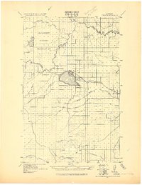
 1920 Flathead Lake1920 Print · USGSWestern Montana at the dawn of the twenties reveals a landscape being transformed by irrigation and rail. Genealogists can trace family roots in early settlements like Polson, Ronan, and Dayton, or locate landmarks such as Wild Horse I. and the Pablo Reservoir.
 - 1920 Map of Choteau
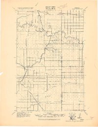
 1920 Choteau1920 Print · USGSNorth-central Montana in the early twentieth century shows a landscape being reshaped by irrigation canals and competing rail lines. Family historians can trace early settlements like Agawam, Bole, and Gilman, or locate regional landmarks like Priest Butte and Pishkun Reservoir.
 - 1920 Map of Dupuyer
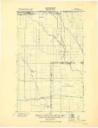
 1920 Dupuyer1920 Print · USGSHigh plains ranching and early irrigation projects define this 1920s survey of the Montana frontier. Genealogists and historians can trace the early rail stops and homestead hubs at Valier, Pendroy, and Manson along the Montana Western R. R. line.
 - 1920 Map of Avery
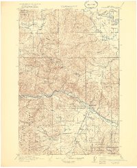
 1920 Avery1920 Print · USGSPhillips and Blaine counties appear here just after the Great War, showing the rural network of the Montana high plains along the Canadian border. Genealogists can locate early community hubs like Caldwell P.O., Turner, and rural schools such as Hubert S.H..
 - 1920 Map of Cowan
 1920 Cowan1920 Print · USGSNorthern Phillips County sits along the Canadian border in the early twentieth century, showing a landscape defined by the Milk River irrigation project. Genealogists can locate isolated rural schoolhouses like Broderson School and Berg School or trace the early post offices at Freewater P.O. and Lovejoy P.O.
 - 1920 Map of Conrad
 1920 Conrad1920 Print · USGSNorthern Montana plains at the height of the homesteading era are captured here during a period of rapid rail-led growth. Researchers can trace early postal locations like Omholt P. O. and the junction of the Great Northern R. R. in towns like Conrad and Brady.
 - 1920 Map of Libby
 1920 Libby1920 Print · USGSNorthwest Montana in the early twentieth century shows a landscape shaped by the Great Northern RR and industrial mining. You can locate family landmarks like Morrow Ranch, the Snowstorm Mines, and early post offices at Troy and Heron.
 - 1920 Map of Gildford
 1920 Gildford1920 Print · USGSNorthern Montana's high plains meet the Canadian border in this era of early rail expansion and homesteading. Genealogists and local historians can trace family-named outposts and rural junctions like Pugsley & Simpson, Wilson's Crossing, and Lilacs.
 - 1920 Map of Jennings
 1920 Jennings1920 Print · USGSNorthwest Montana in the early twenties is captured here as a landscape of timber, rail, and isolated homesteads. Genealogists can trace family-named locations such as Corries Ranch and Deegan Ranch, or locate the site of the Mamicke P.O. near the Fisher River.
 - 1921 Map of Drummond
 1921 Drummond1921 Print · USGSGranite and Missoula counties are seen here in the years following the Great War, as mining camps and valley ranches defined the local economy. Genealogists can trace family homesteads like Williams Ranch or locate rural landmarks including Sunset School and Garnet.3 unique versions available
 - 1921 Map of Elbow Lake
 1921 Elbow Lake1921 Print · USGSThe Montana wilderness near Missoula is captured here during the early 1920s, showcasing the transition of the former reservation lands. Genealogists and hikers can trace early routes like the Gordon Trail and locate historical landmarks such as Gordon Ranch and Holland Lake R.S.
End of results
Showing maps 1-11
Top cities of Montana
- Billings historical maps
- Missoula historical maps
- Great Falls historical maps
- Bozeman historical maps
- Butte historical maps
- Helena historical maps
See more
Top counties of Montana
- Yellowstone County historical maps
- Missoula County historical maps
- Gallatin County historical maps
- Flathead County historical maps
- Cascade County historical maps
- Lewis and Clark County historical maps
See more
Frequently asked questions
- What are the different types of historical maps available for Montana?
- What is the oldest map of Montana?
- Where can I purchase historical maps of Montana for my home or office?
- Where can I download high-res historical maps of Montana?
- Are there historical topographic maps available for Montana?
- Is there historical aerial imagery available for Montana?
- Where are historical maps of Montana sourced from?