1910s Maps of Oregon
Explore 40 historic maps of Oregon from the 1910s. These maps offer a rare glimpse into what life looked like during the 1910s — showing old roads, neighborhoods, homes, and landmarks that have changed or disappeared over time.
Whether you're researching your family's past, planning a metal detecting trip, or studying how Oregon's landscape evolved across the 1910s, these high-resolution maps are a powerful tool for exploring the history of this region.
- Focus on a specific era: All maps on this page are from the 1910s, giving you a focused view of this time period.
- See what’s changed: Compare century-old streets, trails, and buildings to today's modern landscape using overlays and satellite layers.
- Research with precision: Use these maps for genealogy, historical research, land use analysis, or educational projects.
- View, download, or print: Maps are fully viewable online in high resolution, and can be downloaded or printed for your own records.
Start exploring Oregon's history through authentic maps from the 1910s. This is your window into the past.
Oregon maps
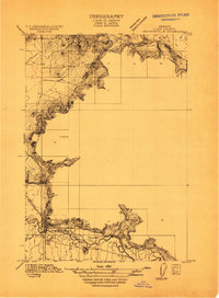
(40)- 1910 Map of Eugene
 1910 Eugene1910 Print · USGSThe upper Willamette Valley comes to life in the years before the Great War, centered on the growing campus of the University of Oregon. Genealogists can trace family footprints across dozens of local school districts like Santa Clara and Deadman, or follow the early tracks of the Oregon Electric RR.2 unique versions available
 - 1911 Map of Brownsville
 1911 Brownsville1911 Print · USGSBrownsville and the surrounding Linn County valley floor appear here during the early twentieth century. Genealogists and local historians can trace the early rail corridor of the Southern Pacific and locate rural landmarks like Rock Hill School and Warren School.
 - 1911 Map of Lebanon
 1911 Lebanon1911 Print · USGSLinn County agriculture and rail travel are in full bloom here in the decade before the First World War. Researchers can trace the early foundations of Lebanon or locate specific country schoolhouses like Gore School and Stoltz Hill School near the base of Peterson Butte.
 - 1911 Map of Monroe
 1911 Monroe1911 Print · USGSThe Willamette Valley foothills meet the river bottomlands in the early twentieth century near the Benton and Lane county border. Genealogists and researchers can trace early settlements at Bellfountain and Alpine or locate rural landmarks like Irish Bend School and Ferguson Bridge.
 - 1911 Map of Tangent
 1911 Tangent1911 Print · USGSLinn County’s fertile valley was a hive of rail activity and rural education in the early twentieth century. Genealogists can locate family landmarks like Oak Creek Church and several rural schoolhouses, including Flunow School and Midway School.
 - 1911 Map of Boring
 1911 Boring1911 Print · USGSClackamas County was a patchwork of small farming communities and emerging rail hubs in the decade before the First World War. Researchers can trace the early footprints of settlements like Boring and Gresham, alongside family landmarks such as Peterson Crossroads and Sycamore School.
 - 1911 Map of Inavale
 1911 Inavale1911 Print · USGSBenton County farm life and rural school districts are captured here in the decade before the First World War. Genealogists can trace family landmarks and neighborhood hubs like McFarland Chapel, Beaver Creek School, and the lakeside environment around Winkle Lake.
 - 1912 Map of Jefferson
 1912 Jefferson1912 Print · USGSThe Willamette Valley at the height of the pre-war rail era shows a landscape of river-bend towns and rural school districts. Genealogists can locate family lands near Millersburg or trace the routes of the Oregon Electric and Corvallis and Eastern railroads.
 - 1912 Map of Halsey
 1912 Halsey1912 Print · USGSThe Willamette Valley’s fertile floor and expanding rail networks are documented here just before the era of modern highways. Local historians can locate numerous vanished rural landmarks, from the Ingram Ferry crossing to schoolhouses like Bell Plain School and Harris School.3 unique versions available
 - 1913 Map of Philomath
 1913 Philomath1913 Print · USGSBenton County was a bustling hub of education and steam-era transport just before the First World War. Genealogists and rail historians can trace the early footprint of Oregon Agricultural College and the complex routes of the Corvallis and Eastern or find local burial sites like Newton Cem.
 - 1913 Map of Oakville
 1913 Oakville1913 Print · USGSThe Willamette Valley’s complex river system and early rail network come alive in this pre-World War I survey of the Linn and Benton county line. Genealogists and historians can trace defunct river crossings like Fisher Ferry and rural landmarks such as Oakville Sta and Dixie Sch.
 - 1913 Map of Wells
 1913 Wells1913 Print · USGSBenton and Polk counties are mapped here before the First World War, showing a Willamette Valley landscape defined by rail-stop settlements and riverside sloughs. Researchers can trace the development of Suver and Granger, or locate the historic State Game Farm and Suver Cem.
 - 1914 Map of Independence
 1914 Independence1914 Print · USGSIn the early twentieth century, the Willamette Valley was a bustling network of river landings and short-line railroads. Trace the routes of the Valley and Siletz RR or locate family sites like Highland School and Buena Vista along the river.
 - 1914 Map of Boring
 1914 Boring1914 Print · USGSThe Clackamas River valley was a hub of early twentieth-century logging and electric rail expansion between Gresham and Estacada. Genealogists and historians can trace defunct river crossings like McMurray Ferry and rural landmarks such as Fishers Mill and Stone School.3 unique versions available
 - 1914 Map of Soap Creek
 1914 Soap Creek1914 Print · USGSBenton and Polk counties were primarily rural landscapes of schoolhouses and creek valleys before the First World War. Genealogists can trace the early road network and family-centered landmarks like Savage School, Oak Hill, and Sulphur Springs.
 - 1914 Map of Oregon City
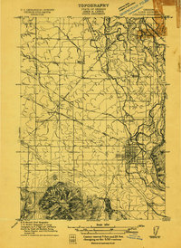
 1914 Oregon City1914 Print · USGSThe Willamette Valley at the start of the twentieth century was a landscape of rapid rail expansion and river-based industry. Researchers can trace early rural life through Wichita School and Lions Mill, or explore the growth of Oswego and Milwaukie.4 unique versions available
 - 1914 Map of Seiad, 1957 Print
 1914 Seiad1957 Print · USGSSiskiyou County's rugged borderlands are documented here just before the First World War, showing a landscape of remote mines and river settlements. Genealogists and historians can trace family outposts like Johnsons Dairy, old schoolhouses, and active mining works such as the Blue Ledge Mine.
 - 1915 Map of Rickreall
 1915 Rickreall1915 Print · USGSPolk County at the start of the Great War reveals a landscape defined by diverging rail lines and early orchards. Genealogists and historians can trace the foundations of Rickreall, locate the old Greenwood School, and follow the Southern Pacific tracks through Gerlinger.
 - 1915 Map of Hillsboro
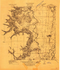
 1915 Hillsboro1915 Print · USGSThe Tualatin Valley and the confluence of the Columbia and Willamette rivers are shown here at the peak of the electric rail era. Researchers can trace historic family schoolhouses like Mason Hill School and vanished landings such as Blurock Landing.
 - 1915 Map of Pine
 1915 Pine1915 Print · USGSEastern Oregon was a hub of gold mining and river commerce in the early twentieth century. Researchers can trace the legacy of pioneer families and industry at the Sanger Mine, follow the old Oregon-Washington Railroad, or locate the Mineral P O along the river.3 unique versions available
 - 1915 Map of Eola
 1915 Eola1915 Print · USGSThe Willamette Valley at the start of the twentieth century reveals a landscape defined by the growth of Salem and its major state institutions. Researchers can trace early railroad lines like the Oregon Electric Railway and find vanished rural schools including Peanut School and Mountainview School.
 - 1915 Map of Sidney
 1915 Sidney1915 Print · USGSMarion County's riverfront and rail corridors are captured here just before the First World War, showing a landscape of mills and tight-knit rural schools. Researchers can locate stops on the Oregon Electric line and local landmarks like Sidney Mills and Looney Butte.
 - 1915 Map of Wallulah
 1915 Wallulah1915 Print · USGSThe convergence of the Snake and Columbia rivers in the mid-1910s reveals a landscape defined by steam power and irrigation. Genealogists and rail historians can trace early settlements like Attalia and Two Rivers alongside the path of the Oregon-Washington RR & Nav Co.
 - 1916 Map of Tualatin
 1916 Tualatin1916 Print · USGSThe northern Willamette Valley in the mid-1910s is a landscape of orchards and rail spurs, where river ferries still compete with new electric lines. Trace family roots at Champoeg Monument or explore old school sites like Grabel School and St Pauls School.5 unique versions available
 - 1916 Map of Arlington
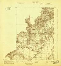
 1916 Arlington1916 Print · USGSThe Columbia River frontier of the mid-1910s reveals a world where the Oregon Trail and early railroads met the water. Genealogists can trace family roots through rural landmarks like Stegeman Ranch, Shutler, and the Locust Grove School.4 unique versions available
Showing maps 1-25 of 40
Top cities of Oregon
- Portland historical maps
- Eugene historical maps
- Salem historical maps
- Gresham historical maps
- Bend historical maps
- Hillsboro historical maps
See more
Top counties of Oregon
- Multnomah County historical maps
- Washington County historical maps
- Clackamas County historical maps
- Lane County historical maps
- Marion County historical maps
- Jackson County historical maps
See more
Frequently asked questions
- What are the different types of historical maps available for Oregon?
- What is the oldest map of Oregon?
- Where can I purchase historical maps of Oregon for my home or office?
- Where can I download high-res historical maps of Oregon?
- Are there historical topographic maps available for Oregon?
- Is there historical aerial imagery available for Oregon?
- Where are historical maps of Oregon sourced from?