1900s (20th Century) Maps of Oregon
Explore 3,305 historic maps of Oregon from the 1900s (20th Century). These maps offer a rare glimpse into what life looked like during the 1900s — showing old roads, neighborhoods, homes, and landmarks that have changed or disappeared over time.
Whether you're researching your family's past, planning a metal detecting trip, or studying how Oregon's landscape evolved across the 1900s, these high-resolution maps are a powerful tool for exploring the history of this region.
- Focus on a specific era: All maps on this page are from the 1900s, giving you a focused view of this time period.
- See what’s changed: Compare century-old streets, trails, and buildings to today's modern landscape using overlays and satellite layers.
- Research with precision: Use these maps for genealogy, historical research, land use analysis, or educational projects.
- View, download, or print: Maps are fully viewable online in high resolution, and can be downloaded or printed for your own records.
Start exploring Oregon's history through authentic maps from the 1900s. This is your window into the past.
Oregon maps
(3,305)- 1900 Map of Roseburg
 1900 Roseburg1900 Print · USGSDouglas County at the turn of the century shows a landscape transitioning through the arrival of the Southern Pacific railroad. Genealogists and local historians can trace early river crossings like Lone Rock Ferry and explore the layouts of Oakland, Winchester, and Myrtle Creek.5 unique versions available
 - 1900 Map of Coos Bay
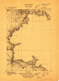
 1900 Coos Bay1900 Print · USGSThe Oregon coast at the turn of the century was a landscape of tide-water towns and river commerce centered on the massive Coos Bay inlet. Genealogists and local historians can trace early settlements like Marshfield, follow the Randolph Trail, and locate forgotten landings along Isthmus Slough.7 unique versions available
 - 1901 Map of Baker City
 1901 Baker City1901 Print · USGSBaker County at the close of the century was a landscape of bustling rail hubs and active mining districts. Genealogists and historians can trace early settlements like Auburn, follow the Sumpter Valley Railroad line, or locate specific operations like the Flagstaff Mine.4 unique versions available
 - 1901 Map of Sumpter
 1901 Sumpter1901 Print · USGSThe Oregon gold boom is at its peak in this turn-of-the-century survey of the high Elkhorn Range. Miners and genealogists can trace the early rail corridor of the Sumpter Valley River and locate historic camps like Bourne, Belleview, and French Diggings.4 unique versions available
 - 1903 Map of Port Orford
 1903 Port Orford1903 Print · USGSCoastal Curry County at the start of the twentieth century was a landscape of remote mountain outposts and rugged river valleys. Genealogists and historians can trace early settlements like Illahe, Agness, and Frankport, or locate landmarks such as Mountain Well and Floras Lake.7 unique versions available
 - 1904 Map of Riddle
 1904 Riddle1904 Print · USGSSouthern Oregon's mining and railroad corridor is captured here at the start of the twentieth century. Genealogists can trace family footprints through early settlements like Riddles and Galesville or locate specific claims like the Placer Star Mine.5 unique versions available
 - 1905 Map of Portland
 1905 Portland1905 Print · USGSGreater Portland and Vancouver are seen here during the era of the Lewis and Clark Exposition, when river traffic and early electric rail lines defined the region. Researchers can locate the Lewis and Clark Centennial Exposition, the historic Vancouver Barracks, and Munday's Ferry.8 unique versions available
 - 1906 Map of Mitchell Butte
 1906 Mitchell Butte1906 Print · USGSEastern Oregon's high desert was being redefined by irrigation and ranching at the turn of the century. Genealogists and historians can trace early water rights through the Farmers Ditch network or locate remote family outposts like Isaacs Ranch and Prices Ranch.3 unique versions available
 - 1906 Map of Telocaset
 1906 Telocaset1906 Print · USGSEastern Oregon at the peak of its railroad and ranching era features a landscape of thriving valley towns and high forest reserves. Genealogists and local historians can trace early settlements like Union and Cove, or locate long-standing landmarks such as Hot Lake and Medical Springs.3 unique versions available
 - 1906 Map of Blalock Island, 1954 Print
 1906 Blalock Island1954 Print · USGSThe Columbia River corridor in the early twentieth century served as a vital nexus for Pacific Northwest rail and river trade. Researchers can trace the routes of three major railroads and locate early settlements and landmarks like Irrigon, Blalock Island, and Castle Rock.2 unique versions available
 - 1908 Map of Blalock Island
 1908 Blalock Island1908 Print · USGSThe Columbia River frontier of Oregon and Washington is captured here in the years before massive dam projects altered the basin. Researchers can trace the path of the Emigrant Road and locate early settlements like Douglas Morgan P.O., Cecil, and Irrigon.3 unique versions available
 - 1908 Map of Umatilla
 1908 Umatilla1908 Print · USGSEastern Oregon at the turn of the century shows a landscape being transformed by early irrigation and competing rail lines. Genealogists and researchers can trace the growth of Hermiston, Echo, and Pine City or follow the path of the Stage Road and the Furnish Ditch.3 unique versions available
 - 1908 Map of Ironside Mountain
 1908 Ironside Mountain1908 Print · USGSEastern Oregon ranching and timber frontiers come alive in this survey of the Blue Mountains region at the turn of the century. Researchers can trace early family holdings like Tureman's Ranch and Hunter's Ranch, or locate the historic Otis Sawmill.2 unique versions available
 - 1908 Map of Grants Pass
 1908 Grants Pass1908 Print · USGSThe Rogue River valley and Siskiyou Mountains are shown here during a peak era of mineral extraction and rail expansion. Researchers can trace historic claims like the Granite Hill Mine or find early settlements such as Woodville and Wilderville before modern development altered the landscape.5 unique versions available
 - 1909 Map of Harrisburg
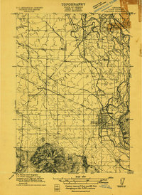
 1909 Harrisburg1909 Print · USGSThe Willamette Valley at the end of the first decade of the twentieth century shows a landscape tied to both river and rail. Researchers can trace the early road network like Halsey Road and locate numerous local landmarks like Ingrams Ferry or the Muddy School.
 - 1909 Map of Rowland
 1909 Rowland1909 Print · USGSLinn County agriculture and rural life are captured in the early 1900s, showing a landscape of scattered schoolhouses and rail lines. You can trace early family sites near the Southern Pacific Railroad and locate community landmarks like Rowland and Cherry Center School.
 - 1909 Map of Elmira
 1909 Elmira1909 Print · USGSLane County at the turn of the century shows a landscape of river-bottom farms and emerging rail towns. Genealogists and historians can locate early landmarks like Perkins Mill, the Redonk School, and the original footprints of Elmira and Alvadore.
 - 1910 Map of Eugene
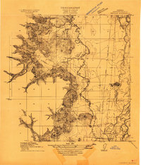
 1910 Eugene1910 Print · USGSThe upper Willamette Valley comes to life in the years before the Great War, centered on the growing campus of the University of Oregon. Genealogists can trace family footprints across dozens of local school districts like Santa Clara and Deadman, or follow the early tracks of the Oregon Electric RR.2 unique versions available
 - 1911 Map of Brownsville
 1911 Brownsville1911 Print · USGSBrownsville and the surrounding Linn County valley floor appear here during the early twentieth century. Genealogists and local historians can trace the early rail corridor of the Southern Pacific and locate rural landmarks like Rock Hill School and Warren School.
 - 1911 Map of Lebanon
 1911 Lebanon1911 Print · USGSLinn County agriculture and rail travel are in full bloom here in the decade before the First World War. Researchers can trace the early foundations of Lebanon or locate specific country schoolhouses like Gore School and Stoltz Hill School near the base of Peterson Butte.
 - 1911 Map of Monroe
 1911 Monroe1911 Print · USGSThe Willamette Valley foothills meet the river bottomlands in the early twentieth century near the Benton and Lane county border. Genealogists and researchers can trace early settlements at Bellfountain and Alpine or locate rural landmarks like Irish Bend School and Ferguson Bridge.
 - 1911 Map of Tangent
 1911 Tangent1911 Print · USGSLinn County’s fertile valley was a hive of rail activity and rural education in the early twentieth century. Genealogists can locate family landmarks like Oak Creek Church and several rural schoolhouses, including Flunow School and Midway School.
 - 1911 Map of Boring
 1911 Boring1911 Print · USGSClackamas County was a patchwork of small farming communities and emerging rail hubs in the decade before the First World War. Researchers can trace the early footprints of settlements like Boring and Gresham, alongside family landmarks such as Peterson Crossroads and Sycamore School.
 - 1911 Map of Inavale
 1911 Inavale1911 Print · USGSBenton County farm life and rural school districts are captured here in the decade before the First World War. Genealogists can trace family landmarks and neighborhood hubs like McFarland Chapel, Beaver Creek School, and the lakeside environment around Winkle Lake.
 - 1912 Map of Jefferson
 1912 Jefferson1912 Print · USGSThe Willamette Valley at the height of the pre-war rail era shows a landscape of river-bend towns and rural school districts. Genealogists can locate family lands near Millersburg or trace the routes of the Oregon Electric and Corvallis and Eastern railroads.
Showing maps 1-25 of 3,305
Top cities of Oregon
- Portland historical maps
- Eugene historical maps
- Salem historical maps
- Gresham historical maps
- Bend historical maps
- Hillsboro historical maps
See more
Top counties of Oregon
- Multnomah County historical maps
- Washington County historical maps
- Clackamas County historical maps
- Lane County historical maps
- Marion County historical maps
- Jackson County historical maps
See more
Frequently asked questions
- What are the different types of historical maps available for Oregon?
- What is the oldest map of Oregon?
- Where can I purchase historical maps of Oregon for my home or office?
- Where can I download high-res historical maps of Oregon?
- Are there historical topographic maps available for Oregon?
- Is there historical aerial imagery available for Oregon?
- Where are historical maps of Oregon sourced from?