1930s Maps of Oregon
Explore 30 historic maps of Oregon from the 1930s. These maps offer a rare glimpse into what life looked like during the 1930s — showing old roads, neighborhoods, homes, and landmarks that have changed or disappeared over time.
Whether you're researching your family's past, planning a metal detecting trip, or studying how Oregon's landscape evolved across the 1930s, these high-resolution maps are a powerful tool for exploring the history of this region.
- Focus on a specific era: All maps on this page are from the 1930s, giving you a focused view of this time period.
- See what’s changed: Compare century-old streets, trails, and buildings to today's modern landscape using overlays and satellite layers.
- Research with precision: Use these maps for genealogy, historical research, land use analysis, or educational projects.
- View, download, or print: Maps are fully viewable online in high resolution, and can be downloaded or printed for your own records.
Start exploring Oregon's history through authentic maps from the 1930s. This is your window into the past.
Oregon maps
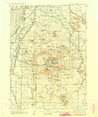
(30)- 1930 Map of Maiden Peak
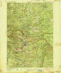
 1930 Maiden Peak1930 Print · USGSThe high volcanic plateau of central Oregon is captured in the early 1930s as a landscape of new reservoirs and forest outposts. Genealogists and historians can trace family-named sites like Caldwell Ranch or follow early travel routes like Century Drive and the Southern Pacific rail line.3 unique versions available
 - 1930 Map of Mt. Jefferson
 1930 Mt. Jefferson1930 Print · USGSThe Oregon Cascades were a frontier of early forest management and tribal lands during the late 1920s. Researchers can locate remote administrative outposts like the Lemiti Ranger Sta, trace the thermal waters of Breitenbush Hot Sprs, and explore the high meadows of Independence Prairie.3 unique versions available
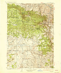
 - 1930 Map of Dufur, 1945 Print
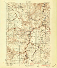
 1930 Dufur1945 Print · USGSWasco County at the start of the 1930s shows a transition from pioneer wagon routes to a rail-and-ranch economy. Genealogists can locate dozens of country schools like Ireland Sch and early infrastructure including the Barlow Road and the Great Southern Railroad.2 unique versions available
 - 1931 Map of Madras
 1931 Madras1931 Print · USGSCentral Oregon ranching and rail life come into focus in the late twenties, centering on the Warm Springs Agency. Trace the river-level rail stops at Mecca and Kaskela or locate early rural schoolhouses like New Era Sch and Lyle Gap Sch.2 unique versions available
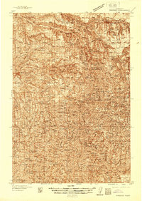
 - 1931 Map of Newberry Crater, 1960 Print
 1931 Newberry Crater1960 Print · USGSDeschutes County was a landscape of timber camps and volcanic wonders in the early 1930s, during a period of heavy logging. Researchers can trace the Logging RR networks, find the Vandevert Sch, and locate industrial sites like Brooks-Scanlon Camp 3.
 - 1932 Map of Three Sisters
 1932 Three Sisters1932 Print · USGSThe eastern Cascades and the high desert meet in the early 1930s as the regional highway system begins to pierce the mountains. Genealogists and historians can trace early settlements like Camp Polk and Sisters or locate old forest landmarks such as Camp Sherman and Black Butte.3 unique versions available
 - 1932 Map of Dayville, 1958 Print
 1932 Dayville1958 Print · USGSCentral Oregon ranching and timber frontiers are captured here in the early 1930s, documenting a remote landscape of high plateaus and river valleys. Genealogists and historians can locate family landmarks like Congleton Ranch, the ruins of Camp Watson, and early rural school sites like Beaver Creek Sch.
 - 1934 Map of Maiden Peak
 1934 Maiden Peak1934 Print · USGSCentral Oregon’s high desert and timberlands are captured here in the early thirties, centered on the Crane Prairie Reservoir. Researchers can find isolated outposts like Caldwell Ranch, the Log Cabin, and Lapine at the highway junction.3 unique versions available
 - 1934 Map of Dufur
 1934 Dufur1934 Print · USGSWasco County during the mid-1930s reveals a landscape of high plateaus and river canyons shaped by pioneering roads and rail. Genealogists can trace family roots through a dense network of rural schoolhouses like Kelly Sch and Wolf Run Sch, or follow the path of the historic Barlow Road.2 unique versions available
 - 1934 Map of Mc Kenzie Bridge
 1934 Mc Kenzie Bridge1934 Print · USGSThe Cascades in the mid-1930s were a network of forest guard stations, remote ranches, and early mountain resorts. Genealogists and historians can locate family landmarks such as Sims Ranch and Hardy Cabin or trace the early developments at Belknap Springs.
 - 1934 Map of The Dalles
 1934 The Dalles1934 Print · USGSThe Columbia River Gorge in the early thirties reveals a complex network of rapids and river engineering before the completion of major modern dams. Local historians can trace early school districts like Threemile Sch and family landmarks such as Clancy Ranch or Petersburg.4 unique versions available
 - 1934 Map of Troutdale
 1934 Troutdale1934 Print · USGSThe Columbia River shoreline and the wooded hills of Clark County come alive in this mid-1930s survey of the riverfront. Researchers can trace early rural life through Washougal and local landmarks like Fern Prairie Grange, Lackamas Lake, and the Silver Star Mine.
 - 1935 Map of Lowell
 1935 Lowell1935 Print · USGSIn the mid-1930s, this region of the Willamette foothills was a busy landscape of timber and rail. Researchers can trace rural school districts like Unity Sch, small post offices at Fall Creek PO, and the path of the Southern Pacific railroad.
 - 1935 Map of Chemult
 1935 Chemult1935 Print · USGSUpper Klamath County in the mid-1930s was a landscape defined by industrial logging camps and high-desert rail sidings. Researchers can locate vanished timber operations like Pelican Bay Lumber Co Camp No 2 and remote outposts such as Rosedale and Paunina.5 unique versions available
 - 1935 Map of Pendleton
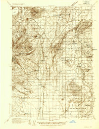
 1935 Pendleton1935 Print · USGSPendleton and the surrounding Umatilla River valley are captured in the mid-1930s as the region solidified its role as a transportation and agricultural hub. Genealogists can locate numerous named rural schoolhouses such as Campbell Sch and North Yoakum Sch, or trace family sites near the Umatilla Indian Reservation and Cabbage Hill.3 unique versions available
 - 1935 Map of Newberry Crater
 1935 Newberry Crater1935 Print · USGSDeschutes County in the mid-1930s is a landscape of volcanic wonders and active timber camps. Researchers can locate remote logging outposts like Brooks-Scanlon Camp 2, rural schools including Little River Sch, and geological landmarks like Lava River Cave.3 unique versions available
 - 1936 Map of Dayville
 1936 Dayville1936 Print · USGSIn the early 1930s, this portion of Central Oregon was a landscape of high timber and remote cattle ranches along the John Day River. Researchers can trace the era's ranching families at Dexter Ranch and Mills Ranch, or find the location of the Old Bear Creek Sawmill and Fort Camp Watson.3 unique versions available
 - 1937 Map of Pomeroy
 1937 Pomeroy1937 Print · USGSGarfield and Columbia Counties appear in the late thirties as a patchwork of upland farms and forest outposts. Genealogists and historians can locate rural landmarks like Pataha Cem, the Tucannon Guard Sta, and various country schools including Pine Grove Sch.3 unique versions available
 - 1937 Map of Nehalem, 1954 Print
 1937 Nehalem1954 Print · USGSThe Tillamook coast in the late thirties shows a landscape of thriving seaside resorts and industrial rail lines. Genealogists and historians can trace the foundations of Bayocean and Garibaldi or locate the long-standing Nehalem Fish Hatchery and local mills.
 - 1937 Map of Enright, 1956 Print
 1937 Enright1956 Print · USGSTillamook County's interior mountains are shown in the late 1930s, an era when the Southern Pacific railroad served as the lifeline for canyon settlements. Researchers can trace the old rail stops at Enright and Belfort or locate the Fish Hatchery near Lees Camp.
 - 1938 Map of Cape Disappointment
 1938 Cape Disappointment1938 Print · USGSThe Long Beach Peninsula in the late 1930s was a bustling landscape of oyster docks, coastal ranches, and military outposts. Genealogists can trace family holdings like the Loomis Ranch or find local landmarks including the Moby Dick Hotel and Fort Canby.
 - 1938 Map of Medford
 1938 Medford1938 Print · USGSIn the 1930s, the Rogue River Valley served as a thriving hub for southern Oregon mining and transit. Genealogists and historians can trace old homesteads and landmarks like the Willow Springs Cem, the Millionaire Mine, and the Bybee Bridge.3 unique versions available
 - 1938 Map of Fort Columbia, 1957 Print
 1938 Fort Columbia1957 Print · USGSCoastal Washington and the Columbia River estuary appear in the late 1930s, showing a landscape of maritime defense and family-run ranches. Trace historic local landmarks like the Fort Columbia Military Reservation, the Peaceful Hill Cem, and the U S Quarantine Station.2 unique versions available
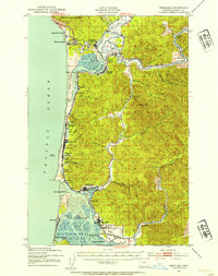
 - 1939 Map of Astoria
 1939 Astoria1939 Print · USGSThe Columbia River mouth and Oregon coast appear here just before the Second World War, showing a landscape of maritime defense and timber industry. Genealogists can locate family-named landmarks and rural hubs like Netel Grange, Soldiers Cem, and Youngs River Falls Sch.
 - 1939 Map of Saddle Mountain, 1941 Print
 1939 Saddle Mountain1941 Print · USGSCoastal Oregon at the end of the 1930s is a landscape of dense timber and remote outposts. Genealogists and historians can trace the early road networks connecting Jewell and Elsie, or locate the C C C Camp Jewell and the Lewis and Clark GS deep in the hills.
Showing maps 1-25 of 30
Top cities of Oregon
- Portland historical maps
- Eugene historical maps
- Salem historical maps
- Gresham historical maps
- Bend historical maps
- Hillsboro historical maps
See more
Top counties of Oregon
- Multnomah County historical maps
- Washington County historical maps
- Clackamas County historical maps
- Lane County historical maps
- Marion County historical maps
- Jackson County historical maps
See more
Frequently asked questions
- What are the different types of historical maps available for Oregon?
- What is the oldest map of Oregon?
- Where can I purchase historical maps of Oregon for my home or office?
- Where can I download high-res historical maps of Oregon?
- Are there historical topographic maps available for Oregon?
- Is there historical aerial imagery available for Oregon?
- Where are historical maps of Oregon sourced from?