1940s Maps of South Dakota
Explore 9 historic maps of South Dakota from the 1940s. These maps offer a rare glimpse into what life looked like during the 1940s — showing old roads, neighborhoods, homes, and landmarks that have changed or disappeared over time.
Whether you're researching your family's past, planning a metal detecting trip, or studying how South Dakota's landscape evolved across the 1940s, these high-resolution maps are a powerful tool for exploring the history of this region.
- Focus on a specific era: All maps on this page are from the 1940s, giving you a focused view of this time period.
- See what’s changed: Compare century-old streets, trails, and buildings to today's modern landscape using overlays and satellite layers.
- Research with precision: Use these maps for genealogy, historical research, land use analysis, or educational projects.
- View, download, or print: Maps are fully viewable online in high resolution, and can be downloaded or printed for your own records.
Start exploring South Dakota's history through authentic maps from the 1940s. This is your window into the past.
South Dakota maps
(9)- 1940 Map of Iona, 1958 Print
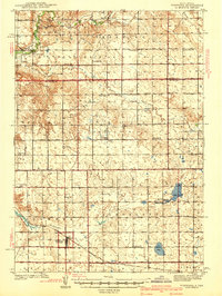
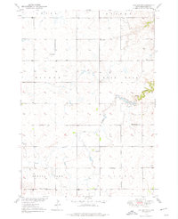
 1940 Iona1958 Print · USGSIn the early 1940s, the Missouri and White Rivers shaped life across South Dakota's Lyman and Brule counties. Genealogists can trace nearly twenty rural schoolhouses and cemeteries like Iona Cem, alongside landmarks such as Twilight Butte and the settlement of Iona.
 - 1941 Map of Pukwana
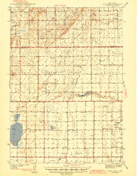
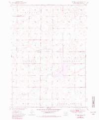
 1941 Pukwana1941 Print · USGSBrule County farming and the Crow Creek Indian Reservation meet in this pre-war survey of central South Dakota. Researchers can locate nearly twenty individual schoolhouses, such as Victory Sch and Olson Sch, alongside the Vega Cem and Row Creek Cem.
 - 1941 Map of Kimball North
 1941 Kimball North1941 Print · USGSBrule County's agricultural heartland is documented here on the eve of the Second World War, showing a landscape defined by rail and rural schools. Genealogists can trace family footprints near Kimball or locate specific country schools like Fagerhaug Sch and Brooks Sch.
 - 1942 Map of Crow Lake
 1942 Crow Lake1942 Print · USGSThe South Dakota prairie of Jerauld and Aurora Counties is captured here in the early 1940s, showing a landscape defined by small townships and artesian wells. Genealogists can trace a dense network of rural landmarks, including Underwood Ch, Union Cem, and numerous schoolhouses like Willow Bend Sch.3 unique versions available
 - 1944 Map of Iona
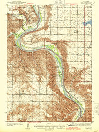 1944 Iona1944 Print · USGSLyman County in the early 1940s reveals a landscape of isolated homesteads and river-bottom farms along the Missouri River. Genealogists and local historians can trace family roots through numerous country schools like Cable Sch and markers such as Iona Cem and Peterson.2 unique versions available
 - 1949 Map of Ree Heights NW, 1967 Print
 1949 Ree Heights NW1967 Print · USGSHand County is captured here in the late 1940s, highlighting a landscape of rural schoolhouses and water resources. Local historians can trace the foundations of the community at Van Zee Sch, NE Riverside Sch, and the Flowing Well sites near Lake Louise.
 - 1949 Map of Vayland SE, 1976 Print
 1949 Vayland SE1976 Print · USGSHand County townships are mapped here in the late 1940s, showing a landscape defined by prairie agriculture and rural school districts. Genealogists can trace early homestead life through the locations of Rose Hill Ch, Cem, and Rowen Sch.
 - 1949 Map of Vayland SW, 1976 Print
 1949 Vayland SW1976 Print · USGSHand County prairie life is documented here during the late 1940s, showing a landscape defined by township grids and rural school districts. Researchers can pinpoint several local landmarks like Spring Lake, Pleasant Valley Ch, and Horseshoe Bend Sch.
 - 1949 Map of Mitchell Lake, 1981 Print
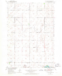
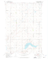
 1949 Mitchell Lake1981 Print · USGSHyde County, South Dakota, is captured here in the late 1940s as part of the Missouri River Basin development program. Researchers can locate vanished rural landmarks like South Illinois Sch, Edwin Ch, and Pleasant View Cem.
End of results
Showing maps 1-9 of 9
Top cities of South Dakota
- Sioux Falls historical maps
- Rapid City historical maps
- Aberdeen historical maps
- Watertown historical maps
- Brookings historical maps
- Mitchell historical maps
See more
Top counties of South Dakota
- Minnehaha County historical maps
- Pennington County historical maps
- Lincoln County historical maps
- Brown County historical maps
- Brookings County historical maps
- Codington County historical maps
See more
Frequently asked questions
- What are the different types of historical maps available for South Dakota?
- What is the oldest map of South Dakota?
- Where can I purchase historical maps of South Dakota for my home or office?
- Where can I download high-res historical maps of South Dakota?
- Are there historical topographic maps available for South Dakota?
- Is there historical aerial imagery available for South Dakota?
- Where are historical maps of South Dakota sourced from?