1930s Maps of South Dakota
Explore 9 historic maps of South Dakota from the 1930s. These maps offer a rare glimpse into what life looked like during the 1930s — showing old roads, neighborhoods, homes, and landmarks that have changed or disappeared over time.
Whether you're researching your family's past, planning a metal detecting trip, or studying how South Dakota's landscape evolved across the 1930s, these high-resolution maps are a powerful tool for exploring the history of this region.
- Focus on a specific era: All maps on this page are from the 1930s, giving you a focused view of this time period.
- See what’s changed: Compare century-old streets, trails, and buildings to today's modern landscape using overlays and satellite layers.
- Research with precision: Use these maps for genealogy, historical research, land use analysis, or educational projects.
- View, download, or print: Maps are fully viewable online in high resolution, and can be downloaded or printed for your own records.
Start exploring South Dakota's history through authentic maps from the 1930s. This is your window into the past.
South Dakota maps
(9)- 1934 Map of Canning
 1934 Canning1934 Print · USGSCentral South Dakota comes to life in the mid-1930s as the Missouri River valley supports a network of ranches and small schools. Genealogists can trace family landmarks like Petrus Ranch or locate local centers including Elm Grove Sch and the Holy Name Chapel.
 - 1935 Map of Reva
 1935 Reva1935 Print · USGSHarding County ranching country and the rugged Slim Buttes region are captured here in the mid-1930s. Genealogists and local historians can trace family-named landmarks like Turkey Track Ranch and early post offices at Reva, Ludlow, and Glenlevit.
 - 1935 Map of Hoover
 1935 Hoover1935 Print · USGSThe high plains of South Dakota in the mid-thirties reveal a landscape of remote ranching outposts and conservation lands. Genealogists and researchers can trace family-named landmarks like JB Ranch and early settlements such as Hoover and Murchison.
 - 1935 Map of Harding
 1935 Harding1935 Print · USGSNorthwestern South Dakota in the mid-1930s was a vast expanse of range land where local life centered on the Custer National Forest and isolated outposts. Genealogists and historians can trace the early road networks and rural hubs like Harding, Gustave, and Mud Butte along the banks of the North Fork Moreau River.
 - 1935 Map of Buffalo
 1935 Buffalo1935 Print · USGSHarding County in the mid-1930s remains a wide-open landscape where the early road system connects remote prairie outposts. Genealogists and historians can locate early settlements like Camp Crook and Bullock or trace the drainages of the Little Missouri River and South Fork Grand River.
 - 1935 Map of Chamberlain, 1975 Print
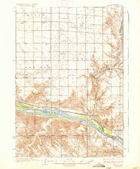
 1935 Chamberlain1975 Print · USGSMid-century South Dakota river life centers on the Missouri crossing between Chamberlain and Oacoma during the mid-thirties. Genealogists can locate numerous country schools like Pleasant View Sch and historical sites such as the CCC Camp.
 - 1937 Map of Canning
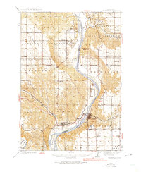
 1937 Canning1937 Print · USGSHughes County ranching and river life are captured here in the mid-1930s as the Missouri River flowed freely past historic islands and rail sidings. Genealogists can locate family landmarks like Pietrus Ranch, Finder Ranch, and numerous country schools such as Pleasantview Sch.3 unique versions available
 - 1937 Map of Oahe
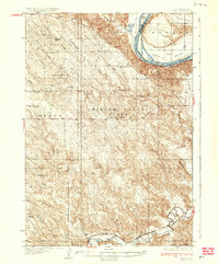 1937 Oahe1937 Print · USGSStanley County ranching and river life are captured here in the mid-thirties before the Missouri was transformed by modern dams. Genealogists can locate family-named landmarks like Madison Ranch and rural schoolhouses such as Riverview Sch or Willow Creek Butte Sch.3 unique versions available
 - 1939 Map of Chamberlain
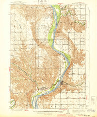 1939 Chamberlain1939 Print · USGSChamberlain and Oacoma face one another across the Missouri River in the late thirties, just as the region transitioned into the modern era. Genealogists and researchers can locate numerous country schools and churches, including St Albans Ch, Grace Mission Sch, and Riverview Cem.2 unique versions available
End of results
Showing maps 1-9 of 9
Top cities of South Dakota
- Sioux Falls historical maps
- Rapid City historical maps
- Aberdeen historical maps
- Watertown historical maps
- Brookings historical maps
- Mitchell historical maps
See more
Top counties of South Dakota
- Minnehaha County historical maps
- Pennington County historical maps
- Lincoln County historical maps
- Brown County historical maps
- Brookings County historical maps
- Codington County historical maps
See more
Frequently asked questions
- What are the different types of historical maps available for South Dakota?
- What is the oldest map of South Dakota?
- Where can I purchase historical maps of South Dakota for my home or office?
- Where can I download high-res historical maps of South Dakota?
- Are there historical topographic maps available for South Dakota?
- Is there historical aerial imagery available for South Dakota?
- Where are historical maps of South Dakota sourced from?