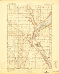
1910s Maps of South Dakota
Explore 11 historic maps of South Dakota from the 1910s. These maps offer a rare glimpse into what life looked like during the 1910s — showing old roads, neighborhoods, homes, and landmarks that have changed or disappeared over time.
Whether you're researching your family's past, planning a metal detecting trip, or studying how South Dakota's landscape evolved across the 1910s, these high-resolution maps are a powerful tool for exploring the history of this region.
- Focus on a specific era: All maps on this page are from the 1910s, giving you a focused view of this time period.
- See what’s changed: Compare century-old streets, trails, and buildings to today's modern landscape using overlays and satellite layers.
- Research with precision: Use these maps for genealogy, historical research, land use analysis, or educational projects.
- View, download, or print: Maps are fully viewable online in high resolution, and can be downloaded or printed for your own records.
Start exploring South Dakota's history through authentic maps from the 1910s. This is your window into the past.
South Dakota maps
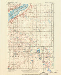
(11)- 1913 Map of Newell
 1913 Newell1913 Print · USGSButte and Meade Counties were being reshaped by new rails and irrigation projects in the decade before the Great War. Researchers can trace the path of the Chicago and Northwestern Ry and locate early settlements like Newell, Vale, and Station Elm.2 unique versions available
 - 1915 Map of Spearfish
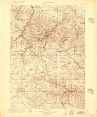
 1915 Spearfish1915 Print · USGSLawrence County in the early twentieth century is a landscape of gold mining camps and mountain railroads. Genealogists and historians can trace the foundations of Lead and Spearfish, or find now-quiet locations like Homestake Camp and Carbonate.2 unique versions available
 - 1915 Map of Sturgis
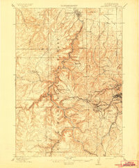
 1915 Sturgis1915 Print · USGSThe Black Hills were a hub of mining and military activity in the early twentieth century. Researchers can trace the rail lines of the Chicago and Northwestern and locate specialized sites like the Golden Crest Mine and the Fort Meade Military Reservation.2 unique versions available
 - 1915 Map of White Rock, 1954 Print
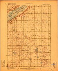
 1915 White Rock1954 Print · USGSThe tri-state border region of the Dakotas and Minnesota comes alive in the early twentieth century as a hub of rail lines and prairie schools. Trace early settlements like White Rock and Rosholt or locate family landmarks such as Knutson School and Teare School.2 unique versions available
 - 1916 Map of Deadwood
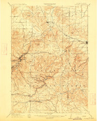
 1916 Deadwood1916 Print · USGSThe Black Hills mining district at the peak of its early industrial era shows a dense network of rail and timber camps. Researchers can trace the narrow-gauge C B & Q RR lines to the Queen Bee Mine and the Fort Meade Military Reservation.3 unique versions available
 - 1916 Map of Peever, 1954 Print
 1916 Peever1954 Print · USGSThe borderlands of South Dakota and Minnesota come alive in this survey of the early twentieth century. Genealogists and local historians can trace the paths of the Great Northern railroad and locate rural landmarks like Windom School, Peever, and the Erdman School.
 - 1916 Map of Beardsley, 1968 Print
 1916 Beardsley1968 Print · USGSWestern Minnesota and the South Dakota border are captured here during the height of the steam-rail era. Genealogists and researchers can trace dozens of early rural schoolhouses, including Hilo School and Twingrove School, alongside the Great Northern line.2 unique versions available
 - 1917 Map of New Effington
 1917 New Effington1917 Print · USGSThe Dakota borderlands come alive in this survey from the mid-1910s, capturing the early rail-and-reservation era. Genealogists can locate family-named landmarks like Shafts School and Wymen School along the Minneapolis St Paul and Sault Ste Marie line.2 unique versions available
 - 1918 Map of Peever
 1918 Peever1918 Print · USGSThe borderlands of South Dakota and Minnesota are captured here during the First World War, centered on the strategic divide at Browns Valley. Genealogists and local historians can trace rural school locations like Morehead School and Becker School alongside the tracks of the Great Northern railroad.4 unique versions available
 - 1918 Map of White Rock
 1918 White Rock1918 Print · USGSThe tri-state borderlands of South Dakota, Minnesota, and North Dakota are frozen in time just before the end of the Great War. Researchers can trace the Sisseton and Wahpeton Indian Reservation boundary or locate early schools like Teare School and Knutson School.4 unique versions available
 - 1918 Map of Beardsley
 1918 Beardsley1918 Print · USGSWestern Minnesota and the South Dakota borderlands appear here during the height of the steam rail era. Genealogists can trace family footprints across dozens of local districts, from Round Mound School to the village streets of Beardsley.3 unique versions available
End of results
Showing maps 1-11 of 11
Top cities of South Dakota
- Sioux Falls historical maps
- Rapid City historical maps
- Aberdeen historical maps
- Watertown historical maps
- Brookings historical maps
- Mitchell historical maps
See more
Top counties of South Dakota
- Minnehaha County historical maps
- Pennington County historical maps
- Lincoln County historical maps
- Brown County historical maps
- Brookings County historical maps
- Codington County historical maps
See more
Frequently asked questions
- What are the different types of historical maps available for South Dakota?
- What is the oldest map of South Dakota?
- Where can I purchase historical maps of South Dakota for my home or office?
- Where can I download high-res historical maps of South Dakota?
- Are there historical topographic maps available for South Dakota?
- Is there historical aerial imagery available for South Dakota?
- Where are historical maps of South Dakota sourced from?