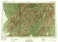
1951 Map of Goodnews
USGS Topo · Published 1953About this map
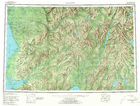
Kwinhagak and the settlement of Platinum anchor the coastal fringes of this southwest Alaska landscape, where the Kilbuck Mountains and Ahklun Mountains dominate the interior. The map documents a transition in resource extraction and subsistence, showing a Placer Mine near Goodnews Bay and several Cabins and seasonal sites along major drainages like the Kanektok River and Togiak River. Large glacially carved bodies of water, including Lake Nerka and Lake Aleknagik, define the eastern edge of the survey, while the boundary between the Fourth Judicial Division and the Third Judicial Division cuts through the high peaks. The presence of Togiak Village and Kashiagamiut reflects the established presence of communities along the river mouths and sheltered bays in the early 1950s.
Find a feature on this map
49 named features on this map. Tap any name to fly to it.
Don’t see what you’re looking for? This feature index may not catch every label — zoom into the map to look around manually.
Map Details
Editions of this 1951 Goodnews Map
6 editions found

Other maps of this area

1945 · Nushagak Bay
USGS Topo · 1:250,000

1947 · Hagemeister Island D-2
USGS Topo · 1:63,360

1948 · Hagemeister Island D-3
USGS Topo · 1:63,360

1948 · Nushagak Bay D-4
USGS Topo · 1:63,360

1948 · Nushagak Bay D-3
USGS Topo · 1:63,360

1949 · Nushagak Bay
USGS Topo · 1:250,000

1950 · Bethel
USGS Topo · 1:250,000

1950 · Nushagak Bay D-5
USGS Topo · 1:63,360

1950 · Nushagak Bay D-6
USGS Topo · 1:63,360

1950 · Hagemeister Island D-6
USGS Topo · 1:63,360