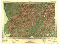
1951 Map of Goodnews
USGS Topo · Published 1953About this map
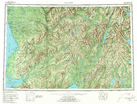
The Kanektok River and Togiak River systems dominate this coastal landscape, carving through the Kilbuck Mountains and Ahklun Mountains toward the Bering Sea. In the early 1950s, this region remained largely defined by seasonal movement and indigenous settlements, with Quinhagak established on Kuskokwim Bay and Togiak Village situated on the eastern shores of Togiak Bay. A notable cultural shift is visible near the mouth of the Togiak, where a site is marked as Togiak (Aban'd), suggesting a relocation of the community or a change in settlement patterns common to the era.
Find a feature on this map
73 named features on this map. Tap any name to fly to it.
Don’t see what you’re looking for? This feature index may not catch every label — zoom into the map to look around manually.
Map Details
Editions of this 1951 Goodnews Map
6 editions found

Other maps of this area

1945 · Nushagak Bay
USGS Topo · 1:250,000

1947 · Hagemeister Island D-2
USGS Topo · 1:63,360

1948 · Hagemeister Island D-3
USGS Topo · 1:63,360

1948 · Nushagak Bay D-4
USGS Topo · 1:63,360

1948 · Nushagak Bay D-3
USGS Topo · 1:63,360

1949 · Nushagak Bay
USGS Topo · 1:250,000

1950 · Bethel
USGS Topo · 1:250,000

1950 · Nushagak Bay D-5
USGS Topo · 1:63,360

1950 · Nushagak Bay D-6
USGS Topo · 1:63,360

1950 · Hagemeister Island D-6
USGS Topo · 1:63,360