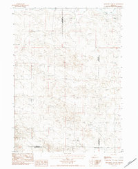
1983 Map of Kilpatrick Lake SW
USGS Topo · Published 1984About this map
The High Plains landscape of Sioux County meets the borders of Box Butte and Scotts Bluff counties in this early 1980s topographic study. The area is characterized by a sparse settlement pattern of established family holdings, including the R Henderson Ranch, J Henderson Ranch, and Nerud Ranch. These ranching operations are situated near vital water sources such as Mud Springs Creek and the South Branch Snake Creek in the northeast.
Find a feature on this map
13 named features on this map. Tap any name to fly to it.
Don’t see what you’re looking for? This feature index may not catch every label — zoom into the map to look around manually.
Map Details
Editions of this 1983 Kilpatrick Lake SW Map
This is the sole edition of this map. No revisions or reprints were ever made.
Other maps of this area

1898 · Scotts Bluff
USGS Topo · 1:125,000

1898 · Camp Clarke
USGS Topo · 1:125,000

1899 · Whistle Creek
USGS Topo · 1:125,000

1951 · Kilpatrick Lake
USGS Topo · 1:62,500

1954 · Scottsbluff
USGS Topo · 1:250,000

1955 · Alliance
USGS Topo · 1:250,000

1957 · Alliance
USGS Topo · 1:250,000

1958 · Alliance
USGS Topo · 1:250,000

1958 · Scottsbluff
USGS Topo · 1:250,000
1965 · Bayard NE
USGS Topo · 1:24,000