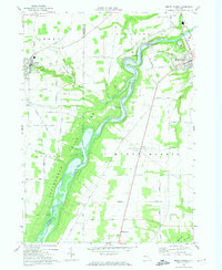
1972 Map of Mount Morris
USGS Topo · Published 1974About this map
Letchworth State Park dominates the western portion of this Livingston County landscape, where the Genesee River carves a deep path through the terrain. The engineering of the Mount Morris Dam is documented here in detail, including its Gaging Sta, Powerplant, and the Spillway Elev 760. This area serves as a critical infrastructure hub, featuring the Mt Morris Hospital and a Substation situated near the river's bend.
Find a feature on this map
62 named features on this map. Tap any name to fly to it.
Don’t see what you’re looking for? This feature index may not catch every label — zoom into the map to look around manually.
Map Details
Editions of this 1972 Mount Morris Map
2 editions found
Other maps of this area

1904 · Batavia
USGS Topo · 1:62,500

1904 · Caledonia
USGS Topo · 1:62,500

1905 · Portage
USGS Topo · 1:62,500

1905 · Nunda
USGS Topo · 1:62,500

1943 · Mount Morris
USGS Topo · 1:24,000

1943 · Sonyea
USGS Topo · 1:24,000

1943 · Nunda
USGS Topo · 1:24,000

1943 · Ossian
USGS Topo · 1:24,000

1943 · Castile
USGS Topo · 1:24,000

1943 · Portageville
USGS Topo · 1:24,000