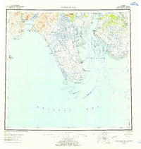
1951 Map of Nushagak Bay
USGS Topo · Published 1958About this map
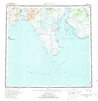
The Nushagak Peninsula terminates at Cape Constantine, a prominent geographical marker in this 1950s survey of the Bristol Bay region. This coastal landscape is defined by the shifting waters of Nushagak Bay, where several deep-water channels like Ship Channel and Schooner Channel navigate through extensive tidal flats and shoals. The human geography of the era is captured in the scattered settlements and industrial sites that relied on these waters, including Clarks Point and Ekuk.
Find a feature on this map
53 named features on this map. Tap any name to fly to it.
Don’t see what you’re looking for? This feature index may not catch every label — zoom into the map to look around manually.
Map Details
Editions of this 1951 Nushagak Bay Map
7 editions found

Other maps of this area

1943 · Ugashik
USGS Topo · 1:250,000

1945 · Nushagak Bay
USGS Topo · 1:250,000

1948 · Ugashik
USGS Topo · 1:250,000

1948 · Nushagak Bay D-4
USGS Topo · 1:63,360

1948 · Nushagak Bay D-3
USGS Topo · 1:63,360

1948 · Nushagak Bay C-4 And C-5
USGS Topo · 1:63,360

1948 · Hagemeister Island C-1
USGS Topo · 1:63,360

1949 · Ugashik
USGS Topo · 1:250,000

1949 · Nushagak Bay
USGS Topo · 1:250,000

1950 · Nushagak Bay B-4
USGS Topo · 1:63,360