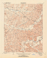
1900-1909 Maps of Kentucky
Explore 36 historic maps of Kentucky from 1900-1909. These maps offer a rare glimpse into what life looked like during the 1900s — showing old roads, neighborhoods, homes, and landmarks that have changed or disappeared over time.
Whether you're researching your family's past, planning a metal detecting trip, or studying how Kentucky's landscape evolved across the 1900s, these high-resolution maps are a powerful tool for exploring the history of this region.
- Focus on a specific era: All maps on this page are from the 1900s, giving you a focused view of this time period.
- See what’s changed: Compare century-old streets, trails, and buildings to today's modern landscape using overlays and satellite layers.
- Research with precision: Use these maps for genealogy, historical research, land use analysis, or educational projects.
- View, download, or print: Maps are fully viewable online in high resolution, and can be downloaded or printed for your own records.
Start exploring Kentucky's history through authentic maps from the 1900s. This is your window into the past.
Kentucky maps
(36)- 1900 Map of Ironton, 1918 Print
 1900 Ironton1918 Print · USGSThe Ohio River valley and the iron-rich hills of Lawrence County are seen here at the turn of the century during a peak in industrial activity. Genealogists and historians can trace defunct post offices like Orr P.O. and explore the rail corridors of the Ironton R.R. and Cincinnati Hamilton & Dayton R.R.2 unique versions available
 - 1901 Map of Owensboro
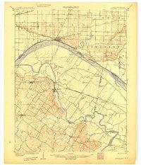
 1901 Owensboro1901 Print · USGSThe Ohio River bend at the turn of the century shows a bustling corridor of rail and river commerce between Kentucky and Indiana. Trace the early footprints of Owensboro and Rockport alongside vanished landmarks like Lake Mills and the Willow Pond Bed.5 unique versions available
 - 1901 Map of Ceredo, 1953 Print
 1901 Ceredo1953 Print · USGSThe tri-state convergence of West Virginia, Ohio, and Kentucky comes alive in this early 20th-century survey of the Ohio River valley. Genealogists and rail historians can trace the vital transport networks of Kenova and Ceredo, alongside family-named landmarks like Walker Br and Rice Run.2 unique versions available
 - 1903 Map of Kenova
 1903 Kenova1903 Print · USGSThe tri-state river junction at Ashland and Kenova was a bustling industrial hub after the turn of the century. Trace early rail lines and mining settlements like Coalton and Boghead, or locate family landmarks along the Little Sandy River and Means Tunnel.5 unique versions available
 - 1903 Map of Harlan
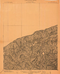 1903 Harlan1903 Print · USGSThe Harlan highlands are captured at the start of the twentieth century, showing the mountain landscape before industrial mining changed the region. Genealogists can trace early homesteads and drainage ways in the valleys near Harlan, Gray, and Puckett Creek.
 - 1903 Map of Pineville
 1903 Pineville1903 Print · USGSThe Cumberland Gap region in the early 1900s was a landscape defined by its formidable ridges and vital river passages. Trace the steep ascent of Cumberland Mountain and the winding course of the Cumberland River as they appeared over a century ago.
 - 1903 Map of Tell City
 1903 Tell City1903 Print · USGSThe Ohio River valley at the turn of the century is captured here as a vital corridor for both river and rail trade. Researchers can trace the early layouts of Tell City and Hawesville or locate smaller settlements like Knottsville and Waitman.7 unique versions available
 - 1903 Map of Middlesboro
 1903 Middlesboro1903 Print · USGSMiddlesboro sits at the gateway to the mountains in this early century survey of the Kentucky, Tennessee, and Virginia borders. Researchers can trace early migration routes and mountain passes like the famous Cumberland Gap, Baptist Gap, and Yellow Slip Gap.
 - 1904 Map of Kenova
 1904 Kenova1904 Print · USGSThe tri-state confluence of the Ohio River and Big Sandy River hums with early industrial activity at the start of the century. Genealogists can trace rail-side settlements and remote homesteads along Blaine Creek and near Mt Savage or Webbville.
 - 1905 Map of Harrodsburg
 1905 Harrodsburg1905 Print · USGSCentral Kentucky's Bluegrass region is captured here in the early twentieth century, showing a landscape defined by the deep gorges of the Kentucky River. Researchers can trace the era's vital rail networks and river commerce through features like Lock No 7 and the Louisville and Nashville RR.3 unique versions available
 - 1905 Map of Newburg
 1905 Newburg1905 Print · USGSThe Ohio River bottomlands of Indiana and Kentucky are captured here in the early twentieth century, showing a world defined by river transit and rail. Genealogists can locate river-town homesteads near Newburg or trace family river crossings at MASON FERRY and HAMILTON FERRY.3 unique versions available
 - 1905 Map of Prospect, 1962 Print
 1905 Prospect1962 Print · USGSThe Ohio River corridor north of Louisville comes alive in the early 1900s, showing a landscape of river landings and new electric railways. Researchers can find old landmarks like the Lakeland Asylum, the Kentucky Military Institute, and the Antioch Church.
 - 1905 Map of New Haven, 1966 Print
 1905 New Haven1966 Print · USGSThe tri-state border region along the Wabash and Ohio Rivers is captured here during the early twentieth century. Genealogists can trace family footprints in New Haven, Ridgway, and Herald, or locate historic crossings like Mackeys Ferry and Dogtown Ferry.
 - 1906 Map of New Haven
 1906 New Haven1906 Print · USGSThe Wabash River borderlands of Illinois and Indiana come to life in this early century survey of the river's winding oxbows and swampy bottoms. Genealogists can trace early homesteads near New Haven, Concord Emma P O, and the river landings at Dogtown Ferry.4 unique versions available
 - 1906 Map of Sebree
 1906 Sebree1906 Print · USGSWestern Kentucky at the dawn of the twentieth century was a landscape of rail-connected towns and crossroads hamlets. Genealogists can trace family footprints near Sebree and Dixon, or locate vanished schoolhouses and churches like Oakland Schoolhouse and Mt Pleasant Church.3 unique versions available
 - 1906 Map of Lockport
 1906 Lockport1906 Print · USGSOwen and Franklin Counties are surveyed here during the first decade of the century, following the dramatic bends of the Kentucky River. Researchers can trace the river-based economy through Lock & Dam No 1 and old crossings like Manfords Ferry.2 unique versions available
 - 1906 Map of Sutherland
 1906 Sutherland1906 Print · USGSDaviess and McLean counties come into focus at the start of the twentieth century, when the rail lines and river forks dictated the pace of rural life. Genealogists and local historians can trace early homes and landmarks near Utica, St Martins Church, and the distinctive Backbone Ridge.3 unique versions available
 - 1906 Map of Georgetown, 1954 Print
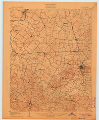
 1906 Georgetown1954 Print · USGSCentral Kentucky at the opening of the twentieth century was a landscape shaped by winding creeks and a dense web of steam rail lines. Local researchers can trace the historic rail corridors of the Southern R R and find early settlements like Paynes Depot and Great Crossing.
 - 1907 Map of Louisville
 1907 Louisville1907 Print · USGSLouisville and the rolling hills of Jefferson and Bullitt counties are captured here in the early 1900s. Researchers can trace ancestral connections through sites like Cave Hill Cemetery, Pleasant Grove Schoolhouse, and the river crossing at Bells Mill Ford.3 unique versions available
 - 1907 Map of Earlington
 1907 Earlington1907 Print · USGSWestern Kentucky coal and farm country comes alive in the early 1900s, centered on the growing hubs of Madisonville and Earlington. Genealogists and historians can trace dozens of rural schools and churches like Ramsey School, Nebo, and Mt Carmel Church.
 - 1907 Map of Morganfield
 1907 Morganfield1907 Print · USGSUnion County during the first decade of the twentieth century shows a landscape transitioning between its agrarian roots and a growing rail economy. Genealogists can locate family landmarks like Waggoner Church, the remote Topeka Crossroads, and the settlement at Seven Gums.3 unique versions available
 - 1907 Map of Whitesville, 1962 Print
 1907 Whitesville1962 Print · USGSDaviess and Ohio counties are captured here in the early 1900s, showcasing a rural landscape of crossroads settlements and river fords. Genealogists can locate specific family-named landmarks and community hubs like Hewlett's Store, Tanglewood School, and Little Zion Church.
 - 1908 Map of Lockport
 1908 Lockport1908 Print · USGSLife along the Kentucky River in the early twentieth century centered on the water and the rich flats of the river bottoms. Genealogists can trace family footprints through numerous river crossings like Harpers Ferry and rural landmarks such as Tackitts Mill or the Falling Rock School.3 unique versions available
 - 1908 Map of Calhoun
 1908 Calhoun1908 Print · USGSWestern Kentucky's river-driven economy is on full display in the first decade of the twentieth century, centered on the winding Green River. Researchers can trace ancestral locations in Beechgrove, Ashbyburg, and Calhoun, or locate vanished river crossings like Steamboat Ferry.2 unique versions available
 - 1908 Map of Georgetown
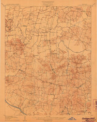
 1908 Georgetown1908 Print · USGSCentral Kentucky at the turn of the century reveals a landscape of thriving rail depots and historic turnpikes connecting major county seats. Genealogists and historians can trace the early footprints of Midway, Donerail, and Great Crossing along the winding North Elkhorn Creek.2 unique versions available
Showing maps 1-25 of 36
Top cities of Kentucky
- Louisville historical maps
- Lexington historical maps
- Owensboro historical maps
- Bowling Green historical maps
- Covington historical maps
- Georgetown historical maps
See more
Top counties of Kentucky
- Jefferson County historical maps
- Fayette County historical maps
- Kenton County historical maps
- Boone County historical maps
- Warren County historical maps
- Hardin County historical maps
See more
Frequently asked questions
- What are the different types of historical maps available for Kentucky?
- What is the oldest map of Kentucky?
- Where can I purchase historical maps of Kentucky for my home or office?
- Where can I download high-res historical maps of Kentucky?
- Are there historical topographic maps available for Kentucky?
- Is there historical aerial imagery available for Kentucky?
- Where are historical maps of Kentucky sourced from?