1920s Maps of Mississippi
Explore 26 historic maps of Mississippi from the 1920s. These maps offer a rare glimpse into what life looked like during the 1920s — showing old roads, neighborhoods, homes, and landmarks that have changed or disappeared over time.
Whether you're researching your family's past, planning a metal detecting trip, or studying how Mississippi's landscape evolved across the 1920s, these high-resolution maps are a powerful tool for exploring the history of this region.
- Focus on a specific era: All maps on this page are from the 1920s, giving you a focused view of this time period.
- See what’s changed: Compare century-old streets, trails, and buildings to today's modern landscape using overlays and satellite layers.
- Research with precision: Use these maps for genealogy, historical research, land use analysis, or educational projects.
- View, download, or print: Maps are fully viewable online in high resolution, and can be downloaded or printed for your own records.
Start exploring Mississippi's history through authentic maps from the 1920s. This is your window into the past.
Mississippi maps
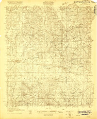
- 1921 Map of Natchez
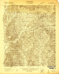
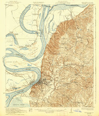
 1921 Natchez1921 Print · USGSThe Mississippi River bluffs and floodplain come alive in this early 1920s survey of the Natchez region and its Louisiana neighbors. Genealogists can trace family roots through numerous sites like Taconey Plantation, the Adams County Poor Farm, and Quitman School.
 - 1921 Map of Forest
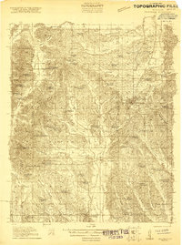
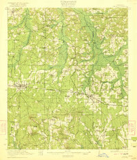
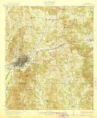
 1921 Forest1921 Print · USGSThe Scott County landscape in the early 1920s is documented here through its rural schoolhouses and family settlements. Genealogists can locate long-standing community centers like the Patrons Union Camp Ground, Singleton Settlement, and Fikestown.
 - 1921 Map of Grand Bay
 1921 Grand Bay1921 Print · USGSThe Mississippi and Alabama borderlands meet at the Gulf Coast during the early twentieth century, showing a landscape of tidal marshes and emerging rail towns. Genealogists and historians can trace the early footprints of Pecan, Orange Grove, and the shoreline Oyster factory.
 - 1921 Map of Booneville
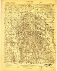
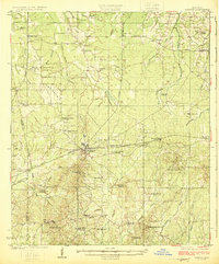
 1921 Booneville1921 Print · USGSNortheast Mississippi was a landscape of tightly-knit rural communities in the early 1920s. Researchers can trace dozens of family-named schools and churches like Bynum School, Gaston Church, and Jumpertown along the Mobile and Ohio RR.2 unique versions available
 - 1921 Map of Petit Bois Island
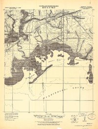
 1921 Petit Bois Island1921 Print · USGSThe barrier landscapes of the Gulf Coast appear in sharp detail during the early twentieth century. Researchers can trace the Alabama Mississippi Boundary Line across Petit Bois Island and locate the U.S. Gov't Reservation.
 - 1921 Map of Tupelo
 1921 Tupelo1921 Print · USGSNortheast Mississippi in the early twenties centers on the rail hub at Tupelo as it begins to connect with the fledgling Bankhead Highway system. Genealogists and local historians can trace rural family life through numerous landmarks like Campbelltown Cemetery, Clayton Store, and the Pratts School.2 unique versions available
 - 1921 Map of Meridian
 1921 Meridian1921 Print · USGSMeridian and Lauderdale County thrive as a major railroad hub in the early twenties. Researchers can trace family sites and community landmarks like Magnolia White Place, Knox Mill, and Cokers Chapel.4 unique versions available
 - 1921 Map of Nicholson
 1921 Nicholson1921 Print · USGSThe borderlands of Mississippi and Louisiana are captured here in the early 1920s, showing a river-driven landscape of timber and rail. Researchers can trace the riverfront communities of Gainsville and Logtown alongside the historic 3 Notch Road.
 - 1922 Map of Forest
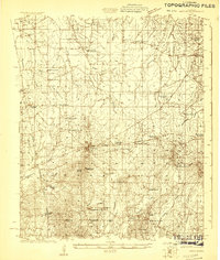
 1922 Forest1922 Print · USGSScott and Newton Counties are shown here in the early twenties, when timber and rails defined the landscape. You can trace the path of the Alabama and Vicksburg RR, locate family landmarks like Many Roads Hill, and find old meeting grounds like the Patrons Union Campground.2 unique versions available
 - 1922 Map of Morton
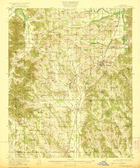
 1922 Morton1922 Print · USGSScott County in the early twenties is a landscape of rural schoolhouses and timber operations centered on the Morton rail line. Researchers can locate vanished community landmarks like the Scott County Fair Grounds, Lumber Camp, and several family-named churches.
 - 1922 Map of Pelahatchee
 1922 Pelahatchee1922 Print · USGSRankin County during the early 1920s reveals a landscape of dispersed agricultural communities and transit corridors. You can trace the roots of local settlements at Sand Hill and Leesburg, or locate family landmarks like Pisgah School and St Helen Church.
 - 1922 Map of Booneville
 1922 Booneville1922 Print · USGSPrentiss County during the early 1920s is centered on the Mobile and Ohio RR line connecting Booneville and Baldwyn. Family historians can trace local landmarks like Crossroads Church, Jumper School, and Blackland across this detailed rural landscape.
 - 1922 Map of Natchez, 1938 Print
 1922 Natchez1938 Print · USGSThe Mississippi River's shifting path at Natchez in the early twentieth century reveals a landscape of working plantations and thriving river ports. Researchers can trace land holdings at Windemere, locate rural sites like the Poor Farm, or follow the Yazoo and Mississippi Valley rail line.2 unique versions available
 - 1923 Map of Meridian
 1923 Meridian1923 Print · USGSMeridian emerged as a critical Mississippi rail junction in the early 1920s, anchoring a network of lines that fueled the local economy. Researchers can trace dozens of country landmarks, from Old Marion Cemetery to rural hubs like Garretts Store and Vimville.2 unique versions available
 - 1923 Map of Tupelo
 1923 Tupelo1923 Print · USGSLee County in the early twenties is a landscape of rural schoolhouses and rail junctions centered on the growing hub of Tupelo. Researchers can trace old family footprints at Campbelltown Cemetery or locate vanished sites like Kirks Gin and Beech Springs School.2 unique versions available
 - 1924 Map of Pelahatchee
 1924 Pelahatchee1924 Print · USGSRankin County in the 1920s is a landscape of rural schoolhouses and family-named prairies centered on the vital Alabama and Vicksburg RR. Researchers can trace the heritage of local communities through landmarks like the Brandon depot, Trickum Bridge, and Goshen Springs.
 - 1924 Map of Morton
 1924 Morton1924 Print · USGSThe rail-and-timber landscape of Scott and Rankin counties is captured here in the early twenties. Researchers can trace rural life through dozens of named landmarks like Peagler Store, Morton, and the Sprous Cemetery.
End of results
Showing maps 1-17
Top cities of Mississippi
- Jackson historical maps
- Gulfport historical maps
- Biloxi historical maps
- Hattiesburg historical maps
- Southaven historical maps
- Meridian historical maps
See more
Top counties of Mississippi
- Hinds County historical maps
- Harrison County historical maps
- DeSoto County historical maps
- Rankin County historical maps
- Jackson County historical maps
- Madison County historical maps
See more
Frequently asked questions
- What are the different types of historical maps available for Mississippi?
- What is the oldest map of Mississippi?
- Where can I purchase historical maps of Mississippi for my home or office?
- Where can I download high-res historical maps of Mississippi?
- Are there historical topographic maps available for Mississippi?
- Is there historical aerial imagery available for Mississippi?
- Where are historical maps of Mississippi sourced from?