1940s Maps of Mississippi
Explore 65 historic maps of Mississippi from the 1940s. These maps offer a rare glimpse into what life looked like during the 1940s — showing old roads, neighborhoods, homes, and landmarks that have changed or disappeared over time.
Whether you're researching your family's past, planning a metal detecting trip, or studying how Mississippi's landscape evolved across the 1940s, these high-resolution maps are a powerful tool for exploring the history of this region.
- Focus on a specific era: All maps on this page are from the 1940s, giving you a focused view of this time period.
- See what’s changed: Compare century-old streets, trails, and buildings to today's modern landscape using overlays and satellite layers.
- Research with precision: Use these maps for genealogy, historical research, land use analysis, or educational projects.
- View, download, or print: Maps are fully viewable online in high resolution, and can be downloaded or printed for your own records.
Start exploring Mississippi's history through authentic maps from the 1940s. This is your window into the past.
Mississippi maps
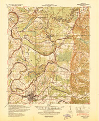
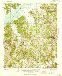
(65)- 1940 Map of Spring Creek
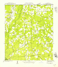 1940 Spring Creek1940 Print · USGSTangipahoa Parish at the start of the 1940s is a landscape of creek-side farms and rural crossroads. Trace family roots and local landmarks like German Cem, Midway Sch, and the Illinois Central Railroad corridor.
 - 1940 Map of Seven Pines
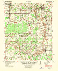
 1940 Seven Pines1940 Print · USGSThe Yazoo River Delta and Carroll County hills meet in the 1940s, showing a landscape of river-bend towns and rural schools. Genealogists can locate family landmarks like Matthews Cem, Smith Chapel, and the riverside rail stop at Sidon.
 - 1940 Map of Auter, 1941 Print
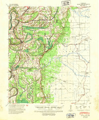
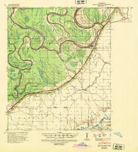
 1940 Auter1941 Print · USGSThe Mississippi Delta in the early 1940s is captured here as a world of river landings and plantation agriculture along the Big Sunflower River. Genealogists and researchers can trace family landmarks at Hard Cash, Midnight, and Daybreak Plantation.
 - 1940 Map of Baird, 1942 Print
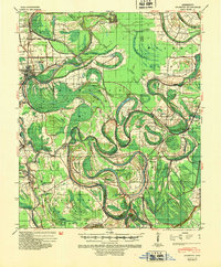
 1940 Baird1942 Print · USGSThe Mississippi Delta's intricate river and rail economy is on full display during the early 1940s. Genealogists and historians can trace family roots through specific landmarks like Price School, Heard Ferry, and the many small settlements like Baird and Inverness.
 - 1940 Map of Lexington, 1945 Print
 1940 Lexington1945 Print · USGSHolmes County at the start of the 1940s is captured here as a landscape of rail-connected towns and rural parish communities. Researchers can trace family roots through landmarks like the County Poor House, Industrial Sch, and Mt Sinai Ch.
 - 1940 Map of Greenwood, 1945 Print
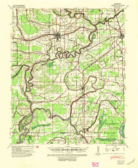
 1940 Greenwood1945 Print · USGSThe Mississippi Delta's river-and-rail economy is in full view at the start of the 1940s, where the Yazoo River begins. Genealogists and historians can trace rural communities through the Rosenwald Sch, Ruby Sta, and the historic Malmaison estate.
 - 1940 Map of Cleveland, 1946 Print
 1940 Cleveland1946 Print · USGSBolivar and Sunflower counties are seen here in the early 1940s, as the delta landscape was being transformed by major flood control projects. Genealogists can trace family roots through numerous local landmarks like Boyer Cem, Hannahs Bridge, and the Doddsville Industrial Institute.
 - 1940 Map of Mechanicsburg, 1947 Print
 1940 Mechanicsburg1947 Print · USGSThe Yazoo River Delta in the early 1940s reveals a landscape defined by steamboat landings and the edge of the Loess Bluffs. Researchers can trace historic river access points like Enola Ldg and Miller Ldg or locate the early footprints of Satartia and Mechanicsburg.2 unique versions available
 - 1940 Map of Mileston, 1953 Print
 1940 Mileston1953 Print · USGSThe Mississippi Delta's winding waterways and rail-linked settlements are captured here just before the mid-century. Genealogists can trace family roots through communities like Mileston and Silver City, or locate specific landmarks like the Good Hope Ch and ancient Indian Mounds.
 - 1940 Map of Oxford, 1956 Print
 1940 Oxford1956 Print · USGSLafayette County was undergoing a major landscape shift in the 1940s as the Sardis Reservoir took shape northwest of Oxford. Researchers can trace the early layout of the University of Mississippi and dozens of rural landmarks like Pearly Gate Ch and College Hill Sta.2 unique versions available
 - 1941 Map of Honey Island
 1941 Honey Island1941 Print · USGSThe lower Pearl River basin at the start of the 1940s reveals a dense network of swamp bayous and rail sidings. Genealogists and historians can trace the paths of Highway No 11 and the Southern railroad through Benton and past Honey Island.
 - 1941 Map of Woodland
 1941 Woodland1941 Print · USGSEast Feliciana Parish and the Mississippi borderlands are captured here in the early 1940s. Researchers can trace rural life through landmarks like Felixville P. O., family sites like Kent Cem, and schools such as Phares Sch and Macedonia Sch.
 - 1941 Map of Norwood
 1941 Norwood1941 Print · USGSEast Feliciana Parish near the Mississippi border reveals its 1940s landscape of rural settlements and transport corridors. Genealogists can trace family roots through landmarks like Antioch Ch, Morning Glory Ch, and burial sites such as Beech Grove Cem.
 - 1941 Map of Lost Creek
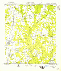
 1941 Lost Creek1941 Print · USGSThe borderlands of East and West Feliciana Parish come alive in this early 1940s survey of rural Louisiana. Genealogists can trace family landmarks like Rogillioville, Hickory Grove Sch, and the Mc Queen Cem alongside the Illinois Central rail line.
 - 1941 Map of Chipola
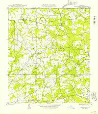
 1941 Chipola1941 Print · USGSSt. Helena and East Feliciana parishes are shown here in the early 1940s just as the modern highway system began to solidify. Family historians can trace local roots at Hurst Cem, Joiners, and rural school sites like St Helena Sch.
 - 1941 Map of Batchelor, 1944 Print
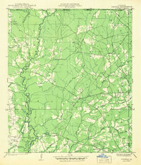
 1941 Batchelor1944 Print · USGSThe Mississippi River's powerful shifts define this corner of Louisiana in the early 1940s, from the oxbows of the Raccourci Old River to the banks of Angola. Local researchers can locate family landmarks such as Mains Plantation, St Stevens Ch, and the Lower Latanache Sch.
 - 1941 Map of Vicksburg, 1946 Print
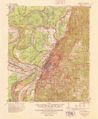 1941 Vicksburg1946 Print · USGSVicksburg and its riverfront were entering the war years when this survey was updated, documenting a landscape of strategic waterway engineering. Genealogists can trace family roots at Redwood, Beechwood, or Culkin Academy and locate the National Cem.3 unique versions available
 - 1941 Map of Hurley, 1953 Print
 1941 Hurley1953 Print · USGSThe borderlands between Mississippi and Alabama are captured here in the early 1940s as rural life centered on the river and rail. Local researchers can trace family landmarks and forgotten road networks from Hurley to St Elmo, including Tanners Cem, Baker Sch, and Slaughter Flat Landing.3 unique versions available
 - 1941 Map of Vancleave, 1959 Print
 1941 Vancleave1959 Print · USGSThe Pascagoula River bottomlands in the early 1940s reveal a landscape of oxbow lakes and timber-reliant settlements. Trace family roots at Wolf Ridge Cem, Graham Ferry, or the historic crossroads of Vancleave and Old Americus.4 unique versions available
 - 1941 Map of Lucedale, 1961 Print
 1941 Lucedale1961 Print · USGSGeorge County's timber and rail landscape is meticulously captured here in the early 1940s as the rail lines intersect at Lucedale. Genealogists can trace family roots through numerous sites like Agricola High Sch, Woodard Cem, and the Mengel Lumber Camp.2 unique versions available
 - 1941 Map of Horn Island, 1964 Print
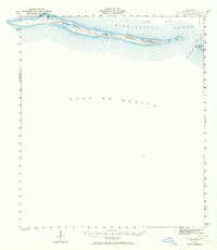 1941 Horn Island1964 Print · USGSThe barrier islands of Jackson County appear in their pre-war state during this early 1940s survey of the Gulf Coast. Marine researchers and local historians can trace the navigation routes through Horn Island Pass and the shifting Sand Dunes of Horn Island.
 - 1942 Map of Petit Bois Island
 1942 Petit Bois Island1942 Print · USGSCoastal barrier islands along the Alabama and Mississippi border appear in this wartime survey, showing the shifting sands before modern development. Maritime researchers can trace the navigational landscape of Petit Bois Pass and the position of the Horn Island L H.
 - 1942 Map of Raymond
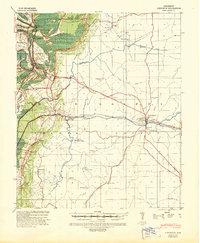
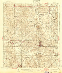 1942 Raymond1942 Print · USGSHinds County in the early 1940s served as a regional crossroads of education and rail transport during a period of steady rural development. Researchers can locate family landmarks such as New Salem Cem, trace the Illinois Central tracks, and find long-standing institutions like Mississippi College.
 - 1942 Map of Liverpool
 1942 Liverpool1942 Print · USGSSt. Helena Parish at the start of the 1940s is a landscape of rural homesteads and river branches along the Mississippi border. Researchers can trace family sites like Anglin Cem and Bates Cem or locate the old Oakland Sch and the Liverpool Fire Tower.
 - 1942 Map of Horn Island
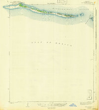 1942 Horn Island1942 Print · USGSThe barrier islands of the Mississippi coast are documented in detail here during the early forties. Researchers can trace the shifting shoreline of Horn Island and examine the coastal geography of Petit Bois Island and Horn Island Pass.
Showing maps 1-25 of 65
Top cities of Mississippi
- Jackson historical maps
- Gulfport historical maps
- Biloxi historical maps
- Hattiesburg historical maps
- Southaven historical maps
- Meridian historical maps
See more
Top counties of Mississippi
- Hinds County historical maps
- Harrison County historical maps
- DeSoto County historical maps
- Rankin County historical maps
- Jackson County historical maps
- Madison County historical maps
See more
Frequently asked questions
- What are the different types of historical maps available for Mississippi?
- What is the oldest map of Mississippi?
- Where can I purchase historical maps of Mississippi for my home or office?
- Where can I download high-res historical maps of Mississippi?
- Are there historical topographic maps available for Mississippi?
- Is there historical aerial imagery available for Mississippi?
- Where are historical maps of Mississippi sourced from?