1920s Maps of Wyoming
Explore 7 historic maps of Wyoming from the 1920s. These maps offer a rare glimpse into what life looked like during the 1920s — showing old roads, neighborhoods, homes, and landmarks that have changed or disappeared over time.
Whether you're researching your family's past, planning a metal detecting trip, or studying how Wyoming's landscape evolved across the 1920s, these high-resolution maps are a powerful tool for exploring the history of this region.
- Focus on a specific era: All maps on this page are from the 1920s, giving you a focused view of this time period.
- See what’s changed: Compare century-old streets, trails, and buildings to today's modern landscape using overlays and satellite layers.
- Research with precision: Use these maps for genealogy, historical research, land use analysis, or educational projects.
- View, download, or print: Maps are fully viewable online in high resolution, and can be downloaded or printed for your own records.
Start exploring Wyoming's history through authentic maps from the 1920s. This is your window into the past.
Wyoming maps
- 1920 Map of Home
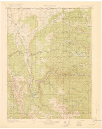 1920 Home1920 Print · USGSLarimer County at the end of the Great War was a landscape of high-country ranches and forest outposts. Genealogists and historians can locate family homesteads like Derby Ranch and Bennett Ranch or trace the early operations of the Black Mtn School and Manhattan.4 unique versions available
 - 1921 Map of Saddleback Hills
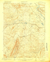 1921 Saddleback Hills1921 Print · USGSCarbon County at the start of the 1920s shows a landscape shaped by the Union Pacific Railroad and early transit routes. You can trace the historic footprint of Carbon or locate remote watering holes like Missouri John Spring and Fiddlers Green.2 unique versions available
 - 1921 Map of Afton
 1921 Afton1921 Print · USGSStar Valley and the high Wyoming backcountry are captured here in the early twenties, showing the region's early ranching and forestry roots. Researchers can locate early schools like Muddy String School, isolated outposts like Moffat Ranch, and forest service sites including Corral Creek Ranger Sta.
End of results
Showing maps 1-3
Top cities of Wyoming
- Cheyenne historical maps
- Casper historical maps
- Laramie historical maps
- Gillette historical maps
- Rock Springs historical maps
- Sheridan historical maps
See more
Top counties of Wyoming
- Laramie County historical maps
- Natrona County historical maps
- Campbell County historical maps
- Sweetwater County historical maps
- Fremont County historical maps
- Albany County historical maps
See more
Frequently asked questions
- What are the different types of historical maps available for Wyoming?
- What is the oldest map of Wyoming?
- Where can I purchase historical maps of Wyoming for my home or office?
- Where can I download high-res historical maps of Wyoming?
- Are there historical topographic maps available for Wyoming?
- Is there historical aerial imagery available for Wyoming?
- Where are historical maps of Wyoming sourced from?