1910s Maps of Wyoming
Explore 70 historic maps of Wyoming from the 1910s. These maps offer a rare glimpse into what life looked like during the 1910s — showing old roads, neighborhoods, homes, and landmarks that have changed or disappeared over time.
Whether you're researching your family's past, planning a metal detecting trip, or studying how Wyoming's landscape evolved across the 1910s, these high-resolution maps are a powerful tool for exploring the history of this region.
- Focus on a specific era: All maps on this page are from the 1910s, giving you a focused view of this time period.
- See what’s changed: Compare century-old streets, trails, and buildings to today's modern landscape using overlays and satellite layers.
- Research with precision: Use these maps for genealogy, historical research, land use analysis, or educational projects.
- View, download, or print: Maps are fully viewable online in high resolution, and can be downloaded or printed for your own records.
Start exploring Wyoming's history through authentic maps from the 1910s. This is your window into the past.
Wyoming maps
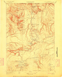
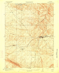
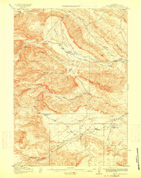
- 1910 Map of Rock Springs
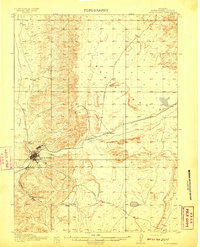 1910 Rock Springs1910 Print · USGSRock Springs and the surrounding high desert are captured here during a pivotal era of railroad expansion and mining growth. Researchers can trace the early layout of Rock Springs and Blairtown or locate smaller outposts like Gunn and Baxter along the Union Pacific line.3 unique versions available
 - 1910 Map of Eaton
 1910 Eaton1910 Print · USGSNorthern Colorado at the turn of the century shows a landscape transformed by railroads and early irrigation projects. Genealogists can locate many family-named landmarks like Slaxton Ranch and rural schoolhouses including Abbot School and Birch School.3 unique versions available
 - 1910 Map of Gros Ventre
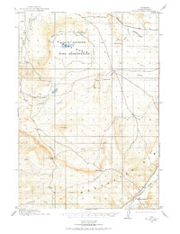
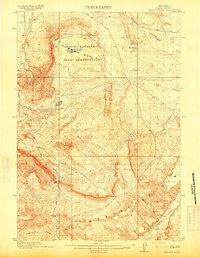
 1910 Gros Ventre1910 Print · USGSThe Gros Ventre Range is shown in the early twentieth century as a network of isolated family homesteads and early forest reserves. Genealogists and historians can trace pioneer roots at Bondurant, Twin Creek School, and Darwin Ranch.3 unique versions available
 - 1911 Map of Lake
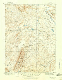
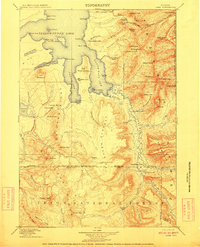 1911 Lake1911 Print · USGSYellowstone's southeastern wilderness is mapped here in the early twentieth century, showing the remote high plateaus and the intricate arms of the great lake. Researchers can trace the Continental Divide across Two Ocean Pass and locate isolated outposts like Snowshoe Cabin and Hawks Rest.2 unique versions available
 - 1911 Map of Shoshone
 1911 Shoshone1911 Print · USGSThe thermal basins and early back-country outposts of southern Yellowstone are captured here in the early nineteen-hundreds. Trace early tourism and patrol routes through the Shoshone Geyser Basin, the Thumb Hotel, and the Snowshoe Cabin.3 unique versions available
 - 1911 Map of Sheridan
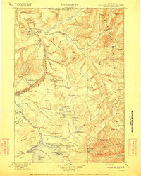
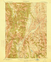
 1911 Sheridan1911 Print · USGSSheridan and the surrounding northern Wyoming ranchlands are captured here during a period of rapid railroad expansion. Researchers can trace the Chicago Burlington and Quincy RR through Dietz and Verona, or locate early homesteads like Wagoner Ranch.2 unique versions available
 - 1911 Map of Gallatin
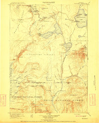
 1911 Gallatin1911 Print · USGSYellowstone's thermal wonders and early military outposts are recorded in detail just after the turn of the century. Researchers can trace the early road and trail systems connecting landmark sites like Fort Yellowstone, the Norris Geyser Basin, and the Fountain Hotel.2 unique versions available
 - 1911 Map of Canyon
 1911 Canyon1911 Print · USGSYellowstone National Park is captured here in the early twentieth century as a fledgling wilderness preserve. Researchers can trace the early road system including the Cooke Road and find historic sites like Yanceys, the Canyon Hotel, and Fishing Bridge.6 unique versions available
 - 1911 Map of Montpelier
 1911 Montpelier1911 Print · USGSThe Bear Lake Valley at the start of the twentieth century was a vital rail and ranching corridor. Trace the Oregon Short Line RR through Montpelier and Paris, or locate early lakeside settlements like Fish Haven and St Charles.3 unique versions available
 - 1911 Map of Meeteetse, 1957 Print
 1911 Meeteetse1957 Print · USGSMeeteetse and the Bighorn Basin are captured here in the early twentieth century as ranching and early mining took hold. Researchers can trace the historic Cody Road and locate old landmarks like the Black Diamond Mine and Renner's Ranch.
 - 1911 Map of Cheyenne, 1961 Print
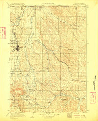
 1911 Cheyenne1961 Print · USGSCheyenne was a bustling rail and military center in the years before the Great War. Genealogists and historians can trace the footprint of Fort D.A. Russell and find early rural sites like Campstool and Paola.
 - 1911 Map of Oregon Basin, 1975 Print
 1911 Oregon Basin1975 Print · USGSThe high basin of Park County comes into focus just before the Great War, showing early ranching and mining efforts in the Wyoming desert. Genealogists can locate Sleeper's Ranch and Red Cabin, while historians can trace the Wiley Canal (Abandoned) and the early workings of the Wiley Mine.
 - 1912 Map of Randolph
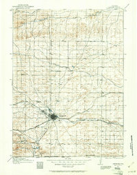
 1912 Randolph1912 Print · USGSThe high valley ranching country of the Utah-Wyoming border is captured here in the early twentieth century. Genealogists and historians can trace family land holdings such as Rex Ranch or Sixmile Ranch and find old routes like the Ogden Road.3 unique versions available
 - 1913 Map of Oregon Basin
 1913 Oregon Basin1913 Print · USGSPark County, Wyoming, appears here during a transformative era of early irrigation and mining development just before the First World War. Researchers can trace historic infrastructure like the Wiley Canal (Abandoned), the Eagle Mine, and the original Sleeper's Ranch.2 unique versions available
 - 1913 Map of Meeteetse
 1913 Meeteetse1913 Print · USGSMeeteetse and the surrounding ranchlands are captured here in the years before World War I. Researchers can trace the early road network like Cody Road or locate historical sites such as Dumbell, Sunshine, and the Black Diamond Mine.3 unique versions available
 - 1913 Map of Grass Creek Basin, 1962 Print
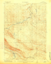
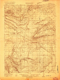
 1913 Grass Creek Basin1962 Print · USGSHot Springs County ranching life is preserved here during the early twentieth century, showing a remote landscape of isolated family homesteads and vital water sources. Genealogists and historians can locate early properties like Wales Ranch and Kemp Ranch, or trace the rugged geography of the Putney Mine and Grass Creek Basin.2 unique versions available
 - 1914 Map of Hanna
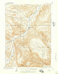
 1914 Hanna1914 Print · USGSCarbon County ranching and railroad life come into focus in the years before the Great War. You can trace the early irrigation networks and family outposts like Brooks Ranch and Kinney's Ranch or locate the original layouts of Hanna and Threetown.3 unique versions available
 - 1914 Map of Walcott
 1914 Walcott1914 Print · USGSCarbon County ranching and rail operations are in full swing in the years before the Great War. You can trace the Union Pacific line through Fort Steele and Walcott, or locate legacy homesteads like Ferris Ranch and Corson Ranch.2 unique versions available
 - 1914 Map of Cheyenne
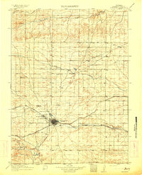 1914 Cheyenne1914 Print · USGSCheyenne stands at the crossroads of three major railroads in the years before the Great War. Researchers can trace the layout of the Fort D.A. Russell Military Reservation and find local landmarks like Ridley School and Campstool.3 unique versions available
 - 1914 Map of Saddleback Hills, 1958 Print
 1914 Saddleback Hills1958 Print · USGSCarbon County’s rail and ranching landscape is captured here before the First World War, centered on the historic high-plains corridor of the Union Pacific. Local historians can trace the early road network and vital water stops like Missouri John Spring, Como Lake, and the settlement at Carbon.
 - 1914 Map of Blue Mesa, 1975 Print
 1914 Blue Mesa1975 Print · USGSHot Springs and Washakie Counties are documented here shortly after the turn of the century, showing a remote landscape defined by its vital water sources. Researchers can trace the paths of Cottonwood Creek and Grass Creek, or locate Keg Spring and Harris Spring among the draws of Blue Mesa.
 - 1915 Map of Freedom
 1915 Freedom1915 Print · USGSThe Idaho-Wyoming border comes alive in this survey of the high mountain ranges and irrigated valleys during the early twentieth century. Researchers can trace the path of the Lander Cutoff and locate early community landmarks like the Freedom School or the Old Salt Works.3 unique versions available
 - 1915 Map of Grass Creek Basin
 1915 Grass Creek Basin1915 Print · USGSHot Springs County homesteads and early Wyoming resource extraction are documented here in the years before the Great War. Genealogists and historians can locate family-named landmarks like Littlejohn Ranch, Putney Mine, and Wagonhound Spring.3 unique versions available
 - 1915 Map of Crow Creek
 1915 Crow Creek1915 Print · USGSThe high-desert ranching and salt industries of the Idaho-Wyoming border are captured here just before World War I. Researchers can locate early family homesteads like Cozzens Ranch and Books Ranch, or trace the operations at the Old Salt Works.3 unique versions available
 - 1915 Map of Como Ridge
 1915 Como Ridge1915 Print · USGSThe high plains of Carbon County come alive in the early twentieth century as the legendary Lincoln Highway pushes westward alongside the Union Pacific. Genealogists and historians can trace the early development of Medicine Bow and locate rural landmarks like the Ambler School and Robbers Roost.2 unique versions available
Showing maps 1-25
Top cities of Wyoming
- Cheyenne historical maps
- Casper historical maps
- Laramie historical maps
- Gillette historical maps
- Rock Springs historical maps
- Sheridan historical maps
See more
Top counties of Wyoming
- Laramie County historical maps
- Natrona County historical maps
- Campbell County historical maps
- Sweetwater County historical maps
- Fremont County historical maps
- Albany County historical maps
See more
Frequently asked questions
- What are the different types of historical maps available for Wyoming?
- What is the oldest map of Wyoming?
- Where can I purchase historical maps of Wyoming for my home or office?
- Where can I download high-res historical maps of Wyoming?
- Are there historical topographic maps available for Wyoming?
- Is there historical aerial imagery available for Wyoming?
- Where are historical maps of Wyoming sourced from?