1900-1909 Maps of Wyoming
Explore 124 historic maps of Wyoming from 1900-1909. These maps offer a rare glimpse into what life looked like during the 1900s — showing old roads, neighborhoods, homes, and landmarks that have changed or disappeared over time.
Whether you're researching your family's past, planning a metal detecting trip, or studying how Wyoming's landscape evolved across the 1900s, these high-resolution maps are a powerful tool for exploring the history of this region.
- Focus on a specific era: All maps on this page are from the 1900s, giving you a focused view of this time period.
- See what’s changed: Compare century-old streets, trails, and buildings to today's modern landscape using overlays and satellite layers.
- Research with precision: Use these maps for genealogy, historical research, land use analysis, or educational projects.
- View, download, or print: Maps are fully viewable online in high resolution, and can be downloaded or printed for your own records.
Start exploring Wyoming's history through authentic maps from the 1900s. This is your window into the past.
Wyoming maps
- 1900 Map of Coalville, 1955 Print
 1900 Coalville1955 Print · USGSThe high valleys of Summit and Wasatch counties are captured at the turn of the century as the silver and coal industries flourished. Researchers can trace early settlements like Rockport and Hailstone or locate the industrial Ontario Drain Tunnel near Park City.2 unique versions available
 - 1900 Map of Fort McKinney, 1956 Print
 1900 Fort McKinney1956 Print · USGSJohnson County was a landscape of military outposts and early ranching during the 1890s. Researchers can trace the layout of the Fort Mc Kinney Military Reservation or locate family sites like the T A Ranch and Hepp Ranch.
 - 1901 Map of Rosebud
 1901 Rosebud1901 Print · USGSSouthern Montana ranching and rail life are documented here during the final decade of the nineteenth century. Genealogists and historians can trace early holdings like Yellow Weasel Ranch and Sand Hills Ranch along the Burlington and Missouri River R. R.4 unique versions available
 - 1901 Map of Canyon
 1901 Canyon1901 Print · USGSYellowstone's northeast wilderness appears at the dawn of the twentieth century, detailing the park's early infrastructure and raw geothermal wonders. Researchers can trace the original locations of Yanceys, Baronett Bridge, and unique curiosities like the Fossil Forest.
 - 1901 Map of Shoshone
 1901 Shoshone1901 Print · USGSYellowstone's geothermal wonders and early park boundaries are detailed here during the late Victorian era. Researchers can trace the early footprint of the Old Faithful Hotel and locate remote hydrothermal sites like Shoshone Geyser Basin and Rustic Geyser.
 - 1901 Map of Cloud Peak
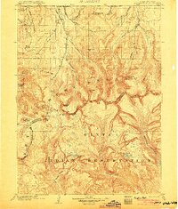
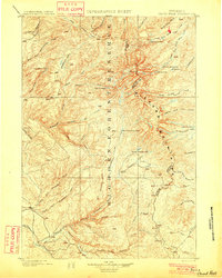 1901 Cloud Peak1901 Print · USGSThe high alpine country of the Big Horn range is captured here at the turn of the century just after its designation as a Forest Reserve. Researchers can trace the rugged headwaters of the Powder River and find remote landmarks like Lake Solitude, Black Butte, and Cloud Peak Lake.7 unique versions available
 - 1901 Map of Dayton
 1901 Dayton1901 Print · USGSSheridan County and the Montana borderlands are captured here at the turn of the century as the railroad reshapes the valley. Researchers can trace early settlements and ranching outposts like Slack, Beckton, and the Morrow Ranch along the Tongue River.5 unique versions available
 - 1901 Map of St. Xavier
 1901 St. Xavier1901 Print · USGSBig Horn County at the turn of the century shows a frontier landscape shaped by military history and the early years of the Crow Reservation. Researchers can trace the path of the Old Bozeman Military Road past the Site of Old Fort C. F. Smith and the St. Xavier Mission.4 unique versions available
 - 1901 Map of Gallatin
 1901 Gallatin1901 Print · USGSThe high plateau of the Yellowstone country appears here in the late nineteenth century, just as its hydrothermal wonders were becoming globally known. Researchers can locate early campsites and lodges near the Norris Geyser Basin, Obsidian Cliff, and Mammoth Hot Springs.
 - 1901 Map of Lake
 1901 Lake1901 Print · USGSYellowstone's wilderness at the dawn of the twentieth century is charted here through its complex alpine hydrography and high-altitude peaks. Researchers can trace early park boundaries and remote landmarks like Hawks Rest, Brimstone Basin, and Frank Island.
 - 1901 Map of Hartville
 1901 Hartville1901 Print · USGSEastern Wyoming at the turn of the century reveals a landscape defined by the arrival of the rails and the legacy of the frontier. Genealogists can trace family ranching sites like Dotys Ranch or early towns such as Hartville and Fort Laramie.2 unique versions available
 - 1901 Map of Hayden Peak
 1901 Hayden Peak1901 Print · USGSThe high Uintas at the turn of the century appear here as a pristine wilderness of alpine peaks and glacial lakes. Genealogists and researchers can trace the headwaters of the Bear River and Provo River or locate early landmarks like Holiday Park and Grandaddy Lake.2 unique versions available
 - 1901 Map of Newcastle
 1901 Newcastle1901 Print · USGSThe Wyoming-South Dakota borderlands come alive in this survey conducted just before the turn of the century, centered on the railroad hub of Newcastle. Genealogists and historians can trace early cattle history at Lak Ranch and the industrial spur leading to the coal-mining town of Cambria.3 unique versions available
 - 1901 Map of Bald Mountain
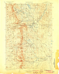
 1901 Bald Mountain1901 Print · USGSNorthern Wyoming's high peaks and timber reserves are captured here at the turn of the century. Researchers can trace early industrial sites like Fortunatus Mill and the isolated settlement of Cloverly near the Shell Creek drainage.4 unique versions available
 - 1901 Map of Grand Teton, 1909 Print
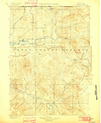
 1901 Grand Teton1909 Print · USGSThe Teton valley was a land of homesteads and river crossings at the turn of the century. Genealogists can trace early settler families at Grovont and numerous holdings like Cunningham Ranch or locate the historic Menor Ferry crossing.4 unique versions available
 - 1901 Map of Aladdin, 1954 Print
 1901 Aladdin1954 Print · USGSCrook County ranching and rail life at the turn of the century is preserved here, from the mountain slopes to the river valleys. Genealogists can trace early homesteads and shipping points like Aladdin, Beulah, and the VVV Ranch.
 - 1902 Map of Laramie
 1902 Laramie1902 Print · USGSThe high plains of Albany County come alive in this turn-of-the-century survey centered on the growing rail hub of Laramie. Genealogists and researchers can trace early homesteads and landmarks like Sartoris Ranch, Ft. Sanders, and the Union Pacific R. R. line.
 - 1902 Map of Sundance
 1902 Sundance1902 Print · USGSThe Wyoming and South Dakota borderlands come into focus at the turn of the century as ranching and early mining outposts take hold. Genealogists and historians can trace family-named sites like Mc Creadys Ranch and early settlements including Manhattan and Buckhorn.4 unique versions available
 - 1902 Map of Mt Leidy
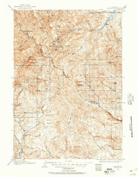
 1902 Mt Leidy1902 Print · USGSTeton and Uinta counties are shown here at the turn of the century as a wilderness of forest reserves and high mountain passes. Researchers can trace early routes over the Continental Divide at Twogwotee Pass or locate the remote Dick Turpin Meadow.5 unique versions available
 - 1903 Map of Hayden Peak
 1903 Hayden Peak1903 Print · USGSThe high Uintas at the beginning of the twentieth century reveal a landscape split between the Uinta Forest Reserve and the Uinta Indian Reservation. Researchers can trace the original Utah-Wyoming Boundary Line and the headwaters of the Bear River and Duchesne River.6 unique versions available
 - 1903 Map of Fort McKinney
 1903 Fort McKinney1903 Print · USGSJohnson County at the turn of the century shows a landscape transitioning from military frontier to a ranching economy. Researchers can locate early family outposts like Trabing, Greub, and the T A Ranch alongside the Fort Mc. Kinney Military Reservation.3 unique versions available
 - 1903 Map of Aladdin
 1903 Aladdin1903 Print · USGSThe northern Black Hills region at the turn of the century reveals a landscape defined by the arrival of the Wyoming and Missouri River R.R. and expansive cattle ranching. Researchers can trace the early footprints of settlements like Aladdin and Beulah, alongside established landmarks like the VVV Ranch and Schoolmarm Butte.3 unique versions available
 - 1903 Map of Coalville, 1921 Print
 1903 Coalville1921 Print · USGSUpper Utah at the turn of the century reveals a landscape defined by mining corridors and valley settlements. Genealogists and historians can trace the early path of the Union Pacific R. R. through Coalville or locate family-named sites like Rigby's Ranch and the Ontario Drain Tunnel.2 unique versions available
 - 1904 Map of Kirwin, 1957 Print
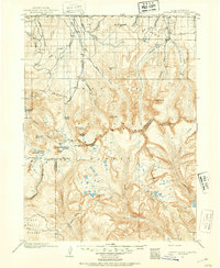
 1904 Kirwin1957 Print · USGSHigh-country mining and ranching define this region of the Absaroka Range at the turn of the century. Genealogists can trace family holdings like Double Diamond Ranch and Antler Ranch, or the high-altitude mining outpost at Kirwin.
 - 1905 Map of Devils Tower
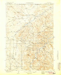 1905 Devils Tower1905 Print · USGSCrook County ranching and the northern Black Hills landscape are captured here in the early 1900s. Genealogists can trace early homesteading era holdings like Hulett Ranch and Yeasts Ranch near the landmark of Devils Tower.2 unique versions available
Showing maps 1-25
Top cities of Wyoming
- Cheyenne historical maps
- Casper historical maps
- Laramie historical maps
- Gillette historical maps
- Rock Springs historical maps
- Sheridan historical maps
See more
Top counties of Wyoming
- Laramie County historical maps
- Natrona County historical maps
- Campbell County historical maps
- Sweetwater County historical maps
- Fremont County historical maps
- Albany County historical maps
See more
Frequently asked questions
- What are the different types of historical maps available for Wyoming?
- What is the oldest map of Wyoming?
- Where can I purchase historical maps of Wyoming for my home or office?
- Where can I download high-res historical maps of Wyoming?
- Are there historical topographic maps available for Wyoming?
- Is there historical aerial imagery available for Wyoming?
- Where are historical maps of Wyoming sourced from?