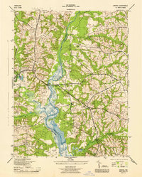
1944 Map of Bristol
USGS Topo · Published 1944About this map
The Patuxent River defines the landscape of this 1940s survey, serving as the boundary between Prince Georges and Anne Arundel counties. The wetlands and meandering channels of the river are flanked by several small agricultural and rural centers including Bristol, Leeland, and Greenock. The presence of the Chesapeake Beach RR and the Crain Highway indicates a region transitioning through early-20th-century transportation shifts. Genealogists will find a wealth of local landmarks, from the Adams Church and St Lukes Chapel to the Bristol Sch and Brookridge School. One notable site is the Abandoned Airport near the confluence with Lyons Creek, suggesting a brief moment of early aviation history in the area. The map also detail various districts such as Queen Anne District No 7 and District No 8.
Find a feature on this map
45 named features on this map. Tap any name to fly to it.
Don’t see what you’re looking for? This feature index may not catch every label — zoom into the map to look around manually.
Map Details
Editions of this 1944 Bristol Map
This is the sole edition of this map. No revisions or reprints were ever made.
Other maps of this area

1892 · Prince Frederick
USGS Topo · 1:62,500

1892 · Brandywine
USGS Topo · 1:62,500

1892 · Owensville
USGS Topo · 1:62,500

1895 · Prince Frederick
USGS Topo · 1:62,500

1895 · Brandywine
USGS Topo · 1:62,500

1895 · Owensville
USGS Topo · 1:62,500

1899 · Patuxent
USGS Topo · 1:125,000

1900 · Washington
USGS Topo · 1:62,500

1901 · Prince Frederick
USGS Topo · 1:62,500

1905 · Owensville
USGS Topo · 1:62,500
Featured Places
- Marlboro Meadows, MD
- Upper Marlboro, MD
- Lyons Creek Mobile Estates, MD
- Maryland Manor Trailer Park, MD
- Croom Acres, MD