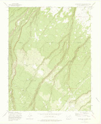
1973 Map of Government Springs
USGS Topo · Published 1976About this map
Uncompahgre National Forest dominates this section of the San Juan Mountains drainage, where the landscape is defined by deep incisions like Happy Canyon and numerous essential water sources. This 1973 field-checked study details the complex hydrology of the high mesa country, following the paths of Dolores Creek and Horsefly Creek as they cut through the terrain. The network of high-altitude routes, including Dave Wood Road and the Paradox Road, suggests a history of timber access and ranching movement across the Montrose and Ouray county lines. Smaller named features such as Dewdrop Springs, Branson Spring, and Brown Spring provide specific points of interest for those tracing old pack trails and the seasonal water availability that dictated land use in this corner of Colorado.
Find a feature on this map
22 named features on this map. Tap any name to fly to it.
Don’t see what you’re looking for? This feature index may not catch every label — zoom into the map to look around manually.
Map Details
Editions of this 1973 Government Springs Map
3 editions found
Other maps of this area

1909 · Montrose
USGS Topo · 1:125,000

1911 · Montrose
USGS Topo · 1:125,000

1956 · Montrose
USGS Topo · 1:250,000

1956 · Moab
USGS Topo · 1:250,000

1959 · Moab
USGS Topo · 1:250,000

1959 · Montrose
USGS Topo · 1:250,000

1960 · Montrose
USGS Topo · 1:250,000

1960 · Moab
USGS Topo · 1:250,000

1962 · Moab
USGS Topo · 1:250,000
1962 · Montrose East
USGS Topo · 1:24,000