
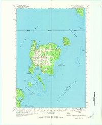
2022 Map of Green Island
USGS Topo · Published 2022About this map
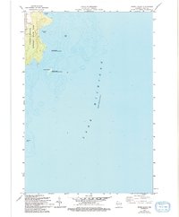
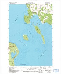
Green Island sits at the maritime intersection of three major regional counties in the waters of Green Bay. This survey captures the isolated landmass and its surrounding nautical environment, where the boundaries of Menominee County, Michigan, and Marinette and Door counties in Wisconsin converge. The map is defined primarily by the open expanse of Lake Michigan, emphasizing the island's role as a distinct navigational landmark in the bay. The precise boundary lines cutting across the water highlight the complex jurisdictional divisions of the Great Lakes, showing how these invisible lines segment the water between different states and local governments.
Find a feature on this map
8 named features on this map. Tap any name to fly to it.
Don’t see what you’re looking for? This feature index may not catch every label — zoom into the map to look around manually.
Map Details
Editions of this 2022 Green Island Map
This is the sole edition of this map. No revisions or reprints were ever made.
Historical Maps of Egg Harbor Through Time
43 maps found

1960 Jacksonport
Door County, WI
1960 Washington Island
Door County, WI

1961 Chambers Island
Door County, WI

1978 Brussels
Door County, WI
1978 Namur
Door County, WI

1981 Idlewild
Door County, WI

1981 Institute
Door County, WI
1981 Sturgeon Bay East
Door County, WI

1981 Sturgeon Bay West
Door County, WI

1982 Algoma NE
Door County, WI

1982 Baileys Harbor East
Door County, WI

1982 Baileys Harbor West
Door County, WI
1982 Chambers Island
Door County, WI

1982 Green Island
Door County, WI

1982 Jacksonport
Door County, WI

1982 Jacksonport SW
Door County, WI

1982 Little Sturgeon SW
Door County, WI
1982 Spider Island
Door County, WI
1982 Washington Island NE
Door County, WI
1982 Washington Island NW
Door County, WI
1982 Washington Island SE
Door County, WI
1982 Washington Island SW
Door County, WI
1984 Washington Island
Door County, WI

2022 Algoma NE
Door County, WI

2022 Baileys Harbor East
Door County, WI

2022 Baileys Harbor West
Door County, WI

2022 Brussels
Door County, WI

2022 Chambers Island
Door County, WI

2022 Chambers Island NW
Door County, WI
2022 Green Island
Door County, WI

2022 Idlewild
Door County, WI

2022 Institute
Door County, WI

2022 Jacksonport
Door County, WI

2022 Jacksonport SW
Door County, WI

2022 Little Sturgeon SW
Door County, WI

2022 Namur
Door County, WI
2022 Spider Island
Door County, WI

2022 Sturgeon Bay East
Door County, WI

2022 Sturgeon Bay West
Door County, WI

2022 Washington Island NE
Door County, WI

2022 Washington Island NW
Door County, WI

2022 Washington Island SE
Door County, WI

2022 Washington Island SW
Door County, WI