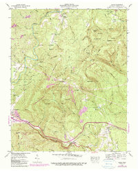
1946 Map of Ozone
USGS Topo · Published 1990About this map
Ozone Falls State Natural Area and the Crab Orchard Mountains define this high-altitude landscape in the middle of the twentieth century. The terrain is marked by significant topographic relief, from Ditney Knob to the deep cut of Renfro Hollow. Transportation through these gaps is centered on the historic Old Walton Road, also designated as the Broadway of America, which runs parallel to the Southern railroad line. Industrial activity is visible in numerous quarries and strip mines that punctuate the ridges near Crab Orchard and Ellis Mtn. Family and community history is preserved in small burial grounds such as Wheeler Cem, King Cem, and McNeil Cem. The eastern portion of the sheet is dominated by the Cumberland Plateau, where Lake Waldensia and the settlement of Daysville sit among a dense network of creek branches and mountain gaps.
Find a feature on this map
95 named features on this map. Tap any name to fly to it.
Don’t see what you’re looking for? This feature index may not catch every label — zoom into the map to look around manually.
Map Details
Editions of this 1946 Ozone Map
2 editions found
Other maps of this area

1887 · Kingston
USGS Topo · 1:125,000

1891 · Kingston
USGS Topo · 1:125,000

1893 · Kingston
USGS Topo · 1:125,000

1895 · Wartburg
USGS Topo · 1:125,000

1896 · Wartburg
USGS Topo · 1:125,000

1935 · Rockwood
USGS Topo · 1:24,000

1935 · Lancing
USGS Topo · 1:24,000

1936 · Hebbertsburg
USGS Topo · 1:24,000

1936 · Fox Creek
USGS Topo · 1:24,000

1936 · Roddy
USGS Topo · 1:24,000