1890s Maps of New Mexico
Explore 28 historic maps of New Mexico from the 1890s. These maps offer a rare glimpse into what life looked like during the 1890s — showing old roads, neighborhoods, homes, and landmarks that have changed or disappeared over time.
Whether you're researching your family's past, planning a metal detecting trip, or studying how New Mexico's landscape evolved across the 1890s, these high-resolution maps are a powerful tool for exploring the history of this region.
- Focus on a specific era: All maps on this page are from the 1890s, giving you a focused view of this time period.
- See what’s changed: Compare century-old streets, trails, and buildings to today's modern landscape using overlays and satellite layers.
- Research with precision: Use these maps for genealogy, historical research, land use analysis, or educational projects.
- View, download, or print: Maps are fully viewable online in high resolution, and can be downloaded or printed for your own records.
Start exploring New Mexico's history through authentic maps from the 1890s. This is your window into the past.
New Mexico maps
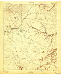
(28)- 1890 Map of Jemes
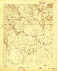
 1890 Jemes1890 Print · USGSUpper New Mexico in the late nineteenth century was a land of high mesas and ancient pueblo sites along the Jemes Creek drainage. Researchers can trace the early layout of Jemes Pueblo, the location of the San Miguel Mine, and traditional springs like Ojo del Oso.2 unique versions available
 - 1890 Map of Bernal, 1956 Print
 1890 Bernal1956 Print · USGSSettlements along the Pecos River valley and the critical rail corridor of the late nineteenth century define this New Mexico landscape. Researchers can trace the early rail stops and traditional plazas of San Miguel, Old Bernal, and Anton Chico.
 - 1891 Map of Bernal
 1891 Bernal1891 Print · USGSNorthern New Mexico's river valleys and mesa lands are captured here just as the railroad began transforming the territory's commerce. Genealogists can trace family roots in historic plazas like San Miguel, La Cuesta, and San Jose before modern development changed these rural corridors.
 - 1891 Map of Las Cruces
 1891 Las Cruces1891 Print · USGSThe Mesilla Valley and Organ Mountains are shown here during the late territorial era, when the railroad was transforming the region. Genealogists and historians can trace early settlements like Mesilla, Fort Selden, and the mining hub at Organ City.
 - 1891 Map of Las Vegas
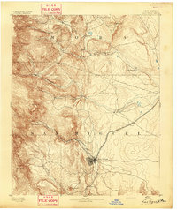
 1891 Las Vegas1891 Print · USGSNorthern New Mexico's transition from frontier outposts to a rail-connected territory is visible in this survey from the late nineteenth century. Genealogists and historians can trace the foundations of Las Vegas and its connection to Fort Union and Hot Springs.
 - 1892 Map of San Pedro
 1892 San Pedro1892 Print · USGSNew Mexico's high desert and mountain mining districts come alive in the late nineteenth century as the rail lines reached the interior. Genealogists and historians can trace old wagon routes and rail stops near Dolores, the mining activity at Golden, and early adobe settlements like Algodones and San Pedro.5 unique versions available
 - 1892 Map of Fort Defiance
 1892 Fort Defiance1892 Print · USGSNorthern Arizona in the late nineteenth century remains a frontier of isolated outposts and high desert mesas. Trace the path of the A & P R R through Sanders or locate the remote station at Pueblo Colorado and the springs at Jacobs Well.6 unique versions available
 - 1892 Map of Jemes
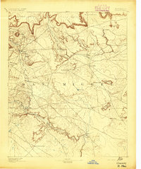
 1892 Jemes1892 Print · USGSThe high canyons and pueblos of northern New Mexico are documented here in the late 1880s, shortly after the region's territorial reorganization. Researchers can trace the early footprint of Jemes Pueblo, locate the San Miguel Mine, and identify remote springs like Ojo del Espiritu Santo.4 unique versions available
 - 1892 Map of Santa Clara
 1892 Santa Clara1892 Print · USGSUpper New Mexico at the end of the nineteenth century reveals a landscape shaped by the Rio Grande and the arrival of the rails. Genealogists and historians can trace traditional settlements like San Ildefonso and Peña Blanca alongside the burgeoning Santa Fé Southern Railway.4 unique versions available
 - 1892 Map of St Johns
 1892 St Johns1892 Print · USGSArizona's eastern frontier is documented here in the late nineteenth century as cattle ranching and early settlements followed the path of the river. Genealogists and historians can trace the foundations of St Johns and Springerville or locate long-standing sites like Erastus and Windmill Ranch.5 unique versions available
 - 1892 Map of Watrous
 1892 Watrous1892 Print · USGSNortheastern New Mexico comes into focus during the expansion of the western frontier, showing the critical junction of the railroad and the river. Trace nineteenth-century ranching life and travel stops at Watrous, the O. K. Ranch, and a remote Blacksmith Shop.
 - 1892 Map of Corazon
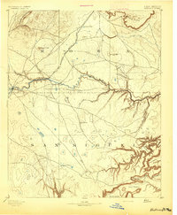
 1892 Corazon1892 Print · USGSSan Miguel County in the early 1890s reveals a territory of high mesas and vital water sources before modern development. Genealogists and researchers can locate early plazas and villages such as Chaperito, Aguila, and Las Colonias, or trace family landmarks like Cabra Spring.2 unique versions available
 - 1892 Map of Wingate
 1892 Wingate1892 Print · USGSNorthwestern New Mexico territory comes to life during the expansion of the rail era, centered on the strategic military and trade routes of the high desert. Researchers can trace the path of the Atlantic and Pacific Railroad past Fort Wingate and through early settlements like Gallup and Old Zuni.4 unique versions available
 - 1892 Map of Mt Carrizo
 1892 Mt Carrizo1892 Print · USGSSoutheastern Colorado in the early 1890s remained a landscape of high mesas and vital water holes. Historians can trace the original topography of Las Animas and Baca counties, locating critical sites like Carrizo Springs and Willow Spring.7 unique versions available
 - 1892 Map of Chaco
 1892 Chaco1892 Print · USGSNorthwestern New Mexico in the late nineteenth century reveals the early river-side foundations of the Four Corners region. Genealogists and historians can trace the development of Farmington, Aztec, and Jewett along the San Juan River and the high desert outpost of Seven Lakes.5 unique versions available
 - 1892 Map of Canyon De Chelly
 1892 Canyon De Chelly1892 Print · USGSApache County's high desert and deep sandstone canyons are documented here in the early 1890s, shortly after the initial 1883 survey. Modern researchers can trace the intricate drainages of Canyon De Chelly and find early water sources like Hospitito Spring and Tatezaka Tank.5 unique versions available
 - 1892 Map of Mt. Taylor, 1896 Print
 1892 Mt. Taylor1896 Print · USGSNorthwestern New Mexico in the late nineteenth century was a territory of rail expansion and ancient volcanic landmarks. Researchers can trace the path of the Atlantic and Pacific Railroad past Old Fort Wingate and the pueblo at Laguna.
 - 1893 Map of Las Vegas
 1893 Las Vegas1893 Print · USGSSan Miguel and Mora counties are captured here in the final decade of the nineteenth century as the railroad transformed the territory. Trace early travel routes through Las Vegas and locate historic outposts like Fort Union and La Cueva.5 unique versions available
 - 1893 Map of Las Cruces
 1893 Las Cruces1893 Print · USGSSettlements along the Rio Grande flourished in the 1890s as the railroad arrived in Doña Ana County. Genealogists can trace family roots in Mesilla, Las Cruces, and Santa Tomaz, or locate the historic site of Fort Selden.4 unique versions available
 - 1893 Map of Albuquerque
 1893 Albuquerque1893 Print · USGSThe Rio Grande valley in the late nineteenth century is a study in river-fronting settlements and the emerging rail economy. Genealogists can trace the early footprints of Albuquerque, Bernalillo, and the traditional community at Artisco.5 unique versions available
 - 1894 Map of Corazon
 1894 Corazon1894 Print · USGSSan Miguel county in the 1890s was a landscape of high mesas and vital river settlements. Genealogists and historians can trace early territory life through named springs and remote outposts like Chaperito, Las Colonias, and Concha Spring.5 unique versions available
 - 1894 Map of Watrous
 1894 Watrous1894 Print · USGSNorthern New Mexico at the end of the nineteenth century was a landscape of pioneering rail lines and cattle ranches. You can trace the Atchison Topeka and Santa Fe Railroad as it services Watrous and Shoemaker or locate the remote O.K. Ranch.5 unique versions available
 - 1894 Map of Santa Fe
 1894 Santa Fe1894 Print · USGSSanta Fe and its surrounding high-country villages appear here during the territorial era of the late nineteenth century. Genealogists and historians can trace the routes of early railroads and locate specific landmarks like Old Fort Marcy, Gonzales Ranch, and Tesuque Pueblo.5 unique versions available
 - 1894 Map of Bernal
 1894 Bernal1894 Print · USGSSan Miguel County at the end of the nineteenth century is captured here as the railroad began to reshape the old river settlements. Genealogists can trace family roots in historic villages like Old Bernal, Anton Chico, and La Liendre.4 unique versions available
 - 1894 Map of Lamy
 1894 Lamy1894 Print · USGSNorthern New Mexico in the late nineteenth century centers on the high-desert corridor of the Atchison Topeka and Santa Fe RR. Genealogists and historians can trace early ranching sites like Gomez Ranch and rail stops from Lamy to Fulton.5 unique versions available
Showing maps 1-25 of 28
Top cities of New Mexico
- Albuquerque historical maps
- Las Cruces historical maps
- Rio Rancho historical maps
- Santa Fe historical maps
- Roswell historical maps
- Farmington historical maps
See more
Top counties of New Mexico
- Bernalillo County historical maps
- Doña Ana County historical maps
- Santa Fe County historical maps
- Sandoval County historical maps
- San Juan County historical maps
- McKinley County historical maps
See more
Frequently asked questions
- What are the different types of historical maps available for New Mexico?
- What is the oldest map of New Mexico?
- Where can I purchase historical maps of New Mexico for my home or office?
- Where can I download high-res historical maps of New Mexico?
- Are there historical topographic maps available for New Mexico?
- Is there historical aerial imagery available for New Mexico?
- Where are historical maps of New Mexico sourced from?