1900-1909 Maps of New Mexico
Explore 4 historic maps of New Mexico from 1900-1909. These maps offer a rare glimpse into what life looked like during the 1900s — showing old roads, neighborhoods, homes, and landmarks that have changed or disappeared over time.
Whether you're researching your family's past, planning a metal detecting trip, or studying how New Mexico's landscape evolved across the 1900s, these high-resolution maps are a powerful tool for exploring the history of this region.
- Focus on a specific era: All maps on this page are from the 1900s, giving you a focused view of this time period.
- See what’s changed: Compare century-old streets, trails, and buildings to today's modern landscape using overlays and satellite layers.
- Research with precision: Use these maps for genealogy, historical research, land use analysis, or educational projects.
- View, download, or print: Maps are fully viewable online in high resolution, and can be downloaded or printed for your own records.
Start exploring New Mexico's history through authentic maps from the 1900s. This is your window into the past.
New Mexico maps
(4)- 1906 Map of Socorro
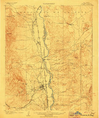 1906 Socorro1906 Print · USGSSocorro and the Rio Grande valley are captured here at the dawn of the twentieth century, as the railroad and mining industries reshaped the region. Genealogists and researchers can locate old sites like the School of Mines, the Dewey Mine, and the river crossing at Ford and Ferry.3 unique versions available
 - 1908 Map of Ignacio
 1908 Ignacio1908 Print · USGSLa Plata County and the Southern Ute lands are captured here in the first decade of the twentieth century. Genealogists and rail historians can trace the early growth of Durango and locate rural landmarks such as the Ute Indian Agency, Pinkerton Hot Springs, and the Oxford PO.3 unique versions available
 - 1909 Map of Silver City
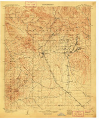 1909 Silver City1909 Print · USGSSilver City and the surrounding mining districts are shown at their industrial peak before the First World War. Researchers can trace early railroad spurs to camps like Santa Rita and Fierro, or locate the expansive Fort Bayard Military Reservation.2 unique versions available
 - 1909 Map of Gallina
 1909 Gallina1909 Print · USGSUpper New Mexico at the end of the territorial era is captured here, showing the remote ranching and mining country along the Continental Divide. Genealogists and historians can locate early homesteads like Hart Ranch, the mining-era Copper City, and ancient Cliff Dwellings.2 unique versions available
End of results
Showing maps 1-4 of 4
Top cities of New Mexico
- Albuquerque historical maps
- Las Cruces historical maps
- Rio Rancho historical maps
- Santa Fe historical maps
- Roswell historical maps
- Farmington historical maps
See more
Top counties of New Mexico
- Bernalillo County historical maps
- Doña Ana County historical maps
- Santa Fe County historical maps
- Sandoval County historical maps
- San Juan County historical maps
- McKinley County historical maps
See more
Frequently asked questions
- What are the different types of historical maps available for New Mexico?
- What is the oldest map of New Mexico?
- Where can I purchase historical maps of New Mexico for my home or office?
- Where can I download high-res historical maps of New Mexico?
- Are there historical topographic maps available for New Mexico?
- Is there historical aerial imagery available for New Mexico?
- Where are historical maps of New Mexico sourced from?