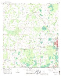
1994 Map of Cottondale West
USGS Topo · Published 1995About this map
Cottondale and the surrounding rural landscape of Jackson and Washington counties define this 1994 revision. The map details a region characterized by specialized water bodies like Drummond Bay, Big Bay, and Melvin Bay, alongside smaller ponds such as Grassy Pond and Holland Pond. A network of country churches serves as the primary social landmarks for local history and genealogy, including Glass Ch, Pilgrim Rest Ch, and Friendship Ch. The presence of several Claypits and the Cottondale Airport suggests a mix of local industrial extraction and regional transport development. Subtle terrain features like Still Hammock and Rock Hill break up the low-lying wetlands, while watercourses like Alligator Creek and Gilberts Mill Creek drain the countryside. This updated topographic study preserves the placement of family-named landmarks and rural settlements like Glass and Lovewood before late-century growth patterns shifted the area's layout.
Find a feature on this map
36 named features on this map. Tap any name to fly to it.
Don’t see what you’re looking for? This feature index may not catch every label — zoom into the map to look around manually.
Map Details
Editions of this 1994 Cottondale West Map
This is the sole edition of this map. No revisions or reprints were ever made.
Other maps of this area

1950 · Chipley
USGS Topo · 1:24,000

1950 · Wausau
USGS Topo · 1:24,000

1951 · Graceville
USGS Topo · 1:24,000

1951 · Chipley
USGS Topo · 1:24,000

1951 · Wausau
USGS Topo · 1:24,000

1952 · Kynesville
USGS Topo · 1:24,000

1952 · Cottondale East
USGS Topo · 1:24,000

1952 · Campbellton
USGS Topo · 1:24,000

1952 · Cottondale West
USGS Topo · 1:24,000

1952 · Sills
USGS Topo · 1:24,000