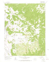
1963 Map of Dallas
USGS Topo · Published 1966About this map
Orvis Hot Spring and the settlement of Dallas anchor this mountain landscape in the early 1960s, where the Uncompahgre River flows through Ouray County. The geography is defined by a complex network of water management and transport, including Alkali Ditch No 1 and Alkali Ditch No 2, alongside the Denver and Rio Grande Western Railroad Grade. Higher elevations are marked by the Uncompahgre National Forest, reaching toward peaks like Courthouse Mountain and Onion Hill. This survey captures the transition from the river valley's agricultural infrastructure, such as the County Fairground and Gaging Sta, to the high-country drainages of Nate Creek and Cow Creek. For local historians, it provides clear documentation of mid-century land use, including a Landing Strip and various named gulches and draws that shaped the area's development.
Find a feature on this map
44 named features on this map. Tap any name to fly to it.
Don’t see what you’re looking for? This feature index may not catch every label — zoom into the map to look around manually.
Map Details
Editions of this 1963 Dallas Map
4 editions found
Other maps of this area

1902 · Ouray
USGS Topo · 1:62,500

1904 · Ouray
USGS Topo · 1:62,500

1909 · Montrose
USGS Topo · 1:125,000

1911 · Montrose
USGS Topo · 1:125,000

1955 · Ouray
USGS Topo · 1:24,000

1956 · Montrose
USGS Topo · 1:250,000

1959 · Montrose
USGS Topo · 1:250,000

1960 · Montrose
USGS Topo · 1:250,000
1963 · Buckhorn Lakes
USGS Topo · 1:24,000
1963 · Courthouse Mountain
USGS Topo · 1:24,000