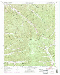
1951 Map of Graves Spring
USGS Topo · Published 1970About this map
Graves Spring sits at the intersection of several Tennessee counties, where the ridges of Perry, Lewis, and Hickman meet. This mid-century landscape is defined by its drainage patterns, with life organized around the deep hollows and creek beds. The Tennessee Valley Authority's work here captures a rural network of family-named landmarks and essential community institutions. To the north, Coon Creek Ch and Barber Cem anchor a small valley community, while further south, Sinking Creek Church serves as a key landmark. The importance of local education in this remote terrain is evident through the presence of both the Upper Brush Creek School and the Upper Coon Creek School. Many residents of this era relied on these narrow valleys, or hollows, such as Poplin Hollow and Mulberry Hollow, for both shelter and transport between the higher ridges like Sassafras Stand Ridge.
Find a feature on this map
96 named features on this map. Tap any name to fly to it.
Don’t see what you’re looking for? This feature index may not catch every label — zoom into the map to look around manually.
Map Details
Editions of this 1951 Graves Spring Map
3 editions found
Other maps of this area

1905 · Waynesboro
USGS Topo · 1:125,000

1936 · Riverside
USGS Topo · 1:24,000

1936 · Graves Spring
USGS Topo · 1:24,000

1936 · Pleasantville
USGS Topo · 1:24,000

1936 · Beaverdam Springs
USGS Topo · 1:24,000

1936 · Linden
USGS Topo · 1:24,000

1936 · Leatherwood
USGS Topo · 1:24,000

1936 · Chestnut Grove
USGS Topo · 1:24,000

1936 · Kimmins
USGS Topo · 1:24,000

1936 · Topsy
USGS Topo · 1:24,000