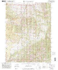
1998 Map of James Peak
USGS Topo · Published 2001About this map
James Peak and the high ridges of the Cache National Forest dominate this late-twentieth-century landscape, marking the transition between the Logan Ogden Ranger District and the mountain watersheds of northern Utah. The terrain is defined by a dense network of drainages including Davenport Creek, McKenzie Creek, and the South Fork Little Bear River, illustrating the complex hydrology of the Bear River Range.
Find a feature on this map
40 named features on this map. Tap any name to fly to it.
Don’t see what you’re looking for? This feature index may not catch every label — zoom into the map to look around manually.
Map Details
Editions of this 1998 James Peak Map
This is the sole edition of this map. No revisions or reprints were ever made.
Other maps of this area

1914 · Logan
USGS Topo · 1:125,000

1916 · Logan
USGS Topo · 1:125,000

1954 · Ogden
USGS Topo · 1:250,000

1955 · Paradise
USGS Topo · 1:24,000

1955 · Mantua
USGS Topo · 1:24,000

1955 · Huntsville
USGS Topo · 1:24,000

1955 · James Peak
USGS Topo · 1:24,000

1955 · North Ogden
USGS Topo · 1:24,000

1955 · Mount Pisgah
USGS Topo · 1:24,000

1958 · Ogden
USGS Topo · 1:250,000
Featured Places
- Sundown Condominiums at Powder Mountain, UT
- Powder Mountain, UT
- Weber County, UT
- Cache County, UT
- Box Elder County, UT