1900-1909 Maps of Kansas
Explore 10 historic maps of Kansas from 1900-1909. These maps offer a rare glimpse into what life looked like during the 1900s — showing old roads, neighborhoods, homes, and landmarks that have changed or disappeared over time.
Whether you're researching your family's past, planning a metal detecting trip, or studying how Kansas's landscape evolved across the 1900s, these high-resolution maps are a powerful tool for exploring the history of this region.
- Focus on a specific era: All maps on this page are from the 1900s, giving you a focused view of this time period.
- See what’s changed: Compare century-old streets, trails, and buildings to today's modern landscape using overlays and satellite layers.
- Research with precision: Use these maps for genealogy, historical research, land use analysis, or educational projects.
- View, download, or print: Maps are fully viewable online in high resolution, and can be downloaded or printed for your own records.
Start exploring Kansas's history through authentic maps from the 1900s. This is your window into the past.
Kansas maps
(10)- 1900 Map of Syracuse
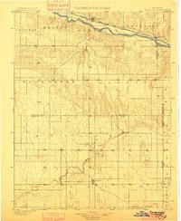 1900 Syracuse1900 Print · USGSWestern Kansas at the turn of the century shows a frontier landscape shaped by the Arkansas River and the arriving railroad. Genealogists and researchers can locate early settlements like Hatton, Edwin, and Gognac along with the path of the Atchison Topeka and Santa Fe.5 unique versions available
 - 1900 Map of Lakin
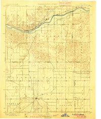 1900 Lakin1900 Print · USGSSouthwestern Kansas at the close of the nineteenth century is defined by the rail corridor along the Arkansas River and the early grid of prairie townships. Genealogists can trace pioneer-era locations like Ulysses and Shockey, or the remote station at Conductor.5 unique versions available
 - 1901 Map of Nowata
 1901 Nowata1901 Print · USGSThe Cherokee Nation in Indian Territory is captured here at the start of the twentieth century, showing the lands that would soon become northeast Oklahoma. Researchers can trace early rail-town growth in Nowata and Bartlesville or locate smaller settlements like Alluwe and Coodys Bluff.2 unique versions available
 - 1901 Map of Vinita
 1901 Vinita1901 Print · USGSIndian Territory at the turn of the century shows a landscape of burgeoning railroad towns and Cherokee Nation settlements. Genealogists can trace family roots in early townsites like Vinita, Bluejacket, and Chelsea or locate rural homesteads near Cabin Creek.2 unique versions available
 - 1901 Map of Cheney, 1910 Print
 1901 Cheney1910 Print · USGSSouth Central Kansas was a landscape of budding rail towns and rural post offices at the turn of the century. Genealogists can trace family roots through now-vanished locales like Stella P.O. and Mona P.O. or early hubs like Cheney and Mt. Hope.2 unique versions available
 - 1904 Map of Iola
 1904 Iola1904 Print · USGSSoutheast Kansas at the start of the century was a land defined by the iron rail and the winding Neosho River. Genealogists and historians can trace the early footprints of Iola, Chamute, and Erie, alongside smaller depots like Gas and Savonburg.4 unique versions available
 - 1905 Map of Independence
 1905 Independence1905 Print · USGSSoutheastern Kansas at the turn of the century is a landscape of expanding rail-hubs and river commerce. Genealogists can trace early homesteads and rail-stops like Lafontaine, Havana, and Sycamore, or locate family landmarks near Table Mound and the Verdigris River.4 unique versions available
 - 1907 Map of Wyandotte, 1954 Print
 1907 Wyandotte1954 Print · USGSThe Tri-State border region at the start of the twentieth century shows a landscape of river ferries and early rail towns. Trace the locations of family landmarks like Hickory Grove Church, Goad Eagle Ferry, and rural schools from Afton to Seneca.2 unique versions available
 - 1909 Map of Wyandotte
 1909 Wyandotte1909 Print · USGSNortheastern Oklahoma’s river valleys and prairies are captured here just after statehood, during a period of rapid rail expansion and tribal land transition. Researchers can trace early river crossings like Rodwhite Ferry and locate historic community centers such as Hickory Grove Church or the Bluejacket School.2 unique versions available
 - 1909 Map of Pawhuska, 1957 Print
 1909 Pawhuska1957 Print · USGSOsage County comes alive in this turn-of-the-century survey of the terrain around Pawhuska and its neighboring rail towns. Trace the paths of three major railroads as they pass through Barnsdall, find landmarks like Daltons Caves, or locate the White Swan Ford.
End of results
Showing maps 1-10 of 10
Top cities of Kansas
- Wichita historical maps
- Overland Park historical maps
- Kansas City historical maps
- Olathe historical maps
- Topeka historical maps
- Lawrence historical maps
See more
Top counties of Kansas
- Johnson County historical maps
- Sedgwick County historical maps
- Shawnee County historical maps
- Wyandotte County historical maps
- Douglas County historical maps
- Riley County historical maps
See more
Frequently asked questions
- What are the different types of historical maps available for Kansas?
- What is the oldest map of Kansas?
- Where can I purchase historical maps of Kansas for my home or office?
- Where can I download high-res historical maps of Kansas?
- Are there historical topographic maps available for Kansas?
- Is there historical aerial imagery available for Kansas?
- Where are historical maps of Kansas sourced from?