1990s Maps of Kansas
Explore 40 historic maps of Kansas from the 1990s. These maps offer a rare glimpse into what life looked like during the 1990s — showing old roads, neighborhoods, homes, and landmarks that have changed or disappeared over time.
Whether you're researching your family's past, planning a metal detecting trip, or studying how Kansas's landscape evolved across the 1990s, these high-resolution maps are a powerful tool for exploring the history of this region.
- Focus on a specific era: All maps on this page are from the 1990s, giving you a focused view of this time period.
- See what’s changed: Compare century-old streets, trails, and buildings to today's modern landscape using overlays and satellite layers.
- Research with precision: Use these maps for genealogy, historical research, land use analysis, or educational projects.
- View, download, or print: Maps are fully viewable online in high resolution, and can be downloaded or printed for your own records.
Start exploring Kansas's history through authentic maps from the 1990s. This is your window into the past.
Kansas maps
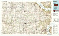
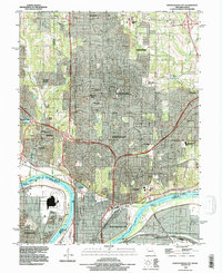
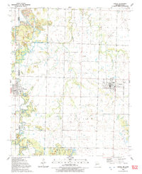
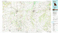
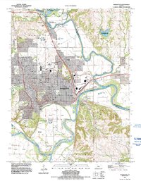
(40)- 1990 Map of Chanute
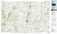 1990 Chanute1990 Print · USGSSoutheast Kansas at the start of the nineties reveals a landscape of river-valley towns and agricultural hubs. Researchers can trace the paths of the Missouri Pacific RR through Iola or locate family roots near Savonburg, Thayer, and Buffalo.
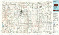
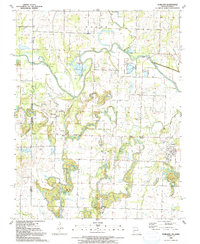
 - 1990 Map of Garnett
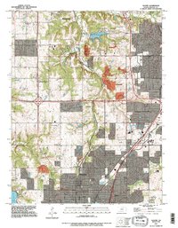
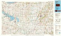 1990 Garnett1990 Print · USGSEast-central Kansas was a landscape of major reservoirs and established rail towns during the 1990s. Genealogists and historians can trace the paths of the Missouri Pacific Railroad and the Atchison Topeka and Santa Fe Railway through towns like Garnett and Silkville.
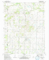
 - 1990 Map of El Dorado
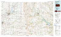 1990 El Dorado1990 Print · USGSButler and Greenwood counties are shown here in the early nineties, featuring a landscape defined by the Walnut River basin and the Kansas Turnpike corridor. Researchers can trace the rail lines of the AT & SF RR and locate smaller settlements such as Midian, Smileyberg, and Pickrell Corner.
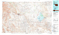
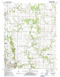
 - 1990 Map of Manhattan
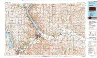 1990 Manhattan1990 Print · USGSThe Kansas river valley and the Flint Hills uplands are captured here in the late twentieth century as the region balanced military expansion and water management. Trace the historic Union Pacific rail line through river towns like Wamego and St Marys, or explore the sprawling Fort Riley Military Reservation.
 - 1990 Map of Wichita
 1990 Wichita1990 Print · USGSThe Wichita metropolitan area and its surrounding agricultural plains are captured in the late twentieth century, showing a landscape defined by rapid suburban expansion and massive water projects. Genealogists can locate family landmarks in small towns like Garden Plain and Clonmel, or trace the development around Cheney Reservoir and McConnell Air Force Base.
 - 1990 Map of Atchison
 1990 Atchison1990 Print · USGSNortheast Kansas and northwest Missouri meet at the winding Missouri River in this late twentieth-century record of a historic border region. Researchers can trace the paths of the Pony Express Trail and the Atchison Topeka and Santa Fe Railway while locating landmarks like St Benedicts College and Mount Vernon Cem.
 - 1990 Map of Salina
 1990 Salina1990 Print · USGSThe Smoky Hill River valley thrived in the late twentieth century as a vital crossroads of Kansas industry and education. Genealogists can trace family roots through the detailed plots of Elmwood Cem and Mt Calvary Cem or locate the historic campus of Bethany College.
 - 1990 Map of Coffeyville
 1990 Coffeyville1990 Print · USGSSoutheast Kansas in the late twentieth century is defined by its industrial sites and river valley rail hubs. Genealogists and historians can trace the infrastructure of the Army Ammunition Plant, the local graves at Fairview Cemetery, and the extensive Strip Mine operations.
 - 1990 Map of Alva
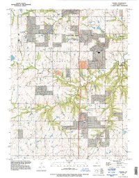
 1990 Alva1990 Print · USGSThe Oklahoma-Kansas borderlands in the 1990s reveal a landscape shaped by vast salt flats and crucial rail corridors. Genealogists and historians can trace the growth of Alva and Waynoka or locate landmarks like the State School for Boys and Little Sahara State Park.
 - 1990 Map of North Kansas City, 1996 Print
 1990 North Kansas City1996 Print · USGSAs North Kansas City and Gladstone expanded in the 1990s, this survey captured the shifting suburban landscape across the Clay County line. Trace family sites at Barry Cem and New Stark Cem, or the riverfront near Goose Island.
 - 1991 Map of Joplin
 1991 Joplin1991 Print · USGSThe tri-state mining district and the Ozark foothills meet in the early 1990s as industrial land transitions into conservation areas. Genealogists and historians can trace the growth of Joplin and Baxter Springs or locate rural sites like Mount Hope Cem and Blue Mound.
 - 1991 Map of Hume
 1991 Hume1991 Print · USGSThe Missouri-Kansas border area near Hume is captured here during the late twentieth century, showing a landscape defined by state-line boundaries and rural heritage. Researchers can locate family sites and landmarks like Lawrence Cem, Amos, and Rocky Mound.
 - 1991 Map of Deerfield
 1991 Deerfield1991 Print · USGSThe Missouri-Kansas borderlands in the early 1990s show a landscape of rural townships and active extraction. Genealogists and researchers can trace family landmarks like Logan Cem and Clayton Ch or follow the path of the Marmaton River past Eve.
 - 1991 Map of Liberal
 1991 Liberal1991 Print · USGSThe Missouri-Kansas border comes alive in the early nineties, centered on the community of Liberal. Genealogists and historians can trace local family roots through Rosebank Cem and Liberal Cem or explore the early boundaries of Prairie State Park.
 - 1991 Map of Worland
 1991 Worland1991 Print · USGSThe Missouri-Kansas borderlands come into focus in the early nineties, showing a landscape shaped by river engineering and rural industry. Researchers can trace family sites at Salem Cem or locate the defunct Old Railroad Grade near Worland and Tiger.
 - 1991 Map of Richards
 1991 Richards1991 Print · USGSVernon County and the Kansas borderlands appear in detail in the early nineties, showing a landscape defined by the Little Osage River. Researchers can trace the path of the Old Railroad Grade or locate family plots at Richland Cem and East Liberty Cem.
 - 1991 Map of Garland
 1991 Garland1991 Print · USGSThe Kansas-Missouri border comes alive in the early nineties, showcasing the rural landscapes of Bourbon and Crawford Counties. Genealogists can locate several historic burial sites like Davis Cem and Shiloh Cem, or trace the path of Dry Wood Creek past the town of Arcadia.
 - 1991 Map of Nevada
 1991 Nevada1991 Print · USGSThis borderland region in the early nineties captures the transition from Kansas plains to Missouri timber. Researchers can trace family history through Bunn Cemetery, locate the Camp Clark Military Reservation, and explore rail towns like Nevada and Fort Scott.
 - 1991 Map of Lenexa, 1995 Print
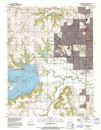
 1991 Lenexa1995 Print · USGSJohnson County is shown in the midst of its late-century expansion, capturing the suburban transformation of Lenexa and Overland Park. Trace the development of local institutions like Johnson County Community College or the residential growth near Turkey Creek.
 - 1991 Map of Olathe, 1995 Print
 1991 Olathe1995 Print · USGSJohnson County was experiencing rapid suburban transformation during the 1990s as it grew around traditional hubs. Genealogists and historians can trace institutional sites like the State School For The Deaf and County Farm, alongside older locales like Monticello and Lackmans.
 - 1991 Map of Milford, 1995 Print
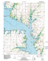 1991 Milford1995 Print · USGSMilford and the shores of the Republican River are shown here in the early nineties as the reservoir transformed the landscape. Researchers can trace the town of Milford and its Milford Cem, while exploring the vast Fort Riley Military Reservation.
 - 1991 Map of Stilwell, 1995 Print
 1991 Stilwell1995 Print · USGSSouthern Johnson County during the 1990s reveals a landscape of expanding suburbs and historic crossroads. Researchers can locate early township nodes like Stilwell, Morse, and Aubry or trace watercourses like the Blue River and Coffee Creek.
 - 1991 Map of Manhattan, 1995 Print
 1991 Manhattan1995 Print · USGSManhattan and the Kansas River valley are shown here in the early nineties, centered on the growing campus of Kansas State University. Researchers can locate several burial sites including Sunset Cem and St Patricks Cem, alongside landmarks like Bluemont Hill and the Union Pacific line.
 - 1991 Map of Kansas City, 1995 Print
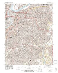 1991 Kansas City1995 Print · USGSGreater Kansas City in the 1990s showcases a dense network of historic neighborhoods, river crossings, and major cemeteries. Researchers can trace family history at Union Cemetery or Elmwood Cemetery and explore the industrial roots of Leeds.2 unique versions available
 - 1991 Map of Lawrence West, 1995 Print
 1991 Lawrence West1995 Print · USGSLawrence and its western outskirts are shown here during a period of significant growth in the early nineties. Researchers can trace the development of the University of Kansas, the shoreline of Clinton Lake, and rural landmarks like Richland Cem.
Showing maps 1-25 of 40
Top cities of Kansas
- Wichita historical maps
- Overland Park historical maps
- Kansas City historical maps
- Olathe historical maps
- Topeka historical maps
- Lawrence historical maps
See more
Top counties of Kansas
- Johnson County historical maps
- Sedgwick County historical maps
- Shawnee County historical maps
- Wyandotte County historical maps
- Douglas County historical maps
- Riley County historical maps
See more
Frequently asked questions
- What are the different types of historical maps available for Kansas?
- What is the oldest map of Kansas?
- Where can I purchase historical maps of Kansas for my home or office?
- Where can I download high-res historical maps of Kansas?
- Are there historical topographic maps available for Kansas?
- Is there historical aerial imagery available for Kansas?
- Where are historical maps of Kansas sourced from?