1890s Maps of Kansas
Explore 90 historic maps of Kansas from the 1890s. These maps offer a rare glimpse into what life looked like during the 1890s — showing old roads, neighborhoods, homes, and landmarks that have changed or disappeared over time.
Whether you're researching your family's past, planning a metal detecting trip, or studying how Kansas's landscape evolved across the 1890s, these high-resolution maps are a powerful tool for exploring the history of this region.
- Focus on a specific era: All maps on this page are from the 1890s, giving you a focused view of this time period.
- See what’s changed: Compare century-old streets, trails, and buildings to today's modern landscape using overlays and satellite layers.
- Research with precision: Use these maps for genealogy, historical research, land use analysis, or educational projects.
- View, download, or print: Maps are fully viewable online in high resolution, and can be downloaded or printed for your own records.
Start exploring Kansas's history through authentic maps from the 1890s. This is your window into the past.
Kansas maps
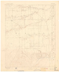
(90)- 1890 Map of Wellington
 1890 Wellington1890 Print · USGSSumner and Cowley counties are captured here in the late nineteenth century as a dense network of railroads and river towns transformed the Kansas prairie. Genealogists and historians can trace the early layouts of Wellington, Oxford, and Geuda Springs before the turn of the century.6 unique versions available
 - 1890 Map of Kansas City
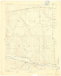
 1890 Kansas City1890 Print · USGSThe Missouri River valley at the turn of the decade shows a booming rail-and-river economy centered on KANSAS CITY. Researchers can trace the early footprints of settlements like White Church, Lansing, and Smithville before modern expansion.2 unique versions available
 - 1890 Map of Granada, 1962 Print
 1890 Granada1962 Print · USGSSoutheast Colorado at the close of the nineteenth century was a landscape of expanding steel and water. Researchers can trace early railroad developments along the Missouri Pacific Railroad and locate pioneer outposts like Ellis Ranch or Granada.
 - 1891 Map of Great Bend
 1891 Great Bend1891 Print · USGSThe Arkansas River valley comes alive in the late nineteenth century as railroads transform the Kansas prairie. Genealogists and historians can trace the early growth of Great Bend, the salt-spring landscapes of Byron, and rail stops like Seward and Heizer.
 - 1891 Map of Medicine Lodge
 1891 Medicine Lodge1891 Print · USGSBarber County appears here during the late nineteenth-century rail expansion, centered on the growth of the Medicine Lodge river valley. Genealogists and researchers can trace early town sites and river crossings like Sun City, Lake City, and the Atchison Topeka and Santa Fe Railroad line.
 - 1891 Map of Albany
 1891 Albany1891 Print · USGSThe Colorado-Kansas borderlands were a crossroads of historic transit in the early 1890s. Genealogists and historians can trace the paths of the Santa Fe Trail and Texas Trail past frontier outposts like Albany and Kline Ranche.
 - 1891 Map of Larned
 1891 Larned1891 Print · USGSLarned and the surrounding Kansas plains were undergoing a rapid transformation into a rail-and-river economy in the late 1880s. Local researchers can trace the growth of Larned at the river forks or follow the path of the Atchison Topeka and Santa Fe Railroad through towns like Rush Centre and Garfield.5 unique versions available
 - 1891 Map of Hutchinson
 1891 Hutchinson1891 Print · USGSCentral Kansas at the close of the frontier era was a landscape of burgeoning rail towns and organized townships. Genealogists and local historians can trace the early footprints of Hutchinson and Mc Pherson alongside vanished locales like King City and Aiken.
 - 1891 Map of Cheney
 1891 Cheney1891 Print · USGSKansas prairie life in the 1890s centered on the arrival of the rails and the flow of the rivers. Genealogists and historians can trace early post offices like Stella P.O. and Mona P.O. or follow the path of the Wichita and Western Railroad through Cheney.2 unique versions available
 - 1891 Map of Anthony
 1891 Anthony1891 Print · USGSSouthern Kansas is captured here in the late nineteenth century as the railroads solidified the prairie's town-and-country layout. Trace the development of early rail hubs like Anthony, Harper, and Hazelton alongside landmarks such as Pilot Knob.6 unique versions available
 - 1891 Map of Clay Center
 1891 Clay Center1891 Print · USGSClay County and northern Dickinson County were defined by competing rail lines in the early 1890s as the river valleys were first being settled. Genealogists and historians can trace the early foundations of towns like Clay Center, Wakefield, and Manchester alongside the Republican River.5 unique versions available
 - 1891 Map of Larned, 1921 Print
 1891 Larned1921 Print · USGSThe Arkansas River valley at the close of the nineteenth century shows a landscape being rapidly transformed by rail and irrigation. Genealogists and historians can trace early prairie life through rail stops like Rush Centre, Garfield, and the hub at Larned.
 - 1892 Map of Ness
 1892 Ness1892 Print · USGSWestern Kansas at the turn of the century reveals a landscape shaped by the Atchison Topeka and Santa Fe Railroad and prairie watercourses. Researchers can locate early post offices and rail stops like Schoharie P.O., Bazine, and Jetmore.
 - 1892 Map of Concordia
 1892 Concordia1892 Print · USGSNorth-central Kansas thrives as a railroad and river corridor in the early 1890s, where the Republican River meets a dense web of competing iron rails. Genealogists and researchers can pinpoint early homesteads near Concordia, Belleville, and vanished rural stops like Seapo or Lake Sibley.4 unique versions available
 - 1892 Map of Kinsley
 1892 Kinsley1892 Print · USGSThe Kansas prairie of Edwards and Kiowa counties is captured here in the late nineteenth century as new railroads transformed the plains into a network of agricultural hubs. Genealogists and historians can trace the early footprints of Greensburg and Kinsley, along with smaller sidings like Mullenville and Brenham.
 - 1892 Map of Meade
 1892 Meade1892 Print · USGSSouthwestern Kansas at the end of the nineteenth century centers on the growing rail hub of Meade. Genealogists and historians can trace early prairie settlements and rail stops like Fowler, Minneola, and the riverside site of Odee.5 unique versions available
 - 1892 Map of Salina
 1892 Salina1892 Print · USGSCentral Kansas at the close of the nineteenth century centers on the booming rail junctions and river valleys of the Smoky Hill region. Genealogists can trace family footprints in riverside settlements like Lindsborg and Assaria or the rail stops of Bavaria and Terra Cotta.6 unique versions available
 - 1892 Map of Dodge
 1892 Dodge1892 Print · USGSWestern Kansas at the close of the nineteenth century centers on the vital Arkansas River valley and its competing rail lines. Genealogists and historians can trace early prairie settlements like Montezuma, Ensign, and Cimarron alongside the namesake hub of Dodge.4 unique versions available
 - 1892 Map of Minneapolis
 1892 Minneapolis1892 Print · USGSOttawa and Cloud counties appear here in the 1890s as the railroad and river networks solidified the region's agricultural layout. Genealogists and researchers can trace early homesteads and town sites along the Solomon River and railroads serving Minneapolis, Delphos, and Glasco.5 unique versions available
 - 1892 Map of Cheyenne Wells
 1892 Cheyenne Wells1892 Print · USGSEastern Colorado during the early frontier era is documented here as the railroad transformed the High Plains. Genealogists and historians can trace the vital iron link of the Union Pacific Railroad through settlements like Cheyenne Wells and Arapahoe.
 - 1892 Map of Vilas
 1892 Vilas1892 Print · USGSSoutheast Colorado and the Kansas borderland are shown here in the early 1890s, when ranching and the cattle trade dominated the high plains. Genealogists and historians can trace the Texas Trail and early settlements like Boston, Vilas, and Mathews Ranch.5 unique versions available
 - 1892 Map of Granada
 1892 Granada1892 Print · USGSThe high plains of eastern Colorado and western Kansas meet here in the late nineteenth century during a period of rapid railroad expansion. Researchers can trace the dual tracks of the Missouri Pacific Railroad and the Arkansas River route, locating early ranching landmarks like Ellis Rancho and Watsons Rancho.
 - 1892 Map of Spearville
 1892 Spearville1892 Print · USGSWestern Kansas at the peak of the railroad boom comes to life in this late nineteenth-century survey of the high plains. Genealogists and researchers can trace early town sites like Ford, Spearville, and Bucklin along the Arkansas River and competing rail lines.
 - 1892 Map of Kingman
 1892 Kingman1892 Print · USGSKingman and the surrounding prairie were rapidly evolving in the late nineteenth century as multiple rail lines competed for the region's grain. Genealogists and historians can trace the early development of towns like Lerado, Arlington, and Penalosa alongside the South Fork Ninnescah River.
 - 1892 Map of Coldwater
 1892 Coldwater1892 Print · USGSComanche County during the late nineteenth-century settlement boom shows a network of emerging prairie towns and cattle-shipping rail lines. Genealogists can trace early homestead locations near Coldwater, Nescatunga, and along the banks of Mule Creek.5 unique versions available
Showing maps 1-25 of 90
Top cities of Kansas
- Wichita historical maps
- Overland Park historical maps
- Kansas City historical maps
- Olathe historical maps
- Topeka historical maps
- Lawrence historical maps
See more
Top counties of Kansas
- Johnson County historical maps
- Sedgwick County historical maps
- Shawnee County historical maps
- Wyandotte County historical maps
- Douglas County historical maps
- Riley County historical maps
See more
Frequently asked questions
- What are the different types of historical maps available for Kansas?
- What is the oldest map of Kansas?
- Where can I purchase historical maps of Kansas for my home or office?
- Where can I download high-res historical maps of Kansas?
- Are there historical topographic maps available for Kansas?
- Is there historical aerial imagery available for Kansas?
- Where are historical maps of Kansas sourced from?