1910s Maps of Kansas
Explore 8 historic maps of Kansas from the 1910s. These maps offer a rare glimpse into what life looked like during the 1910s — showing old roads, neighborhoods, homes, and landmarks that have changed or disappeared over time.
Whether you're researching your family's past, planning a metal detecting trip, or studying how Kansas's landscape evolved across the 1910s, these high-resolution maps are a powerful tool for exploring the history of this region.
- Focus on a specific era: All maps on this page are from the 1910s, giving you a focused view of this time period.
- See what’s changed: Compare century-old streets, trails, and buildings to today's modern landscape using overlays and satellite layers.
- Research with precision: Use these maps for genealogy, historical research, land use analysis, or educational projects.
- View, download, or print: Maps are fully viewable online in high resolution, and can be downloaded or printed for your own records.
Start exploring Kansas's history through authentic maps from the 1910s. This is your window into the past.
Kansas maps
(8)- 1910 Map of Leavenworth
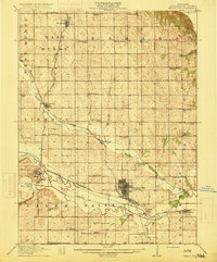
 1910 Leavenworth1910 Print · USGSLeavenworth and the Missouri River borderlands are captured here during a period of significant military and institutional growth. Researchers can trace family sites among dozens of landmarks like Slabtown, the U S Penitentiary Reserve, and Kickapoo School.8 unique versions available
 - 1910 Map of Pawhuska
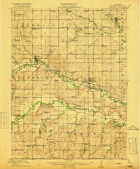
 1910 Pawhuska1910 Print · USGSOsage County's landscape at the dawn of Oklahoma statehood reveals a transition from tribal lands to a rail-connected economy. Genealogists and historians can trace early settlements like Wynona and Bigheart, or find local landmarks like Daltons Caves and White Swan Ford.2 unique versions available
 - 1913 Map of Vinita
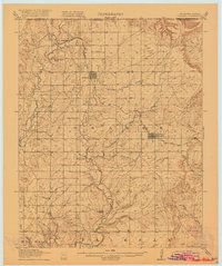
 1913 Vinita1913 Print · USGSNortheast Oklahoma at the height of its rail-and-ranch era is meticulously detailed here just as the state was entering its second decade. Genealogists can trace family roots through dozens of local landmarks like W H School, Big Cabin, and the Blue Hawk School.3 unique versions available
 - 1914 Map of Nowata
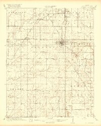
 1914 Nowata1914 Print · USGSNortheastern Oklahoma at the height of its early statehood growth is documented here as the railroad network expanded across the Verdigris River valley. Genealogists can locate dozens of country schools like Go-back School and vanished post offices such as Avelia Wayside PO.5 unique versions available
 - 1915 Map of Falls City
 1915 Falls City1915 Print · USGSRichardson County was a bustling corridor of rail lines and rural school districts during the early twentieth century. Genealogists can trace family footprints across dozens of local landmarks like Williamsville School, Straussville, and the Stone Quarry along the river.3 unique versions available
 - 1916 Map of Humboldt
 1916 Humboldt1916 Print · USGSRichardson County was a landscape of river-valley farming and emerging drainage projects during the mid-1910s. Researchers can trace the development of rural education and transport through dozens of local landmarks like Windy Lonesome School, Miles Ranch, and the Missouri Pacific line.3 unique versions available
 - 1916 Map of Foraker
 1916 Foraker1916 Print · USGSNorthern Osage County is captured here just before the First World War, showing the ranching and rail landscape of the Oklahoma-Kansas border. Family historians can locate rural landmarks like Red Eagle School, Grainola, and the Midland Valley railroad.2 unique versions available
 - 1918 Map of Columbus
 1918 Columbus1918 Print · USGSCherokee County at the end of the Great War was a crossroads of industry and agriculture, dominated by a massive network of competing railroads. Genealogists can locate dozens of country school sites like Rising Sun School and vanished rail stops at Sherwin Junction or Stippville.2 unique versions available
End of results
Showing maps 1-8 of 8
Top cities of Kansas
- Wichita historical maps
- Overland Park historical maps
- Kansas City historical maps
- Olathe historical maps
- Topeka historical maps
- Lawrence historical maps
See more
Top counties of Kansas
- Johnson County historical maps
- Sedgwick County historical maps
- Shawnee County historical maps
- Wyandotte County historical maps
- Douglas County historical maps
- Riley County historical maps
See more
Frequently asked questions
- What are the different types of historical maps available for Kansas?
- What is the oldest map of Kansas?
- Where can I purchase historical maps of Kansas for my home or office?
- Where can I download high-res historical maps of Kansas?
- Are there historical topographic maps available for Kansas?
- Is there historical aerial imagery available for Kansas?
- Where are historical maps of Kansas sourced from?