1920s Maps of Kansas
Explore 7 historic maps of Kansas from the 1920s. These maps offer a rare glimpse into what life looked like during the 1920s — showing old roads, neighborhoods, homes, and landmarks that have changed or disappeared over time.
Whether you're researching your family's past, planning a metal detecting trip, or studying how Kansas's landscape evolved across the 1920s, these high-resolution maps are a powerful tool for exploring the history of this region.
- Focus on a specific era: All maps on this page are from the 1920s, giving you a focused view of this time period.
- See what’s changed: Compare century-old streets, trails, and buildings to today's modern landscape using overlays and satellite layers.
- Research with precision: Use these maps for genealogy, historical research, land use analysis, or educational projects.
- View, download, or print: Maps are fully viewable online in high resolution, and can be downloaded or printed for your own records.
Start exploring Kansas's history through authentic maps from the 1920s. This is your window into the past.
Kansas maps
(7)- 1920 Map of Craig
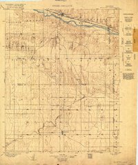
 1920 Craig1920 Print · USGSThe Missouri River bottoms and neighboring bluffs come alive in this post-war survey of the Nebraska-Missouri border. Researchers can trace dozens of rural landmarks, from the streets of Rulo and Bigelow to scattered schoolhouses like Brush College School and Idlewild School.5 unique versions available
 - 1920 Map of Syracuse
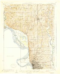
 1920 Syracuse1920 Print · USGSWestern Kansas at the close of the frontier era centers on the vital Arkansas River valley and the reach of the railroad. Genealogists and local historians can trace early prairie settlements like Gognac, Hatton, and Kendall along the Atchison Topeka and Santa Fe line.
 - 1924 Map of St. Joseph, 1960 Print
 1924 St. Joseph1960 Print · USGSNorthwest Missouri is captured in the mid-twenties as the Missouri River defines the landscape near St. Joseph. Genealogists and local historians can trace scores of rural institutions, from the State Hospital and County Farm to family-named landmarks like Old Union Cem and Gee School.2 unique versions available
 - 1926 Map of Atchison
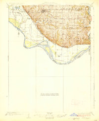
 1926 Atchison1926 Print · USGSThe Missouri River floodplain comes to life in this mid-century survey of the Kansas-Missouri borderlands. Genealogists and local historians can trace the positions of old schoolhouses like Fairview School and Enterprise School, and the busy rail activity at East Atchison Winthrop Sta.5 unique versions available
 - 1926 Map of Saint Joseph
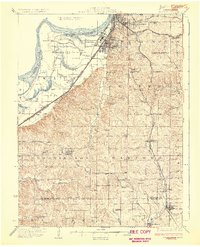
 1926 Saint Joseph1926 Print · USGSNorthwest Missouri thrived as a rail and river hub during the mid-twenties, centered on the growing industrial footprint of St. Joseph and Savannah. Researchers can trace early school districts like Liggett School, locate the historic Old Union Cem, and study the river-bottom landscape of French Bottom.3 unique versions available
 - 1926 Map of Oregon
 1926 Oregon1926 Print · USGSHolt County's river bluffs and bottomlands are captured here in the mid-1920s, showing the early infrastructure of the Missouri valley. Genealogists can trace a wealth of rural landmarks including Mayflower School, the settlement of Richville, and the Chicago Burlington and Quincy rail line.3 unique versions available
 - 1927 Map of Dearborn
 1927 Dearborn1927 Print · USGSNorthwest Missouri thrived as a rail and river hub during the mid-twenties, where the industrial Stockyards of Saint Joseph gave way to a landscape of oxbow lakes. Genealogists can trace family roots through a dense network of rural landmarks, including New Market, De Kalb, and nearly two dozen local schools like Sleepy Hollow School.3 unique versions available
End of results
Showing maps 1-7 of 7
Top cities of Kansas
- Wichita historical maps
- Overland Park historical maps
- Kansas City historical maps
- Olathe historical maps
- Topeka historical maps
- Lawrence historical maps
See more
Top counties of Kansas
- Johnson County historical maps
- Sedgwick County historical maps
- Shawnee County historical maps
- Wyandotte County historical maps
- Douglas County historical maps
- Riley County historical maps
See more
Frequently asked questions
- What are the different types of historical maps available for Kansas?
- What is the oldest map of Kansas?
- Where can I purchase historical maps of Kansas for my home or office?
- Where can I download high-res historical maps of Kansas?
- Are there historical topographic maps available for Kansas?
- Is there historical aerial imagery available for Kansas?
- Where are historical maps of Kansas sourced from?