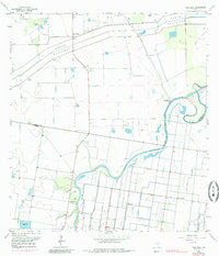
1956 Map of Paso Real
USGS Topo · Published 1985About this map
The winding course of the Arroyo Colorado and the engineered North Floodway dominate this coastal Texas landscape, illustrating the complex water management of the Rio Grande Valley. Near the river's bend, the historic site of Paso Real marks a point of long-standing local significance, complemented by the presence of Camp Perry (Boy Scouts of America) and its adjacent Rifle Range. The land use is defined by a grid of ditches and elevated structures, including a notable Aqueduct, which support the region's agricultural character.
Find a feature on this map
22 named features on this map. Tap any name to fly to it.
Don’t see what you’re looking for? This feature index may not catch every label — zoom into the map to look around manually.
Map Details
Editions of this 1956 Paso Real Map
3 editions found
Other maps of this area

1929 · Rio Hondo
USGS Topo · 1:24,000

1929 · Harlingen
USGS Topo · 1:24,000

1930 · La Leona
USGS Topo · 1:24,000

1930 · Laguna Atascosa
USGS Topo · 1:24,000

1932 · Combes
USGS Topo · 1:31,680

1932 · Rio Hondo
USGS Topo · 1:31,680

1932 · Harlingen
USGS Topo · 1:31,680

1933 · Paso Real
USGS Topo · 1:31,680

1936 · La Leona
USGS Topo · 1:31,680
1936 · Laguna Atascosa
USGS Topo · 1:31,680