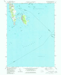
1975 Map of Sconticut Neck
USGS Topo · Published 1977This historical map portrays the area of Sconticut Neck in 1975, primarily covering Bristol County as well as portions of Plymouth County, Barnstable County, and Dukes County. Featuring a scale of 1:24000, this map provides a highly detailed snapshot of the terrain, roads, buildings, counties, and historical landmarks in the Sconticut Neck region at the time. Published in 1977, it is one of 2 known editions of this map due to revisions or reprints.
Find a feature on this map
45 named features on this map. Tap any name to fly to it.
Don’t see what you’re looking for? This feature index may not catch every label — zoom into the map to look around manually.
Map Details
Editions of this 1975 Sconticut Neck Map
2 editions found
Historical Maps of Barnstable County Through Time
44 maps found

1893 Fairhaven
Bristol County, MA

1936 New Bedford North
Bristol County, MA

1936 South Dartmouth
Bristol County, MA

1940 Sconticut Neck
Bristol County, MA

1941 New Bedford North
Bristol County, MA

1941 New Bedford South
Bristol County, MA

1943 Assonet
Bristol County, MA

1943 Somerset
Bristol County, MA

1944 Fall River East
Bristol County, MA

1944 Norton
Bristol County, MA

1948 New Bedford North
Bristol County, MA

1948 New Bedford South
Bristol County, MA

1948 Sconticut Neck
Bristol County, MA

1948 Somerset
Bristol County, MA

1951 Assonet
Bristol County, MA

1951 Fall River East
Bristol County, MA

1951 Norton
Bristol County, MA

1962 Sconticut Neck
Bristol County, MA

1963 Assonet
Bristol County, MA

1963 Fall River East
Bristol County, MA

1963 New Bedford South
Bristol County, MA

1964 New Bedford North
Bristol County, MA

1964 Norton
Bristol County, MA

1967 Somerset
Bristol County, MA

1975 Sconticut Neck
Bristol County, MA

1977 Assonet
Bristol County, MA

1977 Fall River East
Bristol County, MA

1977 New Bedford North
Bristol County, MA

1977 New Bedford South
Bristol County, MA

1977 Norton
Bristol County, MA

1977 Sconticut Neck
Bristol County, MA

1977 Somerset
Bristol County, MA

1979 New Bedford North
Bristol County, MA

1985 Somerset
Bristol County, MA

1985 Westport
Bristol County, MA

2024 Assonet
Bristol County, MA

2024 Fall River East
Bristol County, MA

2024 Head of Westport
Bristol County, MA

2024 Head of Westport OE S
Bristol County, MA

2024 New Bedford North
Bristol County, MA

2024 New Bedford South
Bristol County, MA

2024 Norton
Bristol County, MA

2024 Sconticut Neck
Bristol County, MA

2024 Somerset
Bristol County, MA