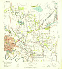
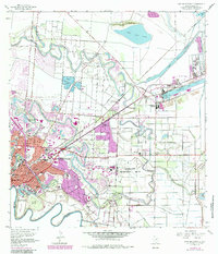
1955 Map of East Brownsville
USGS Topo · Published 1957This historical map portrays the area of East Brownsville in 1955, primarily covering Cameron County. Featuring a scale of 1:24000, this map provides a highly detailed snapshot of the terrain, roads, buildings, counties, and historical landmarks in the East Brownsville region at the time. Published in 1957, it is one of 6 known editions of this map due to revisions or reprints.
Find a feature on this map
57 named features on this map. Tap any name to fly to it.
Don’t see what you’re looking for? This feature index may not catch every label — zoom into the map to look around manually.
Map Details
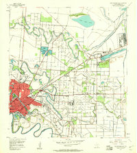
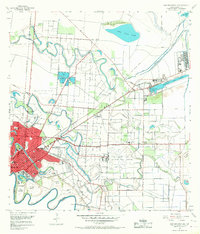
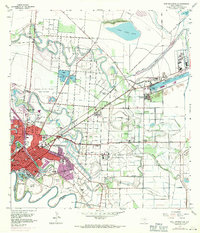
Editions of this 1955 East Brownsville Map
6 editions found
Historical Maps of Boca Chica and Medford Colonia Through Time
40 maps found

1929 Buena Vista
Cameron County, TX

1929 La Coma
Cameron County, TX

1929 Palmito Hill
Cameron County, TX

1929 Point Isabel
Cameron County, TX

1930 Barreda
Cameron County, TX

1930 East Brownsville
Cameron County, TX

1930 Laguna Atascosa
Cameron County, TX

1930 La Leona
Cameron County, TX

1930 Padre Island No. 1
Cameron County, TX

1930 Padre Island No. 2
Cameron County, TX

1930 West Brownsville
Cameron County, TX

1933 Paso Real
Cameron County, TX

1934 La Coma
Cameron County, TX

1935 Buena Vista
Cameron County, TX

1935 Padre Island No 1
Cameron County, TX

1935 Padre Island NO. 2
Cameron County, TX

1936 East Brownsville
Cameron County, TX

1936 Laguna Atascosa
Cameron County, TX

1936 La Leona
Cameron County, TX

1936 Mouth Of Rio Grande
Cameron County, TX

1936 Palmito Hill
Cameron County, TX

1936 Southmost
Cameron County, TX

1936 West Brownsville
Cameron County, TX

1954 Three Islands
Cameron County, TX

1955 East Brownsville
Cameron County, TX

1955 Fort Brown
Cameron County, TX

1955 La Coma
Cameron County, TX

1955 La Leona
Cameron County, TX

1955 La Leona
Cameron County, TX

1955 Mouth Of Rio Grande
Cameron County, TX

1955 Mouth Of Rio Grande
Cameron County, TX

1955 North Of Port Isabel
Cameron County, TX

1955 North Of Port Isabel SW
Cameron County, TX

1955 Palmito Hill
Cameron County, TX

1955 Port Isabel NW
Cameron County, TX

1955 Southmost
Cameron County, TX

1956 Laguna Atascosa
Cameron County, TX

1956 Paso Real
Cameron County, TX

1956 West Brownsville
Cameron County, TX

1956 Willamar SW
Cameron County, TX
Featured Locations
- Brownsville, TX
- Cameron Park, TX
- Cameron Park Colonia, TX
- Illinois Heights Colonia, TX
- Bautista Colonia, TX