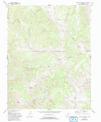
1973 Map of Palomino Mountain
USGS Topo · Published 1993About this map
The Continental Divide winds across this high-elevation landscape, forming the backbone of a wilderness region where the Rio Grande National Forest and San Juan National Forest meet. The terrain is defined by prominent peaks including Palomino Mountain, Piedra Peak, and Sugarloaf Mountain, separated by deep drainages like Porphyry Gulch and the East Fork Piedra River. This survey, updated in the early 1990s, emphasizes the protected character of the Weminuche Wilderness, where travel is restricted to an extensive system of Pack Trails.
Find a feature on this map
27 named features on this map. Tap any name to fly to it.
Don’t see what you’re looking for? This feature index may not catch every label — zoom into the map to look around manually.
Map Details
Editions of this 1973 Palomino Mountain Map
4 editions found
Other maps of this area

1905 · San Cristobal
USGS Topo · 1:125,000

1907 · San Cristobal
USGS Topo · 1:125,000

1913 · Summitville
USGS Topo · 1:125,000

1914 · Creede
USGS Topo · 1:125,000

1915 · Summitville
USGS Topo · 1:125,000

1916 · Creede
USGS Topo · 1:125,000

1924 · Pagosa Springs
USGS Topo · 1:125,000

1927 · Pagosa Springs
USGS Topo · 1:125,000

1945 · Durango
USGS Topo · 1:250,000

1953 · Durango
USGS Topo · 1:250,000