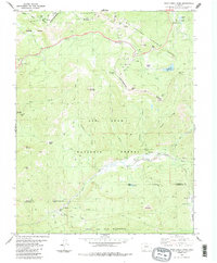
1984 Map of Wolf Creek Pass
USGS Topo · Published 1984About this map
The Continental Divide crests through this high-elevation mountain terrain in southern Colorado, marking a significant hydrological and geographical boundary between the Rio Grande National Forest and San Juan National Forest. By the mid-1980s, the area had become a established recreation and transportation corridor, centered on the famous Wolf Creek Pass. The landscape is defined by its deep alpine drainage systems, including the East Fork San Juan River and Wolf Creek, which flow through steep valleys below peaks like Treasure Mountain and Alberta Peak. Modern infrastructure is evident alongside the natural topography, notably the Wolf Creek Pass Ski Area and the Alberta Park Reservoir. Landmarks such as Lobo Overlook, the Snow Shed, and the distinctive rock formations known as The Bootjack and The Clamshell highlight the mixture of human utility and geological prominence found at this high-altitude pass.
Find a feature on this map
49 named features on this map. Tap any name to fly to it.
Don’t see what you’re looking for? This feature index may not catch every label — zoom into the map to look around manually.
Map Details
Editions of this 1984 Wolf Creek Pass Map
3 editions found
Other maps of this area

1913 · Summitville
USGS Topo · 1:125,000

1914 · Creede
USGS Topo · 1:125,000

1915 · Summitville
USGS Topo · 1:125,000

1916 · Creede
USGS Topo · 1:125,000

1945 · Durango
USGS Topo · 1:250,000

1953 · Durango
USGS Topo · 1:250,000

1954 · Durango
USGS Topo · 1:250,000

1957 · Wolf Creek Pass
USGS Topo · 1:62,500

1957 · Spar City
USGS Topo · 1:62,500

1961 · Durango
USGS Topo · 1:250,000