1920s Maps of Florida
Explore 14 historic maps of Florida from the 1920s. These maps offer a rare glimpse into what life looked like during the 1920s — showing old roads, neighborhoods, homes, and landmarks that have changed or disappeared over time.
Whether you're researching your family's past, planning a metal detecting trip, or studying how Florida's landscape evolved across the 1920s, these high-resolution maps are a powerful tool for exploring the history of this region.
- Focus on a specific era: All maps on this page are from the 1920s, giving you a focused view of this time period.
- See what’s changed: Compare century-old streets, trails, and buildings to today's modern landscape using overlays and satellite layers.
- Research with precision: Use these maps for genealogy, historical research, land use analysis, or educational projects.
- View, download, or print: Maps are fully viewable online in high resolution, and can be downloaded or printed for your own records.
Start exploring Florida's history through authentic maps from the 1920s. This is your window into the past.
Florida maps
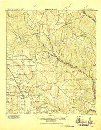
(14)- 1920 Map of Milton
 1920 Milton1920 Print · USGSSanta Rosa County's timber and rail economy is captured here just after the first World War. Genealogists and historians can trace the lumber industry through the Manu'g. and Land Co. R.R. and old coastal sites like Bagdad, Floridatown, and Roeville Sta.
 - 1920 Map of Robertsdale
 1920 Robertsdale1920 Print · USGSBaldwin County at the end of the Great War reveals a landscape defined by the timber industry and early rail expansion. Genealogists can trace the rural footprints of Silverhill and Gateswood or follow the Logging Spur lines through the Burned Woods.
 - 1921 Map of Holley
 1921 Holley1921 Print · USGSThe Florida panhandle coastline near Holley appears here as it was in the early 1920s, a landscape of quiet sounds and barrier islands. Genealogists and researchers can trace old settlements and coastal landmarks like Harper, Hiawatha, and Manatee Pt.
 - 1921 Map of Bon Secour
 1921 Bon Secour1921 Print · USGSThe Alabama coast is captured here in the early twentieth century, showing a landscape of rail-connected towns and untouched shorelines. Researchers can trace early infrastructure like the Ft. Morgan and Summerdale RR and find quiet coastal outposts like Josephine P.O. and Bon Secour.2 unique versions available
 - 1921 Map of Sand Key
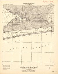
 1921 Sand Key1921 Print · USGSThe Pinellas peninsula comes alive in this early tactical survey of the gulf coast at the dawn of the Roaring Twenties. Genealogists and historians can trace early settlement patterns in Largo, Clearwater, and Anona before the post-war building boom.
 - 1921 Map of Pensacola
 1921 Pensacola1921 Print · USGSCoastal Florida in the early twentieth century reveals a landscape of maritime industry and military reserves. Map collectors and genealogists can trace the waterfront piers of Muscogee Wharf, the historic U. S. Live Oak Plantation, and early settlements like Bohemia.
 - 1921 Map of Tampa
 1921 Tampa1921 Print · USGSCoastal Florida in the early twenties shows a landscape of growing towns and deep-water ports linked by expanding railroads. Genealogists and local historians can trace the early footprints of Ybor City, locate the Turpentine Still near Limona, and follow old routes like Bull Frog Road.
 - 1921 Map of Sugar Loaf Key
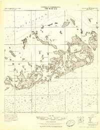 1921 Sugar Loaf Key1921 Print · USGSThe Lower Florida Keys are captured here in the early twentieth century before modern development transformed the island chain. Maritime researchers and genealogists can trace the original shorelines of Sugarloaf Key, Cudjoe Key, and family-named landmarks like Mallorys Key.2 unique versions available
 - 1921 Map of Fort Barrancas
 1921 Fort Barrancas1921 Print · USGSThe Florida-Alabama coast at the start of the 1920s reveals a landscape defined by naval history and maritime industry. Researchers can trace the military layout of Ft. Barrancas, locate Pensacola Light, and find vanished streets in Woolsey.
 - 1921 Map of Fort De Soto
 1921 Fort De Soto1921 Print · USGSThe Florida coast at the start of the twenties reveals a landscape of isolated military outposts and emerging rail towns along the Gulf. Genealogists and historians can trace early families in Bradentown, locate the U.S. Quarantine Station, and follow the Seaboard Air Line tracks.2 unique versions available
 - 1921 Map of Key West
 1921 Key West1921 Print · USGSKey West at the end of the Florida East Coast Railway era is meticulously detailed in this early twentieth-century tactical survey. You can trace the island's coastal defenses at the E. Martello Tower and locate maritime landmarks like the N.W. Bar Light.
 - 1921 Map of St Petersburg
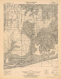
 1921 St Petersburg1921 Print · USGSThe Pinellas Peninsula just after the First World War shows a world of mangrove swamps, tidal bayous, and emerging settlements. Genealogists and local historians can trace early neighborhood footprints and coastal landmarks from Pinellas Park and Lealman to the growing streets of St. Petersburg.2 unique versions available
 - 1921 Map of Muscogee
 1921 Muscogee1921 Print · USGSThe Alabama-Florida borderlands come to life in the early 1920s, showing the river-and-rail network that sustained the region. Trace old ferry crossings like Billy Malone Ferry and landmarks such as Lathams Chapel and Seminola P.O.
 - 1927 Map of Matanzas
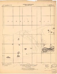
 1927 Matanzas1927 Print · USGSThe Florida coast near the border of St. Johns and Flagler Counties comes to life in this mid-1930s survey. Researchers can trace the early path of State Hy No 140 and locate vanished coastal sites like Summer Haven, Shell, and Hopper.
End of results
Showing maps 1-14 of 14
Top cities of Florida
- Jacksonville historical maps
- Miami historical maps
- Tampa historical maps
- Orlando historical maps
- Saint Petersburg historical maps
- Hialeah historical maps
See more
Top counties of Florida
- Miami-Dade County historical maps
- Broward County historical maps
- Palm Beach County historical maps
- Hillsborough County historical maps
- Orange County historical maps
- Pinellas County historical maps
See more
Frequently asked questions
- What are the different types of historical maps available for Florida?
- What is the oldest map of Florida?
- Where can I purchase historical maps of Florida for my home or office?
- Where can I download high-res historical maps of Florida?
- Are there historical topographic maps available for Florida?
- Is there historical aerial imagery available for Florida?
- Where are historical maps of Florida sourced from?