1951 Map of Bertrandville
USGS Topo · Published 1952About this map
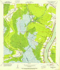
Barataria Bayou and the Intracoastal Waterway define the water-bound geography of this delta landscape, where the land transitions from the established riverbank settlements of the Mississippi River into the vast marshlands of the interior. Along the river's western bank, a string of historic communities including Bertrandville, Oakville, and Augusta follow the fertile levee lands, while further inland, Crown Point and Bayou des Familles mark the limit of habitable terrain.
Find a feature on this map
40 named features on this map. Tap any name to fly to it.
Don’t see what you’re looking for? This feature index may not catch every label — zoom into the map to look around manually.
Map Details
Editions of this 1951 Bertrandville Map
2 editions found
Historical Maps of Gretna Through Time
61 maps found

1891 Spanish Fort
Jefferson Parish, LA

1932 New Orleans NW
Jefferson Parish, LA

1932 New Orleans SE
Jefferson Parish, LA

1932 Sabine Pass NE
Jefferson Parish, LA

1936 Spanish Fort
Jefferson Parish, LA

1938 Indian Beach
Jefferson Parish, LA

1938 New Orleans West
Jefferson Parish, LA

1939 Lorman
Jefferson Parish, LA

1940 Bertrandville
Jefferson Parish, LA

1946 Sabine Pass NE
Jefferson Parish, LA

1947 Bertrandville
Jefferson Parish, LA

1949 Barataria Pass
Jefferson Parish, LA

1951 Bertrandville
Jefferson Parish, LA

1951 New Orleans West
Jefferson Parish, LA

1952 Indian Beach
Jefferson Parish, LA

1953 Spanish Fort
Jefferson Parish, LA

1965 Indian Beach
Jefferson Parish, LA

1965 New Orleans West
Jefferson Parish, LA

1966 Bertrandville
Jefferson Parish, LA

1967 Spanish Fort
Jefferson Parish, LA

1973 Barataria Pass
Jefferson Parish, LA

1973 Three Bayou Bay
Jefferson Parish, LA

1992 Bertrandville
Jefferson Parish, LA

1992 Indian Beach
Jefferson Parish, LA

1992 New Orleans West
Jefferson Parish, LA

1993 Barataria Pass
Jefferson Parish, LA

1995 Bertrandville
Jefferson Parish, LA

1998 Indian Beach
Jefferson Parish, LA

1998 New Orleans West
Jefferson Parish, LA

1998 Three Bayou Bay
Jefferson Parish, LA

2012 Barataria Pass
Jefferson Parish, LA

2012 Bertrandville
Jefferson Parish, LA

2012 Indian Beach
Jefferson Parish, LA

2012 New Orleans West
Jefferson Parish, LA

2012 Spanish Fort NE OE W
Jefferson Parish, LA

2012 Three Bayou Bay
Jefferson Parish, LA

2015 Barataria Pass
Jefferson Parish, LA

2015 Bertrandville
Jefferson Parish, LA

2015 Indian Beach
Jefferson Parish, LA

2015 New Orleans West
Jefferson Parish, LA

2015 Spanish Fort NE OE W
Jefferson Parish, LA

2015 Three Bayou Bay
Jefferson Parish, LA

2018 Barataria Pass
Jefferson Parish, LA

2018 Bertrandville
Jefferson Parish, LA

2018 Indian Beach
Jefferson Parish, LA

2018 New Orleans West
Jefferson Parish, LA

2018 Spanish Fort NE OE W
Jefferson Parish, LA

2018 Three Bayou Bay
Jefferson Parish, LA

2020 Barataria Pass
Jefferson Parish, LA

2020 Bertrandville
Jefferson Parish, LA

2020 Indian Beach
Jefferson Parish, LA

2020 New Orleans West
Jefferson Parish, LA

2020 Spanish Fort NE OE W
Jefferson Parish, LA

2020 Three Bayou Bay
Jefferson Parish, LA

2024 Barataria Pass
Jefferson Parish, LA

2024 Bertrandville
Jefferson Parish, LA

2024 Indian Beach
Jefferson Parish, LA

2024 New Orleans West
Jefferson Parish, LA

2024 Spanish Fort NE OE W
Jefferson Parish, LA

2024 Three Bayou Bay
Jefferson Parish, LA

2025 Barataria Pass
Jefferson Parish, LA