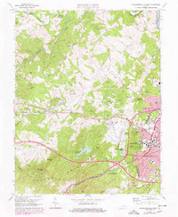
1973 Map of Charlottesville West
USGS Topo · Published 1978About this map
The University of Virginia campus anchors the eastern edge of this mid-1970s survey, revealing the institutional expansion and suburban development of the western Charlottesville area. Detailed purple revisions illustrate the rapid growth of residential clusters like Hessian Hills and Ednam Forest, alongside established landmarks such as the McCormick Observatory on Mt Jefferson. The landscape transitions from the dense urban grid near Scott Stadium and University Hall into the foothills of the Ragged Mountains, where family-named summits like Turners Mtn and Gillums Mtn overlook the winding courses of the Mechums River and Moormans River. Local life is recorded through small country institutions, including Oak Union Ch and the Meriwether Lewis Sch, while the infrastructure of the era is marked by the crossing lines of the Southern and Chesapeake and Ohio railroads.
Find a feature on this map
68 named features on this map. Tap any name to fly to it.
Don’t see what you’re looking for? This feature index may not catch every label — zoom into the map to look around manually.
Map Details
Editions of this 1973 Charlottesville West Map
3 editions found
Other maps of this area

1891 · Palmyra
USGS Topo · 1:125,000

1892 · Buckingham
USGS Topo · 1:125,000

1892 · Gordonsville
USGS Topo · 1:125,000

1892 · Harrisonburg
USGS Topo · 1:125,000

1895 · Palmyra
USGS Topo · 1:125,000

1897 · Palmyra
USGS Topo · 1:125,000

1929 · Covesville
USGS Topo · 1:62,500

1931 · University
USGS Topo · 1:62,500

1935 · Charlottesville
USGS Topo · 1:62,500

1935 · Charlottesville And Vicinity
USGS Topo · 1:31,680