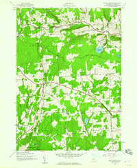
1943 Map of East Pharsalia
USGS Topo · Published 1960This historical map portrays the area of East Pharsalia in 1943, primarily covering Chenango County. Featuring a scale of 1:24000, this map provides a highly detailed snapshot of the terrain, roads, buildings, counties, and historical landmarks in the East Pharsalia region at the time. Published in 1960, it is one of 3 known editions of this map due to revisions or reprints.
Find a feature on this map
27 named features on this map. Tap any name to fly to it.
Don’t see what you’re looking for? This feature index may not catch every label — zoom into the map to look around manually.
Map Details
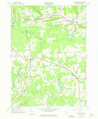
Editions of this 1943 East Pharsalia Map
3 editions found
Historical Maps of East Pharsalia Through Time
35 maps found

1902 Oxford
Chenango County, NY

1904 Greene
Chenango County, NY

1904 Oxford
Chenango County, NY

1910 New Berlin
Chenango County, NY

1912 New Berlin
Chenango County, NY

1915 Unadilla
Chenango County, NY

1918 Unadilla
Chenango County, NY

1943 East Pharsalia
Chenango County, NY

1943 Guilford
Chenango County, NY

1943 Holmesville
Chenango County, NY

1943 New Berlin North
Chenango County, NY

1943 Otselic
Chenango County, NY

1943 Pitcher
Chenango County, NY

1943 Sherburne
Chenango County, NY

1943 Sidney
Chenango County, NY

1943 South Otselic
Chenango County, NY

1944 East Pharsalia
Chenango County, NY

1944 Otselic
Chenango County, NY

1944 Pitcher
Chenango County, NY

1944 South Ostelic
Chenango County, NY

1945 Guilford
Chenango County, NY

1945 Holmesville
Chenango County, NY

1945 New Berlin North
Chenango County, NY

1945 Sherburne
Chenango County, NY

1945 Sidney
Chenango County, NY

1948 Greene
Chenango County, NY

1949 Brisben
Chenango County, NY

1949 Oxford
Chenango County, NY

1949 Tyner
Chenango County, NY

1949 West Bainbridge
Chenango County, NY

1950 Greene
Chenango County, NY

1951 Brisben
Chenango County, NY

1951 Oxford
Chenango County, NY

1951 Tyner
Chenango County, NY

1951 West Bainbridge
Chenango County, NY