1958 Map of Blue Hills
USGS Topo · Published 1960About this map
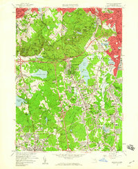
Great Blue Hill and a series of prominent peaks including Chickatawbut Hill and Nahanton Hill dominate this landscape south of Boston during the late 1950s. The map reveals a region transitioning from its industrial roots, evidenced by the numerous Quarries in West Quincy, toward a suburban and institutional character. Educational and religious landmarks are densely clustered here, from Milton Academy and Curry College in the north to the Boston School for the Deaf and St Marys Sch in Randolph.
Find a feature on this map
126 named features on this map. Tap any name to fly to it.
Don’t see what you’re looking for? This feature index may not catch every label — zoom into the map to look around manually.
Map Details
Editions of this 1958 Blue Hills Map
2 editions found
Historical Maps of Boston Through Time
61 maps found

1886 Dedham
Norfolk County, MA

1887 Franklin
Norfolk County, MA

1889 Franklin
Norfolk County, MA

1893 Franklin
Norfolk County, MA

1894 Dedham
Norfolk County, MA

1919 Dedham
Norfolk County, MA

1919 Franklin
Norfolk County, MA

1921 Franklin
Norfolk County, MA

1936 Blue Hills
Norfolk County, MA

1936 Mansfield
Norfolk County, MA

1936 Norwood
Norfolk County, MA

1936 Weymouth
Norfolk County, MA

1939 Franklin
Norfolk County, MA

1940 Franklin
Norfolk County, MA

1940 Medfield
Norfolk County, MA

1940 Wrentham
Norfolk County, MA

1941 Blue Hills
Norfolk County, MA

1941 Mansfield
Norfolk County, MA

1941 Norwood
Norfolk County, MA

1941 Weymouth
Norfolk County, MA

1945 Franklin
Norfolk County, MA

1945 Medfield
Norfolk County, MA

1945 Wrentham
Norfolk County, MA

1946 Blue Hills
Norfolk County, MA

1946 Franklin
Norfolk County, MA

1946 Mansfield
Norfolk County, MA

1946 Medfield
Norfolk County, MA

1946 Norwood
Norfolk County, MA

1946 Wrentham
Norfolk County, MA

1947 Norwood
Norfolk County, MA

1947 Weymouth
Norfolk County, MA

1954 Blue Hills
Norfolk County, MA

1957 Medfield
Norfolk County, MA

1958 Blue Hills
Norfolk County, MA

1958 Norwood
Norfolk County, MA

1958 Weymouth
Norfolk County, MA

1964 Franklin
Norfolk County, MA

1964 Mansfield
Norfolk County, MA

1964 Wrentham
Norfolk County, MA

1965 Franklin
Norfolk County, MA

1970 Medfield
Norfolk County, MA

1970 Norwood
Norfolk County, MA

1971 Blue Hills
Norfolk County, MA

1971 Weymouth
Norfolk County, MA

1977 Blue Hills
Norfolk County, MA

1977 Franklin
Norfolk County, MA

1977 Mansfield
Norfolk County, MA

1977 Medfield
Norfolk County, MA

1977 Norwood
Norfolk County, MA

1977 Weymouth
Norfolk County, MA

1977 Wrentham
Norfolk County, MA

1985 Norwood
Norfolk County, MA

1987 Franklin
Norfolk County, MA

1987 Medfield
Norfolk County, MA

2024 Blue Hills
Norfolk County, MA

2024 Franklin
Norfolk County, MA

2024 Mansfield
Norfolk County, MA

2024 Medfield
Norfolk County, MA

2024 Norwood
Norfolk County, MA

2024 Weymouth
Norfolk County, MA

2024 Wrentham
Norfolk County, MA