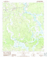
1988 Map of Green Pond
USGS Topo · Published 1988About this map
Green Pond and the surrounding Lowcountry wetlands are defined by an intricate network of tidal waterways and levees in this late 20th-century survey. The confluence of the Ashepoo River and the Chehaw dominates the southern landscape, where Minkey Island sits amidst a maze of marshy channels. The map reveals the critical role of water management in this coastal environment, with numerous levees lining the banks of Social Hall Creek and Deer Creek. Settlement is concentrated near the historic Ashepoo station and the Ashepoo Siding along the rail corridor, while small Cem locations scattered through the interior offer valuable clues for genealogists researching family landholdings in Colleton County. The terrain is characterized by low-lying elevations, transitioning from the higher ground near Horseshoe Cr into the expansive saltwater marshes that have shaped the region's economy and settlement patterns for centuries.
Find a feature on this map
12 named features on this map. Tap any name to fly to it.
Don’t see what you’re looking for? This feature index may not catch every label — zoom into the map to look around manually.
Map Details
Editions of this 1988 Green Pond Map
This is the sole edition of this map. No revisions or reprints were ever made.
Other maps of this area

1918 · Walterboro
USGS Topo · 1:62,500

1918 · Green Pond
USGS Topo · 1:62,500

1918 · Cottageville
USGS Topo · 1:62,500

1919 · Edisto Island
USGS Topo · 1:62,500

1943 · Cottageville
USGS Topo · 1:62,500

1943 · Edisto Island
USGS Topo · 1:62,500

1943 · Green Pond
USGS Topo · 1:62,500

1943 · Walterboro
USGS Topo · 1:62,500

1947 · Savannah
USGS Topo · 1:250,000

1948 · Savannah
USGS Topo · 1:250,000