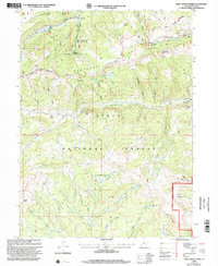
1998 Map of Wolf Creek Summit
USGS Topo · Published 2002About this map
The Heber Ranger District serves as the focal point for this late-1990s documentation of the high-country transition between Duchesne County and the Uinta National Forest. The landscape is defined by the headwaters of the Duchesne River and its numerous tributaries, including Wolf Creek and Vat Creek. Specialized facilities like the Mill Hollow Guard Station and the Mill Hollow Granite School Center indicate the area's importance for both administrative forest management and outdoor education during this era. Recreation and water resource management are evidenced by the Mill Hollow Reservoir and several designated sites such as the Wolf Creek Campground. To the north and west, the map details the boundary of the Uinta and Ouray Indian Reservation, highlighting the intersection of tribal lands and national forest territory amidst a network of pack trails and forest roads like the Wolf Creek Trail.
Find a feature on this map
50 named features on this map. Tap any name to fly to it.
Don’t see what you’re looking for? This feature index may not catch every label — zoom into the map to look around manually.
Map Details
Editions of this 1998 Wolf Creek Summit Map
This is the sole edition of this map. No revisions or reprints were ever made.
Other maps of this area

1885 · Salt Lake
USGS Topo · 1:250,000

1885 · Uinta
USGS Topo · 1:250,000

1900 · Coalville
USGS Topo · 1:125,000

1901 · Hayden Peak
USGS Topo · 1:125,000

1903 · Hayden Peak
USGS Topo · 1:125,000

1903 · Coalville
USGS Topo · 1:125,000

1907 · Strawberry Valley
USGS Topo · 1:125,000

1909 · Strawberry Valley
USGS Topo · 1:125,000

1954 · Salt Lake City
USGS Topo · 1:250,000

1958 · Salt Lake City
USGS Topo · 1:250,000