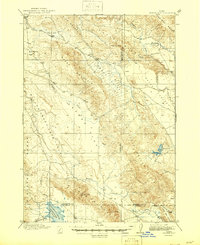
1917 Map of Cranes Flat
USGS Topo · Published 1946About this map
Cranes Flat and the high ridges of the Caribou Range dominate this Idaho landscape as surveyed in the early twentieth century. The map centers on a high-altitude ranching and drainage system where Homer Creek and Cranes Creek feed into broader basins like Outlet Valley. Evidence of early pioneer land use is found at the isolated Hancock Ranch, while the southern reaches show the early footprint of the Blackfoot River Reservoir along the Blackfoot River. The topography is defined by dramatic peaks including Sheep Mountain, Limerock Mtn, and Sugarloaf Mtn. This survey captures the region's hydrography before modern water management significantly altered the high desert basins, showing the natural course of Willow Creek and the seasonal Meadow Creek as they navigate the complex divides between Bonneville, Bingham, and Caribou counties.
Find a feature on this map
23 named features on this map. Tap any name to fly to it.
Don’t see what you’re looking for? This feature index may not catch every label — zoom into the map to look around manually.
Map Details
Editions of this 1917 Cranes Flat Map
3 editions found
Other maps of this area

1914 · Henry
USGS Topo · 1:48,000

1915 · Lanes Creek
USGS Topo · 1:62,500

1916 · Henry
USGS Topo · 1:62,500

1917 · Portneuf
USGS Topo · 1:62,500

1917 · Cranes Flat
USGS Topo · 1:62,500

1918 · Paradise Valley
USGS Topo · 1:62,500

1924 · Hell Creek
USGS Topo · 1:62,500

1924 · Ammon
USGS Topo · 1:62,500

1926 · Hell Creek
USGS Topo · 1:62,500

1932 · Irwin
USGS Topo · 1:96,000