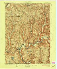
1926 Map of Deposit
USGS Topo · Published 1926This historical map portrays the area of Deposit in 1926, primarily covering Delaware County as well as portions of Chenango County and Broome County. Featuring a scale of 1:62500, this map provides a highly detailed snapshot of the terrain, roads, buildings, counties, and historical landmarks in the Deposit region at the time. Published in 1926, it is one of 4 known editions of this map due to revisions or reprints.
Find a feature on this map
88 named features on this map. Tap any name to fly to it.
Don’t see what you’re looking for? This feature index may not catch every label — zoom into the map to look around manually.
Map Details
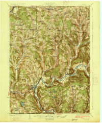
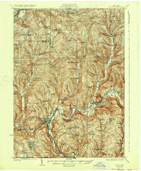
Editions of this 1926 Deposit Map
4 editions found
Historical Maps of Broome County Through Time
45 maps found

1909 Delhi
Delaware County, NY

1911 Delhi
Delaware County, NY

1920 Long Eddy
Delaware County, NY

1921 Long Eddy
Delaware County, NY

1922 Andes
Delaware County, NY

1923 Long Eddy
Delaware County, NY

1923 Walton
Delaware County, NY

1924 Andes
Delaware County, NY

1924 Deposit
Delaware County, NY

1925 Walton
Delaware County, NY

1926 Deposit
Delaware County, NY

1943 Davenport
Delaware County, NY

1943 Delhi
Delaware County, NY

1943 Treadwell
Delaware County, NY

1943 Unadilla
Delaware County, NY

1943 West Davenport
Delaware County, NY

1944 Deposit
Delaware County, NY

1944 Long Eddy
Delaware County, NY

1945 Davenport
Delaware County, NY

1945 Harpersfield
Delaware County, NY

1945 Roxbury
Delaware County, NY

1945 Treadwell
Delaware County, NY

1945 Unadilla
Delaware County, NY

1945 West Davenport
Delaware County, NY

1946 Harpersfield
Delaware County, NY

1946 Roxbury
Delaware County, NY

1965 Andes
Delaware County, NY

1965 Cannonsville Reservoir
Delaware County, NY

1965 Corbett
Delaware County, NY

1965 Fishs Eddy
Delaware County, NY

1965 Hamden
Delaware County, NY

1965 Horton
Delaware County, NY

1965 Lewbeach
Delaware County, NY

1965 Long Eddy
Delaware County, NY

1965 North Sanford
Delaware County, NY

1965 Readburn
Delaware County, NY

1965 Trout Creek
Delaware County, NY

1965 Walton East
Delaware County, NY

1965 Walton West
Delaware County, NY

1982 Hamden
Delaware County, NY

1982 Harpersfield
Delaware County, NY

1982 Horton
Delaware County, NY

1986 Pepacton Reservoir
Delaware County, NY

1992 Hancock
Delaware County, NY

1992 Long Eddy
Delaware County, NY