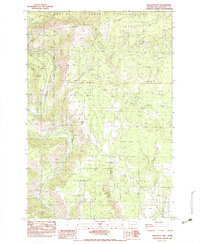
1983 Map of Grayback Mtn
USGS Topo · Published 1983About this map
The Klickitat State Wildlife Recreation Area dominates this early 1980s landscape, where the Klickitat River carves through deep canyons beneath the Simcoe Mountains. Evidence of timber and utility infrastructure is widespread, from the Wood Pole Telephone Line to the remnants of an Old Railway Grade tracing the higher elevations near Summit Creek. The map documents a period of managed forest and recreation, with established sites like Koldera Camp, Kraft Camp, and Leidl Campground providing access to the rugged terrain. To the north, the boundary of the Yakima Indian Reservation marks a transition in land management, while to the east, the topography levels into the broad opening of Crofton Prairie. Significant landmarks include the prominent summit of Grayback Mtn and the unique geological features of Simpson Flats and Quincy Flats.
Find a feature on this map
21 named features on this map. Tap any name to fly to it.
Don’t see what you’re looking for? This feature index may not catch every label — zoom into the map to look around manually.
Map Details
Editions of this 1983 Grayback Mtn Map
This is the sole edition of this map. No revisions or reprints were ever made.
Other maps of this area

1904 · Mount Adams
USGS Topo · 1:125,000

1907 · Mount Adams
USGS Topo · 1:125,000

1934 · The Dalles
USGS Topo · 1:125,000

1937 · White Swan
USGS Topo · 1:125,000

1950 · Yakima
USGS Topo · 1:250,000

1953 · The Dalles
USGS Topo · 1:250,000

1956 · The Dalles
USGS Topo · 1:250,000

1957 · The Dalles
USGS Topo · 1:250,000

1957 · Klickitat
USGS Topo · 1:62,500

1957 · Goldendale
USGS Topo · 1:62,500