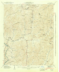
1942 Map of Hepco
USGS Topo · Published 1942About this map
Pisgah National Forest encompasses the high ridgelines of this 1941 field examination, where the Newfound Mountains and Hurricane Mountain divide the drainage basins of Fines Creek and the Meadow Fork of Spring Creek. The settlement of Hepco sits at a bend in the river near a Gaging Station, serving as a focal point for the surrounding mountain hollows. The social fabric of these remote gaps is clearly marked by a high density of rural institutions, including Fines Creek Ch, Fines Creek Sch, and Bellmont Ch. The map details a network of family-named landmarks and high-altitude crossings like Betsey Gap and Bear Wallow Gap, providing a window into the topographic constraints on Appalachian travel before modern highway expansion. Significant elevations like Sandymush Bald and Ravencliff Mtn anchor the tri-county corner where Haywood, Madison, and Buncombe counties meet.
Find a feature on this map
133 named features on this map. Tap any name to fly to it.
Don’t see what you’re looking for? This feature index may not catch every label — zoom into the map to look around manually.
Map Details
Editions of this 1942 Hepco Map
2 editions found
Other maps of this area

1893 · Mt Guyot
USGS Topo · 1:125,000

1894 · Asheville
USGS Topo · 1:125,000

1901 · Asheville
USGS Topo · 1:125,000

1912 · Mt Guyot
USGS Topo · 1:125,000

1935 · Newport
USGS Topo · 1:48,000

1935 · Canton
USGS Topo · 1:24,000

1935 · Dellwood
USGS Topo · 1:24,000

1935 · Clyde
USGS Topo · 1:24,000

1935 · Spring Creek
USGS Topo · 1:24,000

1935 · Lemon Gap
USGS Topo · 1:24,000